Pocahontas is a town in Tazewell County, Virginia, United States. It was named for Chief Powhatan's daughter, Pocahontas, who lived in the 17th-century Jamestown Settlement. The town was founded as a company mining town by the Southwest Virginia Improvement Company in 1881. It was the first company mining town in Virginia. The post office opened on June 30, 1882.

Williamson is a city in Mingo County, West Virginia, United States, situated along the Tug Fork River. The population was 3,042 at the 2020 census. It is the county seat of Mingo County, and is the county's largest and most populous city. Williamson is home to Southern West Virginia Community and Technical College. The Tug Fork River separates Williamson from South Williamson, Kentucky.

Multnomah Falls is a waterfall located on Multnomah Creek in the Columbia River Gorge, east of Troutdale, between Corbett and Dodson, Oregon, United States. The waterfall is accessible from the Historic Columbia River Highway and Interstate 84. Spanning two tiers on basalt cliffs, it is the tallest waterfall in the state of Oregon at 620 ft (189 m) in height. The Multnomah Creek Bridge, built in 1914, crosses below the falls, and is listed on the National Register of Historic Places.

The American Discovery Trail is a system of recreational trails and roads that collectively form a coast-to-coast hiking and biking trail across the mid-tier of the United States. Horses can also be ridden on most of this trail. The coastal trailheads are the Delmarva Peninsula on the Atlantic Ocean and the northern California coast on the Pacific Ocean. The trail has northern and southern alternates for part of its distance, passing through Chicago and St. Louis respectively. The total length of the trail, including both the north and south routes, is 6,800 miles (10,900 km). The northern route covers 4,834 miles (7,780 km) with the southern route covering 5,057 miles (8,138 km). It is the only non-motorized coast-to-coast trail.

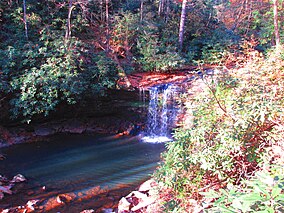
Cloudland Canyon State Park is a 3,485 acres (14.10 km2) Georgia state park located near Trenton and Cooper Heights on the western edge of Lookout Mountain. One of the largest and most scenic parks in Georgia, it contains rugged geology, and offers visitors a range of vistas across the deep gorge cut through the mountain by Sitton Gulch Creek, where the elevation varies from 800 to over 1,800 feet. Views of the canyon can be seen from the picnic area parking lot, in addition to additional views located along the rim trail. At the bottom of the gorge, two waterfalls cascade across layers of sandstone and shale, ending in small pools below.

Beartown State Park is a 110-acre (45 ha) state park located on the eastern summit of Droop Mountain, 7 miles (11 km) southwest of Hillsboro, West Virginia, in northern Greenbrier County, West Virginia. The land was purchased in 1970 with funds from the Nature Conservancy and a donation from Mrs. Edwin G. Polan, in memory of her son, Ronald Keith Neal, a local soldier who was killed in the Vietnam War. Development of the park has been minimal in order to preserve the natural attractions of the area. Recreation in the park consists of hiking along improved trails and boardwalks. Markers explain the natural processes at work in the area. The name "Beartown State Park" was chosen because local residents claimed that many cave-like openings in the rocks made ideal winter dens for the native black bears, the state animal of West Virginia. Also because the many deep, narrow crevasses were formed in a regular criss-cross pattern which appear from above like the streets of a small town. Beartown is noted for its unusual rock formations, which consist of Droop, or Pottsville, Sandstone formed during the Pennsylvanian age. Massive boulders, overhanging cliffs and deep crevasses make up the beauty of the park. On the face of the cliffs are hundreds of eroded pits. These pits range from the size of a marble to others large enough to hold two grown men. It is not unusual to see ice and snow remaining in the deeper crevasses until midsummer.

Hawks Nest State Park is located on 370 acres (150 ha) in Fayette County near Ansted, West Virginia. The park's clifftop overlook along U.S. Route 60 provides a scenic vista of the New River, some 750 feet below. The hydro-electric project tunnel that passes underneath nearby Gauley Mountain was the scene of the Depression-era Hawks Nest Tunnel disaster.

Opened in 1933, the 6,115-acre (2,475 ha) Cacapon Resort State Park is located on the eastern slopes of Cacapon Mountain in Morgan County, West Virginia, USA. Panorama Overlook, at the southern end of the park and 2,320 feet (710 m) above sea level, is the highest point in the park and in Morgan County.
Taconic State Park is located in Columbia and Dutchess County, New York abutting Massachusetts and Connecticut within the Taconic Mountains. The state park is located off New York State Route 344 south of Interstate 90 and 110 miles (180 km) north of New York City. It features camping, hiking, bicycling, hunting, cross county skiing and other recreational opportunities.

The Greenbrier River Trail (GRT), is a lineal state park comprising a 77.1-mile (124.1 km) rail trail between North Caldwell and Cass in eastern West Virginia, United States.
Holly River State Park is a state park located in Webster County, West Virginia. Situated on the Left Fork of the Holly River near the town of Hacker Valley, it is the second largest park in the West Virginia state park system with a total of 8,294 acres (3,356 ha). The park features over 42 miles (68 km) of hiking trails, ten vacation cabins, an 88-unit campground, and many recreation and picnic areas.

Babcock State Park is a state park located along the New River Gorge on 4,127 acres (16.7 km2) wooded in Fayette County, West Virginia. It is located approximately 20 miles away from the New River Gorge Bridge.
The Hatfield–McCoy Trails (HMT) is a trail system popular for its recreational trails for ATVs, UTVs, and dirt bikes, but the trails are also open to hikers, mountain bikers, and horse riders. HMT is located in West Virginia's south west counties of Boone, Kanawha, Lincoln, Logan, McDowell, Mercer, Mingo, Wayne, and Wyoming. The HMT trail system is a public–private partnership between private landowners and the Hatfield–McCoy Regional Recreation Authority (HMRRA), a legislatively created quasi-state agency with paid staff and governed by a multi-county board of directors. The HMT project brings in millions of dollars to the West Virginia economy each year.

Blackwater Falls State Park is located in the Allegheny Mountains of Tucker County, West Virginia, US. The centerpiece of the park is Blackwater Falls, a 62-foot (19 m) cascade where the Blackwater River leaves its leisurely course in Canaan Valley and enters rugged Blackwater Canyon. It is among the most photographed venues in the state and appears on calendars, stationery, and advertisements. The river is named for its tannin-darkened water.

Chief Logan State Park is located on 3,988 acres (1,614 ha) about 4 miles (6.4 km) north of Logan in Logan County, West Virginia, United States. The park, the town and the county were all named after Chief Logan, a Mingo Native American leader who lived in the region before the American Revolutionary War. Each summer the Liz Spurlock Amphitheater at Chief Logan State Park is the site for outdoor dramas, including the historical drama "The Aracoma Story" about Shawnee tribal members who lived at the present-day location of the town of Logan. The outdoor drama theater produces the Aracoma story and two to three other plays or musicals every year.

North Bend State Park sits on 2,459 acres (995 ha) along the North Fork of the Hughes River in Ritchie County near Harrisville, West Virginia. The park is named after the sharp bend in the river that the formed three sides of the original park boundary. The North Bend Rail Trail, a 72-mile (116 km) hiking and biking corridor, is also managed as a unit of the park. A new 305 acre (1.23 km2) lake was recently added to the park.

The Palouse to Cascades State Park Trail, formerly known as the John Wayne Pioneer Trail and the Iron Horse Trail, is a rail trail that spans most of the U.S. state of Washington. It follows the former railway roadbed of the Chicago, Milwaukee, St. Paul & Pacific Railroad for 300 miles (480 km) across two-thirds of the state, from the western slopes of the Cascade Mountains to the Idaho border.
Erie MetroParks was formed as the "Erie County Metropolitan Park District" in 1968 and adopted its current name in 1991. It consists of 14 individual park areas located throughout Erie County in the US state of Ohio covering approximately 3,200 acres (1,300 ha).

The Nehantic Trail is a 13-mile (21 km) Connecticut hiking trail and is one of the Blue-Blazed hiking trails maintained by the Connecticut Forest and Park Association.

Winchell Trail is a five-mile (8 km) round trip, pedestrian-only trail in Minneapolis, Minnesota, United States, that runs along the west side of the Mississippi River between Franklin Avenue South and East 44th Street. Popular with birdwatchers and naturalists, the rustic trail provides Upper Mississippi River gorge access and views. The trail is separate from the adjacent multi-use bicycle path, taking hikers past sandy beaches, an oak savanna restoration project, and the floodplain forest. The trail has multiple access points and the section from East 38th Street to East 44th Street is paved. Described as moderate and for all hiking skill levels, the out-and-back Winchell Trail has total elevation gain of 501 feet (153 m). Parts of it can be hiked in near solitude as its age and general dilapidation have made it widely forgotten.