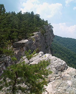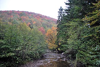
The Monongahela National Forest is a national forest located in the Allegheny Mountains of eastern West Virginia, USA. It protects over 921,000 acres of federally managed land within a 1,700,000 acres proclamation boundary that includes much of the Potomac Highlands Region and portions of 10 counties.

The Dolly Sods Wilderness is a U.S. Wilderness Area in the Allegheny Mountains of eastern West Virginia and is part of the Monongahela National Forest of the U.S. Forest Service.

The George Washington and Jefferson National Forests is an administrative entity combining two U.S. National Forests into one of the largest areas of public land in the Eastern United States. The forests cover 1.8 million acres (2,800 sq mi) of land in the Appalachian Mountains of Virginia, West Virginia, and Kentucky. Approximately 1 million acres (1,600 sq mi) of the forest are remote and undeveloped and 139,461 acres (218 sq mi) have been designated as wilderness areas, which prohibits future development.

The Dry Fork is a 39.1-mile-long (62.9 km) tributary of the Black Fork of the Cheat River in the Allegheny Mountains of eastern West Virginia, USA. Via the Black Fork, the Cheat, and the Monongahela and Ohio rivers, it is part of the watershed of the Mississippi River. The Dry Fork flows for much of its length in the Monongahela National Forest and drains mostly rural and forested areas. It was traditionally considered one of the five Forks of Cheat.

The Williams River is a tributary of the Gauley River, 33 miles (53 km) long, in east-central West Virginia, USA. Via the Gauley, Kanawha and Ohio Rivers, it is part of the watershed of the Mississippi River, draining an area of 132 square miles (342 km2) in a sparsely populated region of the southern Allegheny Mountains and the unglaciated portion of the Allegheny Plateau.
The Potomac Highlands of West Virginia centers on five West Virginian counties in the upper Potomac River watershed in the western portion of the state's Eastern Panhandle, bordering Maryland and Virginia. Because of geographical proximity, similar topography and landscapes, and shared culture and history, the Potomac Highlands region also includes Pocahontas, Randolph, and Tucker counties, even though they are in the Monongahela River or New River watersheds and not that of the Potomac River.

Shavers Fork Mountain Complex is the name given to the mountains on either side of Shavers Fork in the highlands portions of Randolph County, Pocahontas County, and Tucker County in West Virginia, USA. Much of the land surrounding the river and its adjacent mountains is protected by Monongahela National Forest including about 20,000 acres (81 km2) of designated wilderness.

North Fork Mountain is a quartzite-capped mountain ridge in the Ridge and Valley physiographic province of the Allegheny Mountains, also known as the High Alleghenies or Potomac Highlands, of eastern West Virginia. Kile Knob, at 4,588 feet, is the mountain's highest point, and Panther Knob and Pike Knob are nearly as high.

Laurel Fork is a 37.8-mile-long (60.8 km) river in eastern West Virginia, USA. It is a tributary of the Dry Fork; via the Dry Fork, the Black Fork, and the Cheat, Monongahela and Ohio rivers, it is part of the watershed of the Mississippi River, draining an area of 60 square miles (160 km2) in the Allegheny Mountains. With the Dry Fork, the Glady Fork, the Shavers Fork and the Blackwater River, it is considered to be one of the five principal headwaters tributaries of the Cheat River.

The Otter Creek Wilderness is a U.S. Wilderness area located in the Cheat-Potomac Ranger District of Monongahela National Forest in West Virginia, USA. The Wilderness sits in a bowl-shaped valley formed by Otter Creek, between McGowan Mountain and Shavers Mountain in Tucker and Randolph Counties. It is crossed by 42 miles (68 km) of hiking trails. Otter Creek Trail is the longest, at 11 miles (18 km).

Laurel Fork South Wilderness is a U.S. Wilderness Area located in the Greenbrier Ranger District of Monongahela National Forest in West Virginia. The Wilderness protects high-elevation lands along Laurel Fork and is bordered by Middle Mountain to the west. It is a companion to Laurel Fork North Wilderness, the two being split by Randolph County Route 40. Laurel Fork South contains 9 miles (14 km) of hiking trails.

The Cranberry Wilderness is a 47,815-acre (19,350 ha) U.S. wilderness area in the Monongahela National Forest of southeast West Virginia, United States. Its name derives from the nearby Cranberry Glades as well as from the Cranberry River and Cranberry Mountain. In addition to being wilderness, it is a designated black bear sanctuary.

Spice Run Wilderness (SRW) is a U.S. Wilderness area within the Monongahela National Forest of West Virginia in the United States. The remote area has no passenger car access.

The North Fork Eel River is the smallest of four major tributaries of the Eel River in northwestern California in the United States. It drains a rugged wilderness area of about 286 square miles (740 km2) in the California Coast Ranges, and flows through national forests for much of its length. Very few people inhabit the relatively pristine watershed of the river; there are no operational stream gauges and only one bridge that crosses the river, near the boundary between Trinity and Mendocino Counties.

The Big Draft Wilderness is a 5,144-acre (2,082 ha) U.S. Wilderness area in the Monongahela National Forest of southeast West Virginia, USA. Its name derives from the nearby Big Draft, a tributary of Anthony Creek which is a tributary of the Greenbrier River. Big Draft Wilderness occupies the southernmost acreage of the Monongahela National Forest and is located just south of the Blue Bend Recreation Area. The town White Sulphur Springs lies about 5 miles south of the Wilderness and about 15 miles northeast of Lewisburg.

The Laurel Fork is a 15.7-mile-long (25.3 km) stream in Virginia and West Virginia, United States. The stream flows north from Highland County, Virginia, where its source and the majority of its length is located, to its mouth in Pendleton County, West Virginia. Laurel Fork is a tributary to the North Fork South Branch Potomac River, making it a part of the Potomac River watershed. The area surrounding Laurel Fork is home to several plant and animal species found nowhere else in Virginia, and is a prime example of a northern boreal forest in the state.
Stone Mountain Wilderness is a U.S. wilderness area in the Clinch Ranger District of the George Washington and Jefferson National Forests. It is a small tract of land in western Virginia, consisting of an area of 3,273 acres (13.25 km2) next to the banks of the Powell River. It was designated as wilderness area in 2009 by Omnibus Public Land Management Act of 2009.

North Fork of the Pound, a wildland in the George Washington and Jefferson National Forests of western Virginia, has been recognized by the Wilderness Society as a special place worthy of protection from logging and road construction. The Wilderness Society has designated the area as a "Mountain Treasure".

Laurel Fork (conservation area), a wildland in the George Washington and Jefferson National Forests of western Virginia, has been recognized by the Wilderness Society as a special place worthy of protection from logging and road construction. The Wilderness Society has designated the area as a “Mountain Treasure”.
Beartown Wilderness Addition A, a wildland in the George Washington and Jefferson National Forests of western Virginia, has been recognized by the Wilderness Society as a special place worthy of protection from logging and road construction. The Wilderness Society has designated the area as a "Mountain Treasure". The area adjacent to the Beartown Wilderness, is proposed as an addition to the wilderness.


