
The Chequamegon–Nicolet National Forest is a 1,530,647-acre (6,194.31 km2) U.S. National Forest in northern Wisconsin in the United States. Due to logging in the early part of the 20th century, very little old growth forest remains. Some of the trees there were planted by the Civilian Conservation Corps in the 1930s. The national forest land trees and vegetation are part of the North Woods Ecoregion that prevails throughout the upper Great Lakes region.

The Great Smoky Mountains are a mountain range rising along the Tennessee–North Carolina border in the southeastern United States. They are a subrange of the Appalachian Mountains and form part of the Blue Ridge Physiographic Province. The range is sometimes called the Smoky Mountains, and the name is commonly shortened to the Smokies. The Smokies are best known as the home of the Great Smoky Mountains National Park, which protects most of the range. The park was established in 1934 and, with over 11 million visits per year, is the most visited national park in the United States.

The Monongahela National Forest is a national forest located in the Allegheny Mountains of eastern West Virginia, US. It protects over 921,000 acres of federally managed land within a 1,700,000 acres proclamation boundary that includes much of the Potomac Highlands Region and portions of 10 counties.

The Dolly Sods Wilderness is a U.S. Wilderness Area in the Allegheny Mountains of eastern West Virginia and is part of the Monongahela National Forest of the U.S. Forest Service.

Cranberry Glades—also known simply as The Glades—are a cluster of five small, boreal-type bogs in southwestern Pocahontas County, West Virginia, United States. This area, in the Allegheny Mountains at about 3,400 feet (1,000 m), is protected as the Cranberry Glades Botanical Area, part of the Monongahela National Forest. This site is the headwaters of the Cranberry River, a popular trout stream, and is adjacent to the nearly 50,000-acre (200 km2) Cranberry Wilderness.
The Slide Mountain Wilderness Area is, at 47,500 acres (19,200 ha), the largest tract of state-owned Forest Preserve in New York's Catskill Park, and the largest area under any kind of wilderness area protection between the Adirondacks and the southern Appalachians. It is located in the towns of Shandaken, Denning and Olive in Ulster County.

The Appalachian mixed mesophytic forests is an ecoregion of the temperate broadleaf and mixed forests biome, as defined by the World Wildlife Fund. It consists of mesophytic plants west of the Appalachian Mountains in the Southeastern United States.

The Cohutta Wilderness was designated in 1975, expanded in 1986, and currently consists of 36,977 acres (149.64 km2). Approximately 35,268 acres (142.72 km2) are located in Georgia in the Chattahoochee National Forest and approximately 1,709 acres (6.92 km2) are located in Tennessee in the Cherokee National Forest. Combined with the surrounding 96,583-acre Cohutta Wildlife Management Area and the bordering 8,082 acre Big Frog Wilderness, the region spans over 100,000 acres, making it one of the largest contiguous protected areas in the Eastern United States and the largest federally designated wilderness on the East Coast. The Wilderness is managed by the Conasauga Ranger District of the United States Forest Service and is part of the National Wilderness Preservation System.

The Appalachian–Blue Ridge forests are an ecoregion in the Temperate broadleaf and mixed forests Biome, in the Eastern United States. The ecoregion is located in the central and southern Appalachian Mountains, including the Ridge-and-Valley Appalachians and the Blue Ridge Mountains. It covers an area of about 61,500 square miles (159,000 km2) in: northeast Alabama and Georgia, northwest South Carolina, eastern Tennessee, western North Carolina, Virginia, Maryland, and central West Virginia and Pennsylvania; and small extensions into Kentucky, New Jersey, and New York.

The New England-Acadian forests are a temperate broadleaf and mixed forest ecoregion in North America that includes a variety of habitats on the hills, mountains and plateaus of New England and New York State in the Northeastern United States, and Quebec and the Maritime Provinces of Eastern Canada.

Shavers Mountain, is a high and rugged ridge situated in the Allegheny Mountains of eastern West Virginia. It is about 35 miles (56 km) long, north to south, and several of its peaks exceed 4,000 feet (1,200 m) in elevation. Shavers Mountain is notable for being "bookended", at its northern and southern ends, by two exceptional natural areas: the Otter Creek Wilderness and the Gaudineer Scenic Area, respectively, both of which preserve small stands of old growth forest on the mountain.
Mountain Lake Wilderness is a U.S. Wilderness Area in the George Washington and Jefferson National Forests. The wilderness area is located next to privately owned Mountain Lake, and consists of 8,314 acres (3,365 ha) in Virginia and 2,721 acres (1,101 ha) in West Virginia.
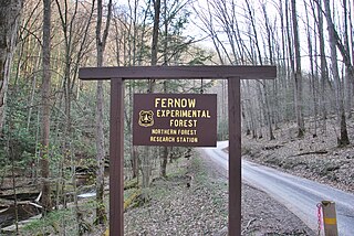
Fernow Experimental Forest is a research forest in Tucker County, West Virginia. It is operated by the U.S. Forest Service's Northern Research Station. It is named for Bernhard Fernow, a prominent forester in the late 19th century and early 20th century.

Brush Mountain East Wilderness is a U.S. wilderness area in the Eastern Divide Ranger District of the George Washington and Jefferson National Forests. It was designated as wilderness area in 2009 by Omnibus Public Land Management Act of 2009. The wilderness is adjacent to Brush Mountain Wilderness.

White Oak Ridge-Terrapin Mountain is a wildland in the George Washington and Jefferson National Forests of western Virginia that has been recognized by the Wilderness Society as a special place worthy of protection from logging and road construction. With over 1200 acres of possible old growth forest, this is a rugged area with a rich diversity of geology and plant life.

North Creek (conservation area) is a wildland in the George Washington and Jefferson National Forests of western Virginia that has been recognized by the Wilderness Society as a special place worthy of protection from logging and road construction. Tall evergreen and hardwood trees in the area around Apple Orchard Falls tower above ferns and wildflowers. The area includes a valley which extends from Sunset Fields in the east to its western border near the North Creek Camping Area.
Cove Mountain is a wildland in the George Washington and Jefferson National Forests of western Virginia that has been recognized by the Wilderness Society as a special place worthy of protection from logging and road construction.
‘Little Dry Run Wilderness Addition is a wildland in the George Washington and Jefferson National Forests of western Virginia that has been recognized by the Wilderness Society as a special place worthy of protection from logging and road construction. The Wilderness Society has designated the area as a "Mountain Treasure".

Mount Rogers Crest Zone is a wildland in the George Washington and Jefferson National Forests of western Virginia that has been recognized by the Wilderness Society as a special place worthy of protection from logging and road construction. The Wilderness Society has designated the area as a "Mountain Treasure".
Little Stony Creek, a wildland in the George Washington and Jefferson National Forests of western Virginia, has been recognized by the Wilderness Society as a special place worthy of protection from logging and road construction. The Wilderness Society has designated the area as a "Mountain Treasure".


