Greenville, Mississippi | |
|---|---|
 | |
 Flag  Seal | |
| Nicknames: The Heart & Soul of the Delta | |
| Motto(s): The Best Food, Shopping, & Entertainment in the South | |
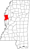
 Location of Greenville in Washington County | |
 Greenville, Mississippi Location in the United States | |
| Coordinates: 33°23′05″N91°02′54″W / 33.38472°N 91.04833°W | |
| Country | United States |
| State | Mississippi |
| County | Washington |
| Incorporated | June 24, 1870 |
| Government | |
| • Type | Municipal government |
| • Mayor | Errick Simmons (D) [1] |
| Area | |
| 27.67 sq mi (71.66 km2) | |
| • Land | 26.90 sq mi (69.66 km2) |
| • Water | 0.77 sq mi (2.00 km2) |
| Elevation | 125 ft (38 m) |
| Population (2020) | |
| 29,670 | |
| • Density | 1,103.2/sq mi (425.95/km2) |
| • Urban | 38,300 |
| Time zone | UTC−6 (CST) |
| • Summer (DST) | UTC−5 (CDT) |
| ZIP codes | 38701–38704, 38731 |
| Area code | 662 |
| FIPS code | 28-29180 |
| GNIS feature ID | 2403752 [3] |
| Website | www.greenvillems.org |
Greenville is the ninth-most populous city in the U.S. state of Mississippi, and the largest city by population in the Mississippi Delta region. It is the county seat of Washington County. The population was 29,670 at the 2020 Census.
Contents
- History
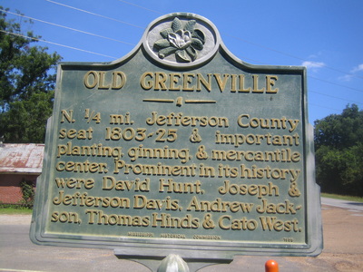
- Early history
- The destruction of Greenville and the Civil War
- Nelson Street
- 21st century
- Geography
- Climate
- Demographics
- 2020 census
- 2013 ACS
- 2000 census
- 1990 census
- Government
- Transportation
- Air
- Transportation 2
- Rail
- Economy
- Education
- Media
- Sports
- Sites
- In popular culture
- Notable people
- Born in Greenville
- Greenville-related
- Sister cities
- See also
- References
- External links


