Carrollton, Mississippi

Last updated

Carrollton, Mississippi
CarrolltonMSWelcomeSign.jpg
Carroll County Mississippi Incorporated and Unincorporated areas Carrollton Highlighted.svg
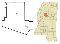
Location of Carrollton, Mississippi
Coordinates: 33°30′18″N89°55′22″W / 33.50500°N 89.92278°W / 33.50500; -89.92278
Country United States
State Mississippi
County Carroll
Area
[1]
  Total0.81 sq mi (2.11 km2)
  Land0.81 sq mi (2.11 km2)
  Water0.00 sq mi (0.00 km2)
Elevation
289 ft (88 m)
Population
 (2020)
  Total423
  Density520.30/sq mi (200.92/km2)
Time zone UTC-6 (Central (CST))
  Summer (DST) UTC-5 (CDT)
ZIP code
38917
Area code 662
FIPS code 28-11580
GNIS feature ID0668097
Website www.carrolltonms.com

Carrollton is a town in and the second county seat of Carroll County, Mississippi, United States, which is within the Mississippi Delta. The population was 190 at the 2010 census, [2] down from 408 in 2000. Centrally located in the county, the town is part of the Greenwood, Mississippi micropolitan area. The first county seat, Vaiden, was founded in the eastern part of the county during its early settlement.

Contents

History

The town was developed as the county seat and trading center for rural Carroll County, which was devoted to cotton agriculture and plantations in the antebellum era.

The town was the location of the Carroll County Courthouse Massacre, in 1886. [3]

Geography

Carrollton is located in central Carroll County on the south side of Big Sand Creek, a tributary of the Yalobusha River. According to the United States Census Bureau, Carrollton has a total area of 0.8 square miles (2.1 km2), all land.

The town borders North Carrollton, which is located directly to the north across the creek. Mississippi Highways 17 and 35 pass through the center of Carrollton, leading north into North Carrollton. Many residents of Carrollton and North Carrollton consider the towns a single entity, simply referred to as Carrollton. [4]

Highway 35 continues north 21 miles (34 km) to Holcomb; in the other direction, it leads southeast 18 miles (29 km) to Vaiden, the other county seat. Highway 17 leads south 30 miles (48 km) to Lexington. U.S. Route 82, a four-lane divided highway, passes through the southern part of Carrollton, leading east 11 miles (18 km) to Winona and west 18 miles (29 km) to Greenwood.

Climate

The climate in this area is characterized by hot, humid summers and generally mild to cool winters. According to the Köppen Climate Classification system, Carrollton has a humid subtropical climate, abbreviated "Cfa" on climate maps. [5]

Demographics

Historical population
CensusPop.Note
1860 718
1870 377−47.5%
1880 3944.5%
1890 48823.9%
1900 54010.7%
1910 60812.6%
1920 510−16.1%
1930 5232.5%
1940 5759.9%
1950 475−17.4%
1960 343−27.8%
1970 295−14.0%
1980 33814.6%
1990 221−34.6%
2000 40884.6%
2010 190−53.4%
2020 423122.6%
U.S. Decennial Census [6]
Unveiling of Confederate monument in Carrollton, 1905 Unveiling of Confederate monument in Carrollton, Mississippi - 1905.jpg
Unveiling of Confederate monument in Carrollton, 1905

2020 census

Carrollton racial composition
(NH = Non-Hispanic) [7] [lower-alpha 1]
RaceNumberPercentage
White (NH)29369.27%
Black or African American (NH)10825.53%
Native American or Alaska Native (NH)10.24%
Mixed/Multi-Racial (NH)61.42%
Hispanic or Latino 153.55%
Total423

As of the 2020 United States census, there were 423 people, 73 households, and 43 families residing in the town.

2000 census

As of the census [9] of 2000, there were 408 people, 85 households, and 62 families residing in the town. The population density was 522.0 inhabitants per square mile (201.5/km2). There were 99 housing units at an average density of 126.7 per square mile (48.9/km2). The racial makeup of the town was 50.00% White and 50.00% African American. Hispanic or Latino of any race were 0.49% of the population.

There were 85 households, out of which 24.7% had children under the age of 18 living with them, 57.6% were married couples living together, 10.6% had a female householder with no husband present, and 25.9% were non-families. 24.7% of all households were made up of individuals, and 17.6% had someone living alone who was 65 years of age or older. The average household size was 2.27 and the average family size was 2.65.

In the town, the population was spread out, with 8.3% under the age of 18, 27.9% from 18 to 24, 34.3% from 25 to 44, 18.1% from 45 to 64, and 11.3% who were 65 years of age or older. The median age was 31 years. For every 100 females, there were 312.1 males. For every 100 females age 18 and over, there were 340.0 males.

The median income for a household in the town was $48,750, and the median income for a family was $53,333. Males had a median income of $21,667 versus $23,750 for females. The per capita income for the town was $13,536. About 6.9% of families and 6.5% of the population were below the poverty line, including 8.3% of those under age 18 and 10.6% of those age 65 or over.

Education

The town of Carrollton is served by the Carroll County School District. Its schools are Marshall Elementary School and J. Z. George High School in North Carrollton.

It is also served by Carroll Academy, a private school in Carrollton.

Notable people

Notes

  1. Note: the US Census treats Hispanic/Latino as an ethnic category. This table excludes Latinos from the racial categories and assigns them to a separate category. Hispanics/Latinos can be of any race. [8]

Related Research Articles

<span class="mw-page-title-main">Carroll County, Mississippi</span> County in Mississippi, United States

Carroll County is a county in the U.S. state of Mississippi. As of the 2020 census, the population was 9,998. Its county seats are Carrollton and Vaiden. The county is named for Charles Carroll of Carrollton, the last surviving signatory of the Declaration of Independence.

<span class="mw-page-title-main">Carroll County, Iowa</span> County in Iowa, United States

Carroll County is a county located in the U.S. state of Iowa. As of the 2020 census, the population was 20,760. Its county seat is Carroll. The county is named in honor of Charles Carroll of Carrollton, signer of the Declaration of Independence.

<span class="mw-page-title-main">Alpena, Arkansas</span> Town in Arkansas, United States

Alpena is a town in Boone and Carroll counties in the U.S. state of Arkansas. The population was 374 at the 2020 census.

<span class="mw-page-title-main">Carroll, Iowa</span> City in Iowa, United States

Carroll is a city in, and the county seat of, Carroll County, Iowa, United States, along the Middle Raccoon River. The population was 10,321 in the 2020 census.

<span class="mw-page-title-main">Carrollton, Kentucky</span> City in Kentucky, United States

Carrollton is a home rule-class city in—and the county seat of—Carroll County, Kentucky, United States, at the confluence of the Ohio and Kentucky rivers. The population was 3,938 at the 2010 census.

<span class="mw-page-title-main">New Carrollton, Maryland</span> City in Maryland, United States

New Carrollton is a city located in central Prince George's County, Maryland, United States. As of the 2020 census, the population was 13,715. New Carrollton is located 10 miles (16 km) east of central Washington, D.C.

<span class="mw-page-title-main">Ashland, Mississippi</span> Town in Mississippi, United States

Ashland is a town in Benton County, Mississippi, United States and the county seat. The population was 551 at the 2020 census, down from 569 at the 2010 census. Ashland was incorporated on March 8, 1871, and has a Mayor-Aldermen form of government. Mitch Carroll is the 28th mayor of Ashland.

<span class="mw-page-title-main">Hickory Flat, Mississippi</span> Town in Mississippi, United States

Hickory Flat is a town in Benton County, Mississippi, United States. The population was 601 at the 2010 census.

<span class="mw-page-title-main">North Carrollton, Mississippi</span> Town in Mississippi, United States

North Carrollton is a town in Carroll County, Mississippi, United States. The population was 473 at the 2010 census. It is part of the Greenwood, Mississippi micropolitan area.

<span class="mw-page-title-main">Vaiden, Mississippi</span> Town in Mississippi, United States

Vaiden is a town in Carroll County, Mississippi, United States and its first county seat. The population was 734 at the 2010 census. It is part of the Greenwood, Mississippi micropolitan area.

<span class="mw-page-title-main">Pachuta, Mississippi</span> Town in Mississippi, United States

Pachuta is a town in Clarke County, Mississippi, United States. The population was 261 at the 2010 census.

<span class="mw-page-title-main">Pickens, Mississippi</span> Town in Mississippi, United States

Pickens is a town in Holmes County, Mississippi, United States. Per the 2020 census, the population was 920.

<span class="mw-page-title-main">West, Mississippi</span> Town in Mississippi, United States

West is a town in northeastern Holmes County, Mississippi, United States. Per the 2020 census, the population was 153. The Mayor of West, MS as of December 2020 is Michael Fancher.

<span class="mw-page-title-main">Montrose, Mississippi</span> Town in Mississippi, United States

Montrose is a town in Jasper County, Mississippi, United States. The population was 140 at the 2010 census.

<span class="mw-page-title-main">Lula, Mississippi</span> Town in Mississippi, United States

Lula is a town in Coahoma County, Mississippi, United States. Per the 2020 census, the population was 204.

<span class="mw-page-title-main">Carrollton, Ohio</span> Village in Ohio, United States

Carrollton is a village in and the county seat of Carroll County, Ohio, located 22 miles (35 km) southeast of Canton. The population was 3,087 at the time of the 2020 census. It is part of the Canton–Massillon metropolitan area.

<span class="mw-page-title-main">Paducah, Texas</span> Town in Texas, United States

Paducah is a town in Cottle County, Texas, United States. The population was 1,186 at the 2010 census, down from 1,498 in 2000. It is the county seat of Cottle County. It is just south of the Texas Panhandle and east of the Llano Estacado.

<span class="mw-page-title-main">Dickens, Texas</span> City in Texas, United States

Dickens is a city in and the county seat of Dickens County, Texas, United States. The population was 286 at the 2010 census, down from 332 at the 2000 census.

<span class="mw-page-title-main">State Line, Mississippi</span> Town in Mississippi, United States

State Line is a town in Greene and Wayne counties, Mississippi, in the United States. The population was 452 at the 2020 census.

<span class="mw-page-title-main">Greenwood, Mississippi micropolitan area</span>

The Greenwood Micropolitan Statistical Area is a micropolitan area in the northwestern Delta region of Mississippi that covers two counties - Leflore and Carroll. As of the 2000 census, the USA had a population of 48,716.

References

  1. "2020 U.S. Gazetteer Files". United States Census Bureau. Retrieved July 24, 2022.
  2. "Geographic Identifiers: 2010 Demographic Profile Data (G001): Carrollton town, Mississippi". U.S. Census Bureau, American Factfinder. Archived from the original on February 12, 2020. Retrieved October 2, 2014.
  3. https://blackthen.com/mississippi-massacre-cold-case-1886-senseless-murders-for-the-spill-of-molasses-on-a-white-man/
  4. "MSU First Impressions Report". Mscat.msstate.edu. June 30, 2010. Archived from the original on June 12, 2010. Retrieved July 1, 2010.
  5. Climate Summary for Carrollton, Mississippi, Weatherbase.com
  6. "Census of Population and Housing". Census.gov. Retrieved June 4, 2015.
  7. "Explore Census Data". data.census.gov. Retrieved March 5, 2022.
  8. "About the Hispanic Population and its Origin". www.census.gov. Retrieved May 18, 2022.
  9. "U.S. Census website". United States Census Bureau . Retrieved January 31, 2008.