Mendenhall, Mississippi | |
---|---|
Coordinates: 31°57′40″N89°52′3″W / 31.96111°N 89.86750°W | |
Country | United States |
State | Mississippi |
County | Simpson |
Government | |
• Type | Mayor-Council |
• Mayor | Todd Booth |
• Board of Aldermen | Donnie Thomas Robert Mangum Jana Miller Sandra Weeks Tim Gray |
Area | |
• Total | 5.36 sq mi (13.89 km2) |
• Land | 5.35 sq mi (13.85 km2) |
• Water | 0.01 sq mi (0.03 km2) |
Elevation | 335 ft (102 m) |
Population (2020) | |
• Total | 2,199 |
• Density | 411.18/sq mi (158.74/km2) |
Time zone | UTC−6 (Central (CST)) |
• Summer (DST) | UTC−5 (CDT) |
ZIP code | 39114 |
Area code | 601 |
FIPS code | 28-46600 |
GNIS feature ID | 0673476 |
Website | ci |
Mendenhall is a city in Simpson County, Mississippi, United States. The population was 2,504 at the 2010 census. It is the county seat of Simpson County. [2] Mendenhall is part of the Jackson Metropolitan Statistical Area. Mendenhall has one of the highest trained volunteer fire depts in the area. Mendenhall has 1 full-time fire marshall. Of the 30 members 17 are NFPA 1001 Base certified, 2 are NFPA 1001-2 certified, 1 paramedic and 8 emt's, 4 are first responder certified. Mendenhall has 3 class A pumpers with 1 being a dual purpose engine that has equipment for rescue and medical calls, 1 3,000 gallon tanker, 1 custom brush truck. Mendenhall carries a class 6 fire rating.
Mendenhall was originally called Edna, to honor the wife of developer Phillip Didlake. After learning that a town with that name already existed in Mississippi, the city had its name changed to Mendenhall to honor Thomas Mendenhall, a citizen and lawyer from Westville, Mississippi (which has become a ghost town). [3]
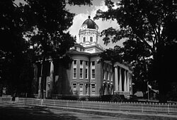
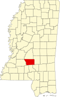
Mendenhall is the county seat of Simpson County. The county courthouse was built in 1907 [4] by architect Andrew J. Byron. [4]
The Mendenhall Public School mascot is the Tigers. [5] Also located in Mendenhall is Simpson County Academy. [6] The school mascot is the Cougars. [7] Mendenhall's zip code is 39114. [8]
Weathersby was an unincorporated census-designated community 2.7 miles (4.3 km) southeast of Mendenhall, and 7.4 miles (11.9 km) northeast of Magee. According to Charles Baldwin, Simpson County Tax Collector, Mendenhall annexed Weathersby in the 1980s.
B & B Meat Market and Deli is located in Mendenhall and has been awarded "Best Burger in Mississippi" by the Mississippi Beef Council in 2017 and 2019. [9]
According to the United States Census Bureau, the city has a total area of 5.3 square miles (14 km2), of which 5.3 square miles (14 km2) is land and 0.04 square miles (0.10 km2) (0.37%) is water.
Census | Pop. | Note | %± |
---|---|---|---|
1910 | 606 | — | |
1920 | 637 | 5.1% | |
1930 | 919 | 44.3% | |
1940 | 1,282 | 39.5% | |
1950 | 1,539 | 20.0% | |
1960 | 1,946 | 26.4% | |
1970 | 2,402 | 23.4% | |
1980 | 2,533 | 5.5% | |
1990 | 2,463 | −2.8% | |
2000 | 2,555 | 3.7% | |
2010 | 2,504 | −2.0% | |
2020 | 2,199 | −12.2% | |
U.S. Decennial Census [10] |
Num. | Perc. | |
---|---|---|
White (non-Hispanic) | 1,348 | 61.3% |
Black or African American (non-Hispanic) | 743 | 33.79% |
Native American | 2 | 0.09% |
Asian | 3 | 0.14% |
Other/Mixed | 74 | 3.37% |
Hispanic or Latino | 29 | 1.32% |
As of the 2020 United States census, there were 2,199 people, 1,024 households, and 641 families residing in the city.
This section relies largely or entirely on a single source .(December 2017) |
Mendenhall had a movie theatre called the Star Theatre, [12] built by Edgar French, Ben Slay and Lonnie Burnham. Located on Main Street, the building boasted a one-screen auditorium with a balcony. It also featured a pool hall and three offices upstairs, one of which housed the city's Chamber of Commerce. The theatre opened for business on November 9, 1938 with the western Born to the West. The price of admission was 11 cents and a box of popcorn was a dime. A man from Prentiss was initially hired to run the theatre, but he was soon "sent packing" and Edgar French told his son, George Lewis French, "You're taking over that picture show".
Lewis French, who had worked in his father's ice plant growing up and was trained as a bookkeeper at Clarks Commercial College in Jackson, had no experience in running a movie theatre. He went to New Orleans to learn how to book movies and run the projection equipment. Aside from time spent serving in Europe as a radio man during World War II, French continued to operate the Star Theatre until he decided to close it in 1971. [13]
During the late 1960s, the Star Theatre had problems with vandalism and growing racial tensions among its young patrons who objected to maintaining segregation. Under Jim Crow customs, black customers were required to sit in the segregated balcony and this only changed after new U.S. legislation was enacted and ended such practices.
In October 1979, a newly remodeled and fully integrated Star Theatre reopened under the ownership of Danny Collins, a young local entrepreneur. Its first movie was the Chuck Norris film A Force of One . The theatre enjoyed revived popularity until competition from video arcades and cable TV forced Collins to close some three years later.
The theatre was repainted when used as a location for the film My Dog Skip . Heavy rains caused the roof to collapse in April 2008. The theatre burned down in 2016.
Simpson County is a county located in the U.S. state of Mississippi. Its western border is formed by the Pearl River, an important transportation route in the 19th century. As of the 2020 census, the population was 25,949. The county seat is Mendenhall. The county is named for Josiah Simpson (1787-1817), a territorial judge who also served as a delegate to Mississippi's Constitutional Convention.
Hinds County is a county located in the U.S. state of Mississippi. With its county seats, Hinds is the most populous county in Mississippi with a 2020 census population of 227,742 residents. Hinds County is a central part of the Jackson metropolitan statistical area. It is a professional, educational, business and industrial hub in the state. It is bordered on the northwest by the Big Black River and on the east by the Pearl River. It is one county width away from the Yazoo River and the southern border of the Mississippi Delta.
Calhoun County is a county located in the U.S. state of Mississippi. As of the 2020 census, the population was 13,266. Its county seat is Pittsboro. The county is named after John C. Calhoun, the U.S. Vice President and U.S. Senator from South Carolina.
Corinth is a city in and the county seat of Alcorn County, Mississippi, United States. The population was 14,573 at the 2010 census. Its ZIP codes are 38834 and 38835. It lies on the state line with Tennessee.
Picayune is the largest city in Pearl River County, Mississippi, United States. The population was 11,885 at the 2020 census. The city is located approximately 45 miles (72 km) from New Orleans, Hattiesburg, and Gulfport–Biloxi. The Stennis Space Center is 10 miles (16 km) away. Picayune is part of the New Orleans–Metairie–Hammond combined statistical area.
Braxton is a village in Simpson County, Mississippi, United States. The village's population was 181 at the 2000 census. It is part of the Jackson, Mississippi Metropolitan Statistical Area. Its zip code is 39044.
Magee is a city in Simpson County, Mississippi, United States. It is part of the Jackson metropolitan area.
Hattiesburg is the 5th most populous city in the U.S. state of Mississippi, located primarily in Forrest County and extending west into Lamar County. The city population was 45,989 at the 2010 census, with the population now being 48,730 in 2020. Hattiesburg is the principal city of the Hattiesburg Metropolitan Statistical Area, which encompasses Covington, Forrest, Lamar, and Perry counties. The city is located in the Pine Belt region.
Mississippi Highway 469 is a state highway in central Mississippi, located in Simpson and Rankin counties. The route starts at MS 28 near Georgetown, and it travels north through western Simpson County. The road enters the community of Harrisville and enters Rankin County soon after. It intersects U.S. Route 49 in Florence, and it ends at MS 468 near Whitfield. The route was designated in 1953, and it was extended southwards to MS 20 in 1956. By 1960, all of the route was paved with asphalt.
Mississippi Highway 43 is a state highway in Mississippi that generally runs north–south in three segments: the first from US 90 near Bay St. Louis to MS 13 south of Columbia, resuming at MS 13 in southern Jefferson Davis County to end near Mendenhall, and finally starting again at MS 18 near Puckett to end at Attala Road 3122 in northern Attala County. It traverses approximately 235 miles (378 km), serving Hancock, Pearl River, Marion, Jefferson Davis, Lawrence, Simpson, Rankin, Madison, Leake, and Attala counties.
Jackson, MS Metropolitan Statistical Area is a metropolitan statistical area (MSA) in the central region of the U.S. state of Mississippi that covers seven counties: Copiah, Hinds, Holmes, Madison, Rankin, Simpson, and Yazoo. As of the 2010 census, the Jackson MSA had a population of 586,320. According to 2019 estimates, the population has slightly increased to 594,806. Jackson is the principal city of the MSA.
Ida is an unincorporated community and census-designated place (CDP) in Monroe County in the U.S. state of Michigan. The CDP had a population of 790 at the 2020 census. The community is mostly within Ida Township with a smaller portion extending north into Raisinville Township.
University is a census-designated place (CDP) and the official name for an area covering a portion of the University of Mississippi campus, in Lafayette County, Mississippi, United States. The CDP is surrounded by the city of Oxford. Its official United States Postal Service designation is "University, Mississippi", with a ZIP Code of 38677.
Moro is an unincorporated community and census-designated place (CDP) in Madison County, Illinois, United States. As of the 2020 census it had a population of 387. Moro, like all of Madison County, is part of the Illinois Metro-East region of the Greater St. Louis metropolitan area.
Mississippi Highway 149 is a state highway in Mississippi. The route designation is given to six former segments of U.S. Route 49, and two former sections of US 49W, within the state that have been bypassed. The sections run through Wiggins, Mount Olive, between Magee and Sanatorium, between Mendenhall and Braxton, in Richland, Mississippi, between Yazoo City and Silver City, Inverness, and Clarksdale. The total length of the eight sections of MS 149 is 58.073 miles (93.459 km).
DeLisle is a census-designated place (CDP) in Harrison County, Mississippi, United States. It is part of the Gulfport–Biloxi Metropolitan Statistical Area. The population was 1,147 at the 2010 census.
Toomsuba is a census-designated place (CDP) and unincorporated community in Lauderdale County, Mississippi, United States. Its population was 778 as of the 2020 census. Its ZIP code is 39364.
Garrison is an unincorporated community and census-designated place in Lewis County, Kentucky, United States. Its population was 866 as of the 2010 census. Garrison has a post office with ZIP code 41141, which opened on February 26, 1886. The community is located along the Ohio River and Kentucky Route 8.
Port Gibson High School is a public high school in unincorporated Claiborne County, Mississippi, with a Port Gibson. It opened in 1924. It is part of the Claiborne County School District. The student body is 99 percent African American. The old Port Gibson High School campus is now used by Port Gibson Middle School and is listed on the National Register of Historic Places.
Mississippi Highway 540 (MS 540) is a state highway through Simpson and Smith counties in central Mississippi. First created in 1958, the highway consists of two segments- one running about 10+1⁄2 miles (16.9 km) from Harrisville to D'Lo and a second 21.7-mile-long (34.9 km) road from Mendenhall to Raleigh.