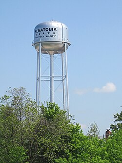
Senatobia, Mississippi | |
---|---|
![]() | |
Motto: The Five Star City | |
![]() Location of Senatobia, Mississippi | |
Coordinates: 34°36′59″N89°59′10″W / 34.61639°N 89.98611°W | |
Country | United States |
State | Mississippi |
County | Tate |
Chartered | 1860 |
Government | |
• Mayor | Greg Graves [1] |
Area | |
• Total | 15.64 sq mi (40.51 km2) |
• Land | 15.56 sq mi (40.30 km2) |
• Water | 0.08 sq mi (0.21 km2) |
Elevation | 279 ft (85 m) |
Population (2020) | |
• Total | 8,354 |
• Density | 536.96/sq mi (207.32/km2) |
Time zone | UTC-6 (Central (CST)) |
• Summer (DST) | UTC-5 (CDT) |
ZIP code | 38668 |
Area code | 662 |
FIPS code | 28-66440 |
GNIS feature ID | 2405443 [3] |
Highways | ![]() ![]() ![]() ![]() |
Website | http://www.cityofsenatobia.com |
Senatobia is a city in and the county seat of Tate County, Mississippi, United States, [4] and is the 16th largest municipality in the Memphis Metropolitan Area. The population was 8,165 at the 2010 census. Senatobia is home to Northwest Mississippi Community College, a state community college providing two-year academic and technical degree programs. Also located in Senatobia is the Baddour Center, a residential care facility for intellectually disabled adults.
On April 13, 1834, early settler James Peters purchased two sections of land from the Chickasaw Nation for the sum of $1.25 per acre. This land was later developed as the town of Senatobia. The community took its name from Senatobia Creek. [5]
The Downtown Senatobia Historic District, the core of Senatobia's central business district developed in 1856 after the opening of the Tennessee and Mississippi Railroad. [6] Two nearby settlements, Tatumsville and Tatesville were both abandoned, with those populations moving to Senatobia in favor of easier transportation. [6]
Senatobia received its charter as a municipality in 1860. During the Civil War, the town's business section was burned twice by Federal troops. Tate County was organized in 1873, during the Reconstruction era, with Senatobia becoming the county seat in 1873 for the newly formed county.
According to the United States Census Bureau, the city has a total area of 10.8 square miles (28 km2), of which 10.8 square miles (28 km2) is land and 0.04 square miles (0.10 km2) (0.28%) is water.
Census | Pop. | Note | %± |
---|---|---|---|
1880 | 935 | — | |
1890 | 1,077 | 15.2% | |
1900 | 1,156 | 7.3% | |
1910 | 1,275 | 10.3% | |
1920 | 1,126 | −11.7% | |
1930 | 1,264 | 12.3% | |
1940 | 1,757 | 39.0% | |
1950 | 2,108 | 20.0% | |
1960 | 3,259 | 54.6% | |
1970 | 4,247 | 30.3% | |
1980 | 5,013 | 18.0% | |
1990 | 4,772 | −4.8% | |
2000 | 6,682 | 40.0% | |
2010 | 8,165 | 22.2% | |
2020 | 8,354 | 2.3% | |
U.S. Decennial Census [7] |
Race | Num. | Perc. |
---|---|---|
White | 4,467 | 53.47% |
Black or African American | 3,367 | 40.3% |
Native American | 10 | 0.12% |
Asian | 31 | 0.37% |
Other/Mixed | 255 | 3.05% |
Hispanic or Latino | 224 | 2.68% |
As of the 2020 United States Census, there were 8,354 people, 2,470 households, and 1,639 families residing in the city.
As of the census [9] of 2010, there were 8,165 people, 2,554 households, and 1,826 families residing in the city, up from 6,682 people, 2,137 households, and 1,498 families recorded in the census of 2000. The population density was 621.7 inhabitants per square mile (240.0/km2). There were 2,239 housing units at an average density of 208.3 per square mile (80.4/km2). The racial makeup of the city was 61.1% non-Hispanic White, 35.0% non-Hispanic African American, 2.4% Hispanic or Latino of any race, and 1.6% in other racial/ethnic categories. In the 2000 census, the distribution had been 68.03% White, 30.51% African American, 0.12% Native American, 0.22% Asian, 0.15% Pacific Islander, 0.24% from other races, and 0.72% from two or more races, while Hispanic or Latino of any race were 0.85% of the population.
There were 2,137 households, out of which 38.3% had children under the age of 18 living with them, 47.4% were married couples living together, 19.4% had a female householder with no husband present, and 29.9% were non-families. 26.6% of all households were made up of individuals, and 12.5% had someone living alone who was 65 years of age or older. The average household size was 2.60 and the average family size was 3.15.
In the city, the population was spread out, with 24.8% under the age of 18, 20.1% from 18 to 24, 26.0% from 25 to 44, 17.1% from 45 to 64, and 11.9% who were 65 years of age or older. The median age was 29 years. For every 100 females, there were 89.1 males. For every 100 females age 18 and over, there were 85.4 males.
The median income for a household in the city was $33,698, and the median income for a family was $43,088. Males had a median income of $34,022 versus $22,000 for females. The per capita income for the city was $16,434. About 13.0% of families and 17.7% of the population were below the poverty line, including 21.3% of those under age 18 and 18.5% of those age 65 or over.
All of Senatobia is within the Senatobia Municipal School District. [10]
There is a private school, Magnolia Heights School.
Franklin County is a county located in the U.S. state of Alabama. As of the 2020 census, the population was 32,113. Its county seat is Russellville. Its name is in honor of Benjamin Franklin, famous statesman, scientist, and printer. It is a dry county, although the city of Russellville is wet.
Lamar County is a county in the U.S. state of Alabama. As of the 2020 census, the population was 13,972. Its county seat is Vernon and it is a dry county. It is named in honor of Lucius Quintus Cincinnatus Lamar, a former Confederate officer and former member of both houses of the United States Congress from Mississippi.
Walthall County is a county located in the U.S. state of Mississippi. As of the 2020 census, the population was 13,884. Its county seat is Tylertown. The county is named after Civil War Confederate general and Mississippi Senator Edward C. Walthall.
Tate County is a county located in the northwestern portion of the U.S. state of Mississippi. As of the 2020 census, the population was 28,064. Its county seat is Senatobia. Organized in 1873 during the Reconstruction era, from portions of DeSoto, Marshall, and Tunica counties, the county is named for Thomas Simpson Tate, one of the first prominent American settlers of the area.
Sharkey County is a county located in the U.S. state of Mississippi. Part of the eastern border is formed by the Yazoo River. According to the 2020 census, the population was 3,800, making it the second-least populous county in Mississippi, after Issaquena County. Its county seat is Rolling Fork. The county is named after William L. Sharkey, the provisional Governor of Mississippi in 1865.
Marshall County is a county located on the north central border of the U.S. state of Mississippi. As of the 2020 census, the population was 33,752. Its county seat is Holly Springs. The county is named for Chief Justice of the United States John Marshall, who presided in the early nineteenth century. Marshall County is part of the Memphis, TN-MS-AR Metropolitan Statistical Area.
Grady is a city in Lincoln County, Arkansas, United States. The population was 305 at the 2020 census, down from 449 at the 2010 census. It is included in the Pine Bluff, Arkansas Metropolitan Statistical Area.
Madison is a city in Madison and St. Clair counties in the U.S. state of Illinois. It is also a suburb of St. Louis. The population was 3,171 at the 2020 census, down from 3,891 in 2010. It is home to World Wide Technology Raceway at Gateway and the first Bulgarian Orthodox church in the United States.
Venice is a city in Madison County, Illinois, United States. The population was 1,498 at the 2020 census, down from 1,890 in 2010.
Hernando is the county seat of DeSoto County, on the northwestern border of Mississippi, United States. The population was 17,138 according to the 2020 census records. It is located on the south side of the Memphis, Tennessee metro area. U.S. Route 51 and the I-55 freeway traverse the city from north to south, and the I-69 freeway crosses the city from east to west. The county courthouse is located within Hernando's historic downtown square. It is located at the intersection of Commerce Street and present-day U.S. 51.
Escatawpa is an unincorporated community and census-designated place (CDP) in Jackson County, Mississippi, United States. It is part of the Pascagoula Metropolitan Statistical Area. The population was 3,254 at the 2020 census.
Falcon is a town in Quitman County, Mississippi. The population was 116 at the 2020 census.
Sledge is a town located in Quitman County, Mississippi, United States. As of the 2020 census, the town had a total population of 368.
Wilson City is a village in Mississippi County, Missouri, United States. The population was 77 at the 2020 census.
Lyon is a town in Coahoma County, Mississippi, United States. Per the 2020 census, the population was 296.
Coldwater is a town in Tate County, Mississippi, United States, and is part of the Memphis Metropolitan Area. The population was 1,677 at the 2010 census.
Valley Hill is an unincorporated community and census-designated place (CDP) in Henderson County, North Carolina, United States. The population was 2,070 at the 2010 census. It is part of the Asheville Metropolitan Statistical Area.
Buna is an unincorporated community and census-designated place (CDP) in Jasper County, Texas, United States. The population was 2,137 at the 2020 census.
Poca is a town in Putnam County, West Virginia, United States. The population was 875 at the 2020 census. It is part of the Huntington–Ashland metropolitan area. The town derives its name from the Pocatalico River.
The Town of Delafield is located in Waukesha County, Wisconsin, United States. The population was 8,095 at the 2020 census. The City of Delafield is adjacent to the town. The unincorporated community of Buena Vista is located in the town.