Related Research Articles

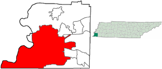
Belle Meade is a city in Davidson County, Tennessee. Its total land area is 3.1 square miles (8.0 km2), and its population was 2,912 at the time of the 2010 census.
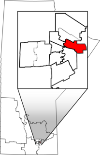
Elmwood—Transcona is a federal electoral district in Manitoba, Canada, that has been represented in the House of Commons of Canada since 1988. Its population in 2011 was 85,906.
Green Hills is a neighborhood in Nashville, Tennessee. Green Hills is located south of downtown Nashville on Hillsboro Pike.
Lenox is a neighborhood in Memphis, Tennessee. It is bounded by Central Avenue in the south, Union Avenue in the north, Cooper Street in the west and East Parkway South in the east.

Chickasaw Gardens is an established upscale neighborhood in midtown Memphis, Tennessee.
State Route 1, known as the Memphis to Bristol Highway, is a 538.8-mile-long (867.1 km) mostly-unsigned state highway in the U.S. state of Tennessee. It stretches all the way from the Arkansas state line at Memphis in the southwest corner of the state to Bristol in the northeast part. Most of the route travels concurrently with U.S. Route 70 and US 11W. It is the longest highway of any kind in the state of Tennessee. The route is signed as both in the state of Tennessee, a Primary and Secondary Highway

High Point Terrace is a neighborhood located in the heart of the city of Memphis, Tennessee. The High Point Terrace Historic District is listed on the National Register of Historic Places.
East Memphis is a region of Memphis, Tennessee with several defined and informal subdivisions and neighborhoods such as Colonial Acres, White Station-Yates, Sherwood Forest, Normal Station, High Point Terrace, Belle Meade, Normandy Meadows, St. Nick, Pleasant Acres, Balmoral, and Ridgeway. The general boundaries are informal:
Grandin is an unincorporated community in Putnam County, Florida, United States. It is located near the State Road 100/County Road 315 intersection. As of the 2000 census, its population was 192.

The Upper Eastside is a neighborhood in Miami, Florida, United States. It is north of Edgewater, east of Little Haiti, south of the village of Miami Shores, and sits on Biscayne Bay. In geographical order from south to north and east to west, it contains the subdivisions of Magnolia Park, Bay Point, Morningside, Bayside, Belle Meade, Shorecrest, and Palm Grove. The MiMo District along Biscayne Boulevard in the area is host to many art galleries, shops and restaurants.
Nutbush is a long-standing neighborhood in northeastern Memphis, Tennessee, United States.
The City of Memphis is located on the eastern bank of the Mississippi River in the southwest corner of the U.S. state of Tennessee. It is the regional hub for a tri-state area of Arkansas, Mississippi and Tennessee.
Sherwood Forest is a neighborhood near the University District in eastern Memphis, Tennessee. It is located south of Normal Station and east of Orange Mound. Its boundaries are: Park Ave. (North), Rhodes Ave. (South), Getwell Rd. (East), S. Highland St., Radford Rd., and S. Prescott St (West). The neighborhood is home to the Sherwood Elementary and Middle Schools. Sherwood Forest is noted for having street names relating to the Robin Hood folklore including Robin Hood Lane, Maid Marion Lane, Friar Tuck Road, Little John Road, Nottingham Place, and Allandale Lane.
Vollintine Hills Historic District is a historic district located in the Midtown area of Memphis, Tennessee, notable for its cohesive collection of 78 post-World War II Minimal Traditional and ranch-style houses built around a former synagogue. "The neighborhood represents the efforts of members of an Orthodox religious group to accommodate their beliefs by developing a synagogue and housing for the congregation within easy walking distance."
Parkway Village is a predominantly African-American community in southeast Memphis, Tennessee, United States. Parkway Village is bounded by Getwell Road and Lamar Avenue on the West, Winchester Road on the South, I-240 on the North, and Mendenhall Road on the East. The former Mall of Memphis was in the Parkway Village community.
Belle Eagle is an unincorporated rural community in Northern Haywood County, Tennessee. Belle Eagle is located seven miles north of Brownsville on Tennessee State Route 54. The Green, Herd, Lee, Lewis, Macon, Mullen, Parks, Taylor, Thornton, Walker, and Williams families were among the early settlers. Some of the land was developed as early as 1820. Much of the area remains in large family farms.

Binghampton is a neighborhood on an edge of Midtown in Memphis, Tennessee. It is named after W. H. Bingham, an Irish immigrant, hotelier, planter, magistrate, politician and entrepreneur who founded a town to the east and slightly north of the Memphis city limits in 1893.
White Station is a neighborhood in the east section of Memphis, Tennessee, United States, and is known for White Station High School.

West Meade is a historic mansion in Nashville, Tennessee, United States.
Selly Park Girls' School is a secondary school located in the Selly Park area of Birmingham, in the West Midlands of England.
References
This article needs additional citations for verification .(April 2008) |


Coordinates: 35°07′39″N89°55′07″W / 35.1275°N 89.9186°W
| | This Shelby County, Tennessee geography–related article is a stub. You can help Wikipedia by expanding it. |