Hernando de Soto Bridge

Last updated

Hernando de Soto Bridge
HernandoDeSoto Bridge Pyramid.jpg
Hernando de Soto Bridge photographed from the Memphis Pyramid
Coordinates 35°09′10″N90°03′50″W / 35.15278°N 90.06389°W / 35.15278; -90.06389
Carries6 lanes of I-40.svg I-40
Crosses Mississippi River
Locale Memphis, Tennessee, and West Memphis, Arkansas
Other name(s)The M Bridge, Memphis Bridge, Mississippi Bridge, New Bridge
Maintained by TDOT and ARDOT
ID number 79I00400001
Characteristics
Design tied arch, through arch
MaterialSteel
Pier constructionConcrete
Total length9,432.6 feet (2,875 m)
Width90 feet (27 m)
Longest span900 feet (274 m)
Clearance below 109 feet (33 m)
History
Construction startMay 2, 1967;56 years ago (1967-05-02)
OpenedAugust 2, 1973;50 years ago (1973-08-02)
Statistics
Daily traffic 37,308 (2018) [1]
Location
Hernando de Soto Bridge

The Hernando de Soto Bridge is a tied-arch bridge carrying Interstate 40 across the Mississippi River between West Memphis, Arkansas, and Memphis, Tennessee. The design is a continuous cantilevered cable-stayed steel through arch, with bedstead endposts. Memphians also call the bridge the "New Bridge", [2] as it is newer than the Memphis & Arkansas Bridge (carrying Interstate 55) downstream, and the "M Bridge", due to its distinctive shape. It is of similar construction to the Sherman Minton Bridge between Louisville, Kentucky, and New Albany, Indiana (except that it consists of a single level deck).

Contents

History

Preliminary planning for the river crossing began in 1960 as part of Interstate 40 alignment studies for the Memphis - Little Rock corridor, which was constructed in segments between 1963 and 1968. Before the Hernando de Soto Bridge was completed, traffic going across the river was carried across the Mississippi River by the Interstate 55/US Highway 64/70/79/61 Memphis & Arkansas Bridge crossing, located 2 miles (3.2 km) southwest.

The two states initially feuded over the cost of paying for the bridge. Tennessee officials believed that both states should equally pay for the bridge, while Arkansas officials wanted Tennessee to shoulder a much larger share of the cost due to Tennessee's larger population. Both states eventually agreed to a compromise where Tennessee funded 60% of the cost and Arkansas the remaining 40%. [3] Both states also initially disagreed on the design of the bridge; the original design called for longer through arches and a lower vertical clearance. [3]

Construction of the Hernando de Soto Bridge began on May 2, 1967. [4] Initially planned for completion in 1971, the project experienced multiple delays. [3] The double-arch bridge was opened to automobile traffic on August 2, 1973. [4] [5] A dedication ceremony for the bridge occurred on August 17, 1973. [6] Initially expected to be only $12 million (equivalent to $77.5 million in 2024 [7] ), the final price tag was approximately $57 million (equivalent to $288 million in 2024 [7] ). [6]

The bridge is named for 16th century Spanish explorer Hernando de Soto, who explored this stretch of the Mississippi River and died south of Memphis. [8]

Bridge illumination

Hernando de Soto Bridge illuminated at night in 2015 HernandoDeSotoBridge at Night.jpg
Hernando de Soto Bridge illuminated at night in 2015

At night, the bridge was illuminated by 200 sodium vapor lights along its "M" structure. The bridge was first illuminated on September 5, 1986, after $373,000 of private funds had been raised to fund the cost and installation of the lights. Due to some river traffic having issues with the lights at night reflecting on the water, the city installed a remote switch to toggle the lights on and off briefly while the vessel passes under the bridge. [9] During the 2011 Mississippi River floods, the bridge became dark for about 2 months because the transformers that supply the electricity for the lights were removed to prevent damage to them by flood waters. The bridge was re-lit in a ceremony which occurred on June 21, 2011.

It was announced after the opening of the Big River Crossing along the Harahan Bridge to the south that the existing sodium vapor lights along the Hernando Desoto Bridge would be replaced with a new LED lighting display, thus making the Hernando de Soto Bridge the second bridge over the Mississippi River to be lit as such after the Harahan. The new display can be lit in sync with the Harahan Bridge and display various color patterns dependent upon special occasions or requests. Both displays have been created under an initiative called "Mighty Lights." The $14 million privately funded project was completed in 2018. [10]

Seismic retrofit project

View from the river in 2022 Hernando de Soto Bridge 2022d.jpg
View from the river in 2022

Between 2000 and 2015, the bridge underwent a seismic retrofitting project, allowing it to withstand a 7.7 magnitude earthquake, the similar magnitude of earthquakes during the 1811–12 New Madrid earthquakes. The retrofit project is also a means to protect the bridge as it is located within 100 miles (161 km) of the New Madrid Seismic Zone and serves as a major cargo route and traffic thoroughfare across the river. As part of this project, the main span, approaches, and ramps for the downtown exit were retrofitted. A bridge about 1 mile (1.6 km) west of the main span was rebuilt with earthquake considerations in mind. The federal government covered 80% of the cost, with Tennessee contributing 12% and Arkansas 8%. [11]

Incidents

Aerial shot of the beam fracture, taken May 11, 2021 Hernando de Soto Bridge May 2021 fracture.jpg
Aerial shot of the beam fracture, taken May 11, 2021

On August 23, 2007, an inspector discovered that a bridge pier on the approach bridge west of the river had settled overnight, and the bridge was subsequently closed to perform a precautionary inspection. The bridge was reopened later that day. [12]

On May 11, 2021, an inspection discovered a partially fractured tie girder on the Span A North truss. [13] Two of the four plates comprising the box-shaped tension tie member were completely fractured and the bottom plate was partially fractured, leaving only the inside-facing plate intact. Since the severely compromised girder was one of a pair of load-bearing tension members that were critical to the structural integrity of the bridge's tied-arch design, the bridge was structurally unsound and at risk of collapse. The inspecting engineer called 9-1-1 and told authorities to shut down the bridge immediately. [14] Vehicular traffic across the bridge and river traffic under the bridge were halted while engineers inspected the entire bridge for other issues, and analyzed the structure. [15]

River traffic under the bridge resumed three days later on May 14. Initial repairs that affixed steel plates on both sides of the affected girder were completed on May 25. [16] The second phase consisted of the installation of additional steel plating and removal of part of the damaged beam. [17] A new inspection of the bridge found "nothing of concern". [18] The eastbound lanes reopened on July 31, 2021, [19] the westbound lanes on August 2, 2021. [20] During the closure, vehicle traffic utilized the nearby Memphis & Arkansas Bridge (I-55) as an alternate route in the Memphis area, as well as the Caruthersville Bridge (I-155) to the north and the Helena Bridge (US 49) to the south as alternates elsewhere in the Mid-South. [21] [22]

Investigators received amateur photos taken from the river below as early as 2016 that already showed damage at the same site. [23] And according to the Arkansas Department of Transportation, review of archived drone footage taken during a May 2019 bridge inspection, two years before the damage was discovered, also showed the fracture. [24] The department further found that the mandated hands-on—that is, within arm's length—inspections that should have occurred every two years had not been undertaken. [25] [26] The responsible inspector was subsequently fired. [26] [27]

An engineering analysis revealed the fracture was the result of two particularly wide and poorly done weld repairs in the same spot during "fabrication" (construction) that, along with other poor welds elsewhere on the bridge, had been identified and repaired; there were consequently no further concerns. [28] Key findings of the report included the following four points:

• Metallographic examination of the fracture surfaces identified two weld repairs from fabrication that were much wider and contained weld metal deposit sequencing that differed from other side plate thickness transition welds in the bridge.

• The weld repairs caused two large hydrogen cracks as a result of the inherent restraint, improper preheat and/or use of contaminated welding electrodes commonly associated with weld repairs performed without a fracture control plan.
[....]
• Other hydrogen cracks were identified on the interior tie girder surface at similar thickness transitions throughout the bridge. These hydrogen cracks were comparatively shallow (<3/16 in.), and those observed cracks tended to travel as intergranular cracks through the GCHAZ [grain coarsened heat affected zone] until they arrested in material with lower hardness and greater toughness and hydrogen tolerance.
[....]
• Given the 48-year service life of this structure, the fact that the subject fracture occurred in three separate phases over several years, the recent inspection efforts to identify welding defects at the tie girder thickness transition welds, and no evidence of observed fatigue crack growth during this study, it is highly unlikely that an additional major fracture of a similar tie girder thickness transition weld will occur.
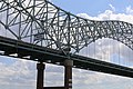
See also

Related Research Articles

<span class="mw-page-title-main">Memphis, Tennessee</span> City in Tennessee, United States

Memphis is a city in the U.S. state of Tennessee. It is the seat of Shelby County, in the southwesternmost part of the state, and is situated along the Mississippi River. With a population of 633,104 at the 2020 U.S. census, Memphis is the second-most populous city in Tennessee after Nashville.

<span class="mw-page-title-main">Interstate 40</span> Interstate Highway across south-central US

Interstate 40 (I-40) is a major east–west transcontinental Interstate Highway in the southeastern and southwestern portions of the United States. At a length of 2,556.61 miles (4,114.46 km), it is the third-longest Interstate Highway in the country, after I-90 and I-80. From west to east, it passes through California, Arizona, New Mexico, Texas, Oklahoma, Arkansas, Tennessee, and North Carolina. Its western end is at I-15 in Barstow, California, while its eastern end is at a concurrency with U.S. Route 117 (US 117) and North Carolina Highway 132 (NC 132) in Wilmington, North Carolina. Major cities served by the interstate include Flagstaff, Arizona; Albuquerque, New Mexico; Amarillo, Texas; Oklahoma City, Oklahoma; Little Rock, Arkansas; Memphis, Nashville, and Knoxville in Tennessee; and Asheville, Winston-Salem, Greensboro, Durham, Raleigh, and Wilmington in North Carolina.

<span class="mw-page-title-main">DeSoto County, Mississippi</span> County in Mississippi, United States

DeSoto County is a county located on the northwestern border of the U.S. state of Mississippi. As of the 2020 census, the population was 185,314, making it the third-most populous county in Mississippi. Its county seat is Hernando.

<span class="mw-page-title-main">West Memphis, Arkansas</span> City in Arkansas, United States

West Memphis is the largest city in Crittenden County, Arkansas, United States. The population was 26,245 at the 2010 census, ranking it as the state's 18th largest city, behind Bella Vista. It is part of the Memphis metropolitan area, and is located directly across the Mississippi River from Memphis, Tennessee.

<span class="mw-page-title-main">Hernando, Mississippi</span> City in Mississippi, United States

Hernando is a city in, and the county seat of, DeSoto County, which is on the northwestern border of Mississippi, United States. The population was 17,138 according to the 2020 census records. DeSoto County is the second-most-populous county in the Memphis metropolitan area, which includes counties in Tennessee, Arkansas and Mississippi.

<span class="mw-page-title-main">Fred Schwengel Memorial Bridge</span> Bridge in Iowa and Rapids City, Illinois

The Fred Schwengel Memorial Bridge is a 4-lane steel girder bridge that carries Interstate 80 across the Mississippi River between LeClaire, Iowa and Rapids City, Illinois. The bridge is named for Fred Schwengel, a former U.S. Representative from Davenport, Iowa and one of the driving forces behind the Interstate Highway Act. The structure was designed by the Iowa State Highway Commission, and was built by the Industrial Construction Company of Minneapolis (contractor), Gould Construction Company of Davenport, and Roy Ryan & Sons of Evanston, Indiana who was responsible for the substructure. The bridge opened on October 27, 1966, and is maintained by the Illinois Department of Transportation. It underwent a major rehabilitation project in 1996.

<span class="mw-page-title-main">Downtown Memphis, Tennessee</span>

Downtown Memphis, Tennessee is the central business district of Memphis, Tennessee and is located along the Mississippi River between Interstate 40 to the north, Interstate 55 to the south and I-240 to the east, where it abuts Midtown Memphis.

<span class="mw-page-title-main">Memphis metropolitan area</span> Combined statistical area in the United States

The Memphis–Clarksdale-Forrest City Combined Statistical Area, TN–MS–AR (CSA) is the commercial and cultural hub of the Mid-South or Ark-Miss-Tenn. The census-defined combined statistical area covers eleven counties in three states, Tennessee, Mississippi, and Arkansas. As of 2020 census, the Memphis metropolitan area had a population of 1,389,905 The Forrest City, Arkansas Micropolitan area was added to the Memphis area in 2012 to form the Memphis–Forrest City Combined Statistical area. In 2023 the Clarksdale, Mississippi Micropolitan area was also added to form the new Memphis-Clarksdale-Forrest City Combined Statistical Area which as of 2023 had a population of roughly 1.4 million people according to census estimates.

<span class="mw-page-title-main">Interstate 269</span> Highway in Mississippi and Tennessee

Interstate 269 (I-269) is a beltway around the city of Memphis, Tennessee, and its adjacent suburban areas in southwestern Tennessee and northern Mississippi, completed in October 2018. I-269 was planned and built to serve as an outer bypass for the Memphis metropolitan area, funneling through traffic around the metro area while also functioning as a bypass of future I-69, which will run directly through the center of the metro area. I-269 currently connects to its parent route, I-69, at an interchange in Hernando, Mississippi, and will do so again in Millington, Tennessee, in the future.

<span class="mw-page-title-main">Memphis & Arkansas Bridge</span> Highway bridge in Memphis, Tennessee, United States

The Memphis & Arkansas Bridge, also known as the Memphis–Arkansas Bridge or inaccurately as the Memphis–Arkansas Memorial Bridge, is a cantilevered through truss bridge carrying Interstate 55 across the Mississippi River between West Memphis, Arkansas and Memphis, Tennessee. Memphians refer to this bridge as the "Old Bridge" to distinguish it from the "New Bridge", or Hernando de Soto Bridge, upstream.

<span class="mw-page-title-main">Frisco Bridge</span> Bridge in Arkansas and Memphis, Tennessee

The Frisco Bridge, previously known as the Memphis Bridge, is a cantilevered through truss bridge carrying a rail line across the Mississippi River between West Memphis, Arkansas, and Memphis, Tennessee.

<span class="mw-page-title-main">Harahan Bridge</span> Bridge between Arkansas and Tennessee, US

The Harahan Bridge is a cantilevered through truss bridge that carries two rail lines and a pedestrian bridge across the Mississippi River between West Memphis, Arkansas, and Memphis, Tennessee. The bridge is owned and operated by Union Pacific Railroad and is the second longest pedestrian/bicycle bridge in the United States. It was built with roadways cantilevered off the sides of the main structure for vehicles. These roadways are owned by the cities of Memphis, Tennessee, and Crittenden County, Arkansas, and were used from 1917–1949, until the Memphis & Arkansas Bridge opened 400 feet (120 m) south of the Harahan. The bridge was named in honor of railroad executive James Theodore Harahan, former president of the Illinois Central Railroad, who was killed in a railroad accident during the construction of the bridge. In February 2011, Union Pacific Railroad officials agreed to the idea of converting the 1917 roadways into a bicycle-pedestrian walkway across the river. In June 2012, Memphis was awarded a $14.9 million federal grant to build the walkway. The overall project was expected to cost $30 million, of which about $11 million was used for the Harahan Bridge portion. Construction was completed in 2016.

<span class="mw-page-title-main">Sherman Minton Bridge</span> Double-deck through arch bridge spanning the Ohio River at Louisville, carrying I-64

The Sherman Minton Bridge is a double-deck through arch bridge spanning the Ohio River, carrying I-64 and US 150 over the river between Kentucky and Indiana. The bridge connects the west side of Louisville, Kentucky to downtown New Albany, Indiana.

<span class="mw-page-title-main">Memphis Suspension Railway</span> Suspended monorail in Memphis, Tennessee, US

The Memphis Suspension Railway, Mud Island Monorail, or Memphis Monorail was a suspended monorail that connects the city center of Memphis with the entertainment park on Mud Island. Celebrating its grand opening on July 3, 1982, it was located beneath a footbridge over the Wolf River Lagoon connecting to the southern tip of Mud Island. In 2018, multiple malfunctions occurred during passenger service, one of which required the fire department to attend to stranded passengers, and finally the motor failed.

<span class="mw-page-title-main">Interstate 55 in Tennessee</span> Interstate Highway in Tennessee, United States

Interstate 55 (I-55) is part of the Interstate Highway System that runs 964.25 miles (1,551.81 km) from LaPlace, Louisiana, to Chicago, Illinois. In the State of Tennessee, the Interstate is located entirely within the state's second-largest city of Memphis, running 12.28 miles (19.76 km) from the Mississippi state line in the Whitehaven neighborhood to the Arkansas border across the Mississippi River. Of the six states that the Interstate passes through, the segment in Tennessee is the shortest, as well as the shortest mainline Interstate segment in Tennessee. I-55 serves a number of neighborhoods and industrial areas in the southwestern portion of Memphis, and also provides access to the Memphis International Airport, the second-busiest cargo airport in the world.

<span class="mw-page-title-main">Interstate 40 in Tennessee</span> Interstate Highway in Tennessee, United States

Interstate 40 (I-40) is part of the Interstate Highway System that runs 2,556.61 miles (4,114.46 km) from Barstow, California, to Wilmington, North Carolina. The highway crosses Tennessee from west to east, from the Mississippi River at the Arkansas border to the Blue Ridge Mountains at the North Carolina border. At 455.28 miles (732.70 km), the Tennessee segment of I-40 is the longest of the eight states through which it passes and the state's longest Interstate Highway.

<span class="mw-page-title-main">Interstate 69 in Mississippi</span> Highway in Mississippi

The proposed Interstate 69 (I-69) extension from Indianapolis southwest to Texas currently has a short piece completed in the US state of Mississippi, south of Memphis, Tennessee. The south end is an at-grade intersection with the former route of Mississippi Highway 304 (MS 304) near Tunica Resorts, where MS 713 continues west to U.S. Highway 61 (US 61), and the route continues north to the Mississippi state line. Much of the route overlaps MS 304, which intersects US 61 farther north than MS 713. MS 304 continues east from I-55, connecting to State Route 385 (SR 385) in Tennessee, forming part of the I-269 Memphis outer beltway.

<span class="mw-page-title-main">Transportation in Memphis, Tennessee</span>

Memphis, Tennessee has developed into a major Mid-American commercial and transportation hub because of its location on the Mississippi River and a convergence of numerous rail and highway links. Four rail and highway bridges cross the Mississippi River at Memphis. In addition, Memphis International Airport has become the world's largest airfreight terminal.

<span class="mw-page-title-main">Sam Cooper Boulevard</span> Urban freeway/parkway in Memphis, Tennessee, United States

Sam Cooper Boulevard is an urban highway in Memphis, Tennessee, United States. The more recent western segment of the road follows a parkway design, while the older eastern portion, which was proposed and constructed as a segment of Interstate 40 (I-40), is built as a freeway, without at-grade intersections and traffic lights. The western terminus of Sam Cooper Boulevard is at East Parkway North. At the western termination point of the road there is a short concurrency of East Parkway North with U.S. Route 64 (US 64), US 70, and US 79. From its western end, Sam Cooper Boulevard continues east for 5.8 miles (9.3 km) to reach its eastern terminus at the I-40/I-240 interchange.

<span class="mw-page-title-main">Mississippi River Trail</span> Long-distance bicycle route

The Mississippi River Trail is a designated bicycle and pedestrian trail that traverses the shores of the Mississippi River in the United States. The trail extends from the headwaters at Lake Itasca in Minnesota to near the mouth of the river in Venice, Louisiana. Much of the trail’s 3,000 miles (4,800 km) follows roadways used by motor vehicles, although some of the route is on multi-use trails. The segment in Minnesota has been designated as U.S. Bicycle Route 45, part of the U.S. Bicycle Route System.

References

  1. Tennessee Department of Transportation. "Traffic History". ArcGIS . Esri . Retrieved July 18, 2020.
  2. Teresa R. Simpson (February 17, 2008). "About.com:Memphis:The Mississippi River". About.com. Archived from the original on November 18, 2008. Retrieved November 11, 2008.
  3. 1 2 3 Watts, Micaela A. (June 3, 2021). "A death, a redesign, a funding feud: Story of the road to the Hernando de Soto I-40 bridge". The Commercial Appeal. Memphis. Retrieved June 12, 2021.
  4. 1 2 "Bridge Gets 'Ho-Hum' Opening". The Commercial Appeal. Memphis. August 3, 1973. p. 1-1. Retrieved November 5, 2021 via Newspapers.com.
  5. Kofoed, Richard (August 5, 1973). "Span Rekindles Westward Ho". The Commercial Appeal. Memphis. p. 2-2. Retrieved November 5, 2021 via Newspapers.com.
  6. 1 2 "I-40 Bridge Dedicated After Political Disclaimers". The Tennessean. United Press International. August 18, 1973. p. 7. Retrieved June 17, 2020 via Newspapers.com.
  7. 1 2 Johnston, Louis; Williamson, Samuel H. (2023). "What Was the U.S. GDP Then?". MeasuringWorth. Retrieved November 30, 2023. United States Gross Domestic Product deflator figures follow the Measuring Worth series.
  8. "Tireless Gold-Seeker Gave Name". The Commercial Appeal. Memphis. August 17, 1973. p. 5-A. Retrieved November 5, 2021 via Newspapers.com.
  9. "The Commercial Appeal". The Commercial Appeal. Archived from the original on October 17, 2012. Retrieved April 26, 2018.
  10. Tom Charlier (May 29, 2018). "The Commercial Appeal". The Commercial Appeal. Retrieved May 29, 2018.
  11. "TDOT". www.tdot.state.tn.us. Archived from the original on May 6, 2015. Retrieved April 26, 2018.
  12. Chris Conley; Richard Locker (August 27, 2007). "Bridge reopens after review". The Commercial Appeal. Memphis. Archived from the original on May 17, 2011. Retrieved April 21, 2008.
  13. "I-40 bridge closed indefinitely after the fracture was discovered". WMC Action News 5. May 11, 2021.
  14. Rojas, Rick (May 13, 2021). "'Get People Off': Shutdown Ordered for Cracked Bridge in Memphis". The New York Times . ISSN   0362-4331. Archived from the original on March 24, 2022. Retrieved January 1, 2022.
  15. "I-40 Hernando de Soto bridge over the Mississippi River is closed because of a crack in the bridge". WATN-TV. May 11, 2021.
  16. Testino, Laura (May 25, 2021). "First phase of two-part I-40 bridge repair complete". The Commercial Appeal. Memphis. Retrieved June 11, 2021.
  17. "Interstate 40 Hernando DeSoto Bridge - Timeline". tn.gov. Nashville: Tennessee Department of Transportation. May 17, 2021. Retrieved June 11, 2021.
  18. "Closure of the I-40 Mississippi River Bridge". Arkansas Department of Transportation. Retrieved June 15, 2021.
  19. Finton, Lucas (August 1, 2021). "The Hernando DeSoto Bridge reopens eastbound lanes, 2 days ahead of plans". The Commercial Appeal. Retrieved August 1, 2021.
  20. Burnside, Tina (August 2, 2021). "A vital Memphis bridge shut down since May due to a structural crack has fully reopened". CNN. Retrieved August 3, 2021.
  21. "Potential 'catastrophic event' avoided by routine I-40 bridge inspection, officials say. Reopening timeline unclear". Memphis Commercial Appeal. May 12, 2021.
  22. "Cracked Memphis Bridge Remains Indefinitely Closed, Disrupting Supply Chain". NPR.org. May 12, 2021. Retrieved May 13, 2021.
  23. Peterson, Joyce. "Photos show I-40 bridge damage in 2016". www.wmcactionnews5.com. Retrieved June 15, 2021.
  24. "Drone footage from 2019 reveals I-40 bridge damage, officials confirm". thv11.com. May 14, 2021. Retrieved June 15, 2021.
  25. "Questions and Answers on the National Bridge Inspection Standards 23 CFR 650 Subpart C - National Bridge Inspection Standards - Bridge Inspection - Safety - Bridges & Structures - Federal Highway Administration". www.fhwa.dot.gov. Retrieved January 1, 2022.
  26. 1 2 Paybarah, Azi (May 18, 2021). "Inspector Who Twice Missed Crack in Bridge Is Fired, Arkansas Officials Say". The New York Times. ISSN   0362-4331 . Retrieved January 1, 2022.
  27. Staff, WMC Action News 5. "Inspector who overlooked crack in 2019 bridge inspection terminated, ArDOT says". www.wmcactionnews5.com. Retrieved June 15, 2021.{{cite web}}: CS1 maint: numeric names: authors list (link)
  28. Arkansas Department of Transportation. "I-40 Hernando deSoto Bridge – Fracture Investigation" ( PDF)