Geography of Memphis, Tennessee

Last updated

Location in Shelby County and the state of Tennessee Memphis Shelby.png
Location in Shelby County and the state of Tennessee

The City of Memphis is located on the eastern bank of the Mississippi River in the southwest corner of the U.S. state of Tennessee. It is the regional hub for a tri-state area of Arkansas, Mississippi and Tennessee.

Contents

Shelby County is located over four natural aquifers, one of which is recognized as the "Memphis sand aquifer" or simply as the "Memphis aquifer." This particular water source is stated to contain more than 100 trillion gallons (380 km³) of water.

Memphis has a humid subtropical climate, with four distinct seasons. The summer months are persistently hot and humid due to moisture encroaching from the Gulf of Mexico.

Geography

Memphis is located in southwestern Tennessee at 35°7′3″N89°58′16″W / 35.11750°N 89.97111°W / 35.11750; -89.97111 . [1] The city sits on the eastern bank of the Mississippi River at the site of the 4th Chickasaw Bluff, just south of the mouth of the Wolf River. According to the United States Census Bureau, the city has a total area of 294.8 sq mi (763.4 km2), of which 279.3 sq mi (723.4 km2) is land and 15.4 sq mi (40.0 km2), or 5.24%, is water.

Cityscape

Three bridges over the Mississippi, view from Tom Lee Park (2007) Tom Lee Park.JPG
Three bridges over the Mississippi, view from Tom Lee Park (2007)

The city of Memphis It is the regional hub for a tri-state area of Arkansas, Mississippi and Tennessee. The city center is located on the Mississippi river at the site of the earliest settlements.

Interstate 40 enters the city from the northeast, and loops above the central part of the city, exiting across the Mississippi River and traveling to the west. Interstate 55 approaches the city from the south and connects with Interstate 240 which, along with I-40, creates the Inner Beltway. Interstate 269 is Memphis' Outer Beltway, traveling from Millington to Hernando via Arlington, Collierville, Piperton, and Byhalia. Upon completion, Interstate 69 will enter Memphis from Southaven along I-55. It will continue north on I-240 and then onto I-40, where it will branch off at SR-300 to continue north towards Dyersburg. Interstate 22 will eventually travel along US-78 from Birmingham to just outside Memphis and is expected to be named sometime in 2015.

U.S. Highway 72 leaves the city traveling to the southeast. The west end of U.S. Highway 78 begins in Memphis on Martin Luther King, Jr. Avenue at the intersection of 2nd Street. As it leaves Memphis, US 78 follows Lamar Avenue, historically known as Pidgeon Roost Road for the nestings of passenger pigeons formerly in the vicinity. The east end of U.S. Highway 78 terminates in Charleston, South Carolina.

Tallest buildings

NameStoriesHeight
100 North Main 37430 ft (130 m)
Clark Tower Executive Suites 32400 ft (120 m)
One Commerce Square 31396 ft (121 m)
Sterick Building 31365 ft (111 m)

Current Geographical Boundaries

Memphis has expanded its city limits several times within the past half-century due to annexation. The current boundaries (as of December 2012) are roughly as follows:

An area within those boundaries that has not been annexed by the city of Memphis is a neighborhood known as the Bridgewater area, roughly bounded by I-40 to the north, Germantown Parkway to the east, Shelby Farms to the south and Whitten Road to the west. Memphis did try to annex this area in the mid-2000s but held it off due to an inability to move services into the area.

Per Tennessee law, each county is required to set up urban growth boundaries for it cities. Because of this, Memphis (along with each suburb) has what is known as an annexation reserve that defines the eventual city limits. This annexation reserve includes an area between the Big Creek Drainage Canal up to the southern border of Millington, Tennessee and western border of Bartlett, an area between Lakeland, Arlington, Fayette County, and Collierville, Tennessee, and then a small portion of land south of the Southwind area mentioned above. [2]

Sections and suburbs

The core of Memphis is marked by five major districts, with smaller districts lying within their borders. These are Downtown, Midtown, North Memphis, South Memphis, and East Memphis. In recent decades, the city has expanded further by annexing adjacent territories, so these names can be somewhat misleading to those who are unfamiliar to the area.

Sections and neighborhoods:

Aquifer

Shelby County is located over four natural aquifers, one of which is recognized as the "Memphis sand aquifer" or simply as the "Memphis aquifer". This particular water source, located some 350 to 1100 ft (100 – 330 m) underground, is stated to contain more than 100 trillion gallons (380 km³) of water by Memphis Light, Gas, and Water, which draws, verifies the cleanliness of, and distributes the water to over 250,000 customers. [4]

Furthermore, in the time since the tapping of the well in 1887, the aquifer has only descended 125 ft (38 m), suggesting a reliable water source in Memphis for years to come. [5]

Most Memphians recognize this as their primary water source, and take great regional pride in their possession of the aquifer. This includes protecting it against potential contaminants, as occurred in 2021 with the Byhalia Pipeline protests. Memphis water is notably soft, low in mineral content, and free of toxic substances. [6]

Climate

Memphis
Climate chart (explanation)
J
F
M
A
M
J
J
A
S
O
N
D
 
 
4
 
 
50
33
 
 
4.4
 
 
55
36
 
 
5.2
 
 
64
44
 
 
5.5
 
 
73
53
 
 
5.3
 
 
81
62
 
 
3.6
 
 
89
70
 
 
4.6
 
 
92
74
 
 
2.9
 
 
91
73
 
 
3.1
 
 
85
65
 
 
4
 
 
74
54
 
 
5.5
 
 
63
44
 
 
5.7
 
 
52
35
Average max. and min. temperatures in °F
Precipitation totals in inches
Source: NOAA
Metric conversion
J
F
M
A
M
J
J
A
S
O
N
D
 
 
101
 
 
10
0
 
 
112
 
 
13
2
 
 
131
 
 
18
7
 
 
140
 
 
23
12
 
 
133
 
 
27
17
 
 
92
 
 
32
21
 
 
117
 
 
33
23
 
 
73
 
 
33
23
 
 
78
 
 
30
18
 
 
101
 
 
24
12
 
 
139
 
 
17
7
 
 
146
 
 
11
2
Average max. and min. temperatures in °C
Precipitation totals in mm

Memphis has a humid subtropical climate (Köppen Cfa), with four distinct seasons, and is located in USDA Plant Hardiness Zone 8, [7] as compared to most of the state, which is located in Zone 7. Historically, April is the month with the highest frequency of tornadoes, though tornadoes have occurred every month of the year. Memphis is sunny approximately 65% of the time, with monthly percent possible sunshine ranging from 50% in December to 74% in June thru August. [8] The normal annual mean temperature is 63.0 °F (17.2 °C); the coolest year was 1917 with a mean of 59.6 °F (15.3 °C), while the warmest 2012 at 65.9 °F (18.8 °C). [lower-alpha 1] Precipitation averages 53.68 in (1,363 mm) annually, falling on 108 days, with a slight lull from August to October; historically, annual precipitation has ranged from 33.44 in (849 mm) in 1916 to 76.85 in (1,952 mm) in 1957. [9]

Spring

Spring often begins in late February or early March, following the onset of a sharp warmup. This season is also known as "severe weather season" due to the higher frequency of tornadoes, hail, and thunderstorms producing winds greater than 58 miles per hour (93 km/h). Average rainfall is slightly higher during each of the spring months exceeds 5 in (127 mm), making it the wettest season, but relative humidity is at its lowest. The average last freeze of spring falls on March 19, while the first 90 °F (32 °C)+ high can be expected on May 23. [9]

Summer

The summer months (late May to late September) are dominated by temperatures between 68 and 95 °F (20 and 35 °C), and humidity due to moisture encroaching from the Gulf of Mexico. Afternoon thunderstorms are frequent during some summers, but usually brief, lasting no longer than an hour. On average, annually there are 70 days of 90 °F (32 °C)+ highs, and 2.7 days of 100 °F (38 °C)+ highs. [lower-alpha 2] The highest recorded temperature was 108 °F (42 °C) on July 13, 1980; the highest minimum temperature is 84 °F (29 °C), occurring as recently as August 3, 2010. [9] The hottest month on record was July 1980 with a daily mean of 88.8 °F (31.6 °C), but as measured by monthly average high temperature, August 2007 was the hottest at 98.9 °F (37.2 °C).

Autumn

Early Autumn sees a slight reduction in relative humidity levels, but daytime temperatures remain warm into late October. Abrupt but short-lived cold snaps are common. Late Autumn is rainier and colder, with December on average recording the most rain of any month. Fall foliage becomes especially vibrant after the first frost, typically November, and lasts until early December. The average last 90 °F (32 °C)+ high of the warm season falls on September 22, while the average first freeze of autumn falls on November 14, yielding a growing season of 240 days. [9]

Winter

Winters are mild, but cold snaps can occur; on average there are 47 days annually with a low at or below freezing, and 4.7 days with a high at or below freezing. The official all-time record low temperature was −13 °F (−25 °C), which occurred on December 24, 1963, while the lowest daily maximum temperature on record is 6 °F (−14 °C) on January 10, 1962; the coldest month on record was January 1918 with an average of 27.6 °F (−2.4 °C). However, from December to February, there is an average of 6.3 days of 70 °F (21 °C)+ highs. Snowfall is not abundant but does occur during most winters, with a seasonal average of 3.8 in (9.7 cm) at the airport. Snowfall has ranged from zero in the three consecutive winters ending in 1947−48 to 25.1 in (64 cm) in 1917−18. Although March is a transition month, the largest daily snowfall was 18.0 in (46 cm) on March 17, 1892. [9] The most significant snow in many years fell on March 8, 2008 when 7 inches blanketed the city. While severe weather is more common in Spring, notable severe weather has occurred in winter. On February 5, 2008 a tornado killed 3 in Memphis during the 2008 Super Tuesday tornado outbreak.

Monthly normals and record temperatures

Climate data for Memphis (Memphis Int'l), 1991−2020 normals, [lower-alpha 3] extremes 1875−present [lower-alpha 4]
MonthJanFebMarAprMayJunJulAugSepOctNovDecYear
Record high °F (°C)79
(26)
81
(27)
87
(31)
94
(34)
99
(37)
104
(40)
108
(42)
107
(42)
103
(39)
98
(37)
86
(30)
81
(27)
108
(42)
Mean maximum °F (°C)70.5
(21.4)
73.5
(23.1)
80.2
(26.8)
85.3
(29.6)
90.7
(32.6)
95.9
(35.5)
98.1
(36.7)
98.5
(36.9)
95.3
(35.2)
88.5
(31.4)
79.1
(26.2)
71.4
(21.9)
99.9
(37.7)
Mean daily maximum °F (°C)50.9
(10.5)
55.5
(13.1)
64.2
(17.9)
73.4
(23.0)
81.7
(27.6)
89.4
(31.9)
91.9
(33.3)
91.5
(33.1)
86.0
(30.0)
75.1
(23.9)
62.6
(17.0)
53.4
(11.9)
73.0
(22.8)
Daily mean °F (°C)42.1
(5.6)
46.1
(7.8)
54.2
(12.3)
63.2
(17.3)
72.1
(22.3)
79.9
(26.6)
82.8
(28.2)
82.1
(27.8)
76.0
(24.4)
64.6
(18.1)
52.7
(11.5)
44.8
(7.1)
63.4
(17.4)
Mean daily minimum °F (°C)33.3
(0.7)
36.7
(2.6)
44.3
(6.8)
53.0
(11.7)
62.4
(16.9)
70.4
(21.3)
73.6
(23.1)
72.6
(22.6)
65.9
(18.8)
54.0
(12.2)
42.9
(6.1)
36.2
(2.3)
53.8
(12.1)
Mean minimum °F (°C)16.0
(−8.9)
20.8
(−6.2)
26.3
(−3.2)
37.3
(2.9)
48.4
(9.1)
60.4
(15.8)
67.0
(19.4)
64.8
(18.2)
52.4
(11.3)
38.0
(3.3)
27.3
(−2.6)
21.1
(−6.1)
13.6
(−10.2)
Record low °F (°C)−8
(−22)
−11
(−24)
12
(−11)
27
(−3)
36
(2)
48
(9)
52
(11)
48
(9)
36
(2)
25
(−4)
9
(−13)
−13
(−25)
−13
(−25)
Average precipitation inches (mm)4.14
(105)
4.55
(116)
5.74
(146)
5.87
(149)
5.27
(134)
3.99
(101)
4.82
(122)
3.37
(86)
3.03
(77)
3.98
(101)
4.69
(119)
5.49
(139)
54.94
(1,395)
Average snowfall inches (cm)0.9
(2.3)
1.0
(2.5)
0.5
(1.3)
0.0
(0.0)
0.0
(0.0)
0.0
(0.0)
0.0
(0.0)
0.0
(0.0)
0.0
(0.0)
0.0
(0.0)
0.1
(0.25)
0.2
(0.51)
2.7
(6.9)
Average precipitation days (≥ 0.01 in)10.09.911.59.610.68.99.57.67.17.59.010.2111.4
Average snowy days (≥ 0.1 in)1.00.80.30.00.00.00.00.00.00.00.20.32.6
Average relative humidity (%)68.266.463.262.566.466.869.169.671.366.267.768.867.2
Average dew point °F (°C)28.6
(−1.9)
31.8
(−0.1)
39.4
(4.1)
48.6
(9.2)
58.3
(14.6)
65.7
(18.7)
70.0
(21.1)
68.5
(20.3)
63.1
(17.3)
50.2
(10.1)
41.0
(5.0)
32.7
(0.4)
49.8
(9.9)
Mean monthly sunshine hours 166.6173.8215.3254.6301.5320.6326.9307.0251.2245.9173.0151.92,888.3
Percent possible sunshine 53575865697474746870565065
Average ultraviolet index 2.43.75.67.58.89.59.78.87.14.83.02.26.0
Source 1: NOAA (relative humidity and dew point 1961−1990, sun 1961−1987) [9] [11] [8]
Source 2: UV Index Today (1995 to 2022) [12]

Sister cities

Memphis has two sister cities , as designated by Sister Cities International :

Landmarks

Notes

  1. On the warm end, 1928, 1929 and 1940 were discounted due to missing data in at least one month in each of those years. [9]
  2. The annual number of 90 °F+ days has ranged from 19 in 1906 to 109 in 1954; the summer of 1980 saw 33 days of 100 °F+ temperatures.
  3. Mean monthly maxima and minima (i.e. the expected highest and lowest temperature readings at any point during the year or given month) calculated based on data at said location from 1991 to 2020.
  4. Official records for Memphis were kept at downtown from January 1875 to December 1939 and at Memphis Int'l since January 1940. [10]

Related Research Articles

<span class="mw-page-title-main">Memphis, Tennessee</span> City in Tennessee, United States

Memphis is a city in the U.S. state of Tennessee. It is the seat of Shelby County, in the southwesternmost part of the state, and is situated along the Mississippi River. With a population of 633,104 at the 2020 U.S. census, Memphis is the second-most populous city in Tennessee after Nashville.

<span class="mw-page-title-main">Woodruff County, Arkansas</span> County in Arkansas, United States

Woodruff County is located in the Arkansas Delta in the U.S. state of Arkansas. The county is named for William E. Woodruff, founder of the state's first newspaper, the Arkansas Gazette. Created as Arkansas's 54th county in 1862, Woodruff County is home to one incorporated town and four incorporated cities, including Augusta, the county seat. The county is also the site of numerous unincorporated communities and ghost towns. Occupying only 587 square miles (152,000 ha), Woodruff County is the 13th smallest county in Arkansas. As of the 2020 Census, the county's population was 6,269. Based on population, the county is the second-smallest county of the 75 in Arkansas. Located in the Arkansas Delta, the county is largely flat with fertile soils. Historically covered in forest, bayous and swamps, the area was cleared for agriculture by early settlers. It is drained by the Cache River and the White River. Along the Cache River, the Cache River National Wildlife Refuge (NWR) runs north–south across the county, preserving bottomland forest, sloughs and wildlife habitat.

<span class="mw-page-title-main">Marion, Arkansas</span> City in Arkansas, United States

Marion is a city in and the county seat of Crittenden County, Arkansas, United States. The population was 12,345 at the 2010 census, a 38.7% increase since 2000. The city is part of the Memphis metropolitan area. It is the second largest city in Crittenden County, behind West Memphis.

<span class="mw-page-title-main">Tupelo, Mississippi</span> City in Mississippi, United States

Tupelo is a city in and the county seat of Lee County, Mississippi, United States. With an estimated population of 38,300, Tupelo is the 7th most populous city in Mississippi and is considered a commercial, industrial, and cultural hub of North Mississippi.

<span class="mw-page-title-main">Southaven, Mississippi</span> City in Mississippi, United States

Southaven is a city in DeSoto County, Mississippi, United States. It is a principal city in Greater Memphis. The 2020 census reported a population of 54,648, making it the 3rd most populous city in Mississippi and the 2nd most populous suburb of Memphis. Southaven is traversed north to south by the I-55/I-69 freeway. The city's name derives from the fact that Southaven is located south of Whitehaven, a neighborhood in Memphis.

<span class="mw-page-title-main">Collierville, Tennessee</span> Town in Tennessee, United States

Collierville is a town in Shelby County, Tennessee, United States, and a suburb located in the Memphis metropolitan area. With a population of 51,324 in the 2020 census, Collierville is the third largest municipality in the county after Memphis and Bartlett. It is home to the Carriage Crossing shopping mall and is served by Collierville Schools.

<span class="mw-page-title-main">West Tennessee</span> Geographic and cultural region of Tennessee, United States

West Tennessee is one of the three Grand Divisions of Tennessee that roughly comprises the western quarter of the state. The region includes 21 counties between the Tennessee and Mississippi rivers, delineated by state law. Its geography consists primarily of flat lands with rich soil and vast floodplain areas of the Mississippi River. Of the three regions, West Tennessee is the most sharply defined geographically, and is the lowest-lying. It is both the least populous and smallest, in land area, of the three Grand Divisions. Its largest city is Memphis, the state's second most populous city.

Illinois is in the midwestern United States. Surrounding states are Wisconsin to the north, Iowa and Missouri to the west, Kentucky to the east and south, and Indiana to the east. Illinois also borders Michigan, but only via a northeastern water boundary in Lake Michigan. Nearly the entire western boundary of Illinois is the Mississippi River, except for a few areas where the river has changed course. Illinois' southeastern and southern boundary is along the Wabash River and the Ohio River, whereas its northern boundary and much of its eastern boundary are straight survey lines. Illinois has a maximum north–south distance of 390 miles (630 km) and 210 miles (340 km) east-west. Its total area is 57,918 square miles (150,010 km2).

<span class="mw-page-title-main">Geography of Toronto</span> Geography of the city of Toronto, Canada

The geography of Toronto, Ontario, covers an area of 630 km2 (240 sq mi) and is bounded by Lake Ontario to the south; Etobicoke Creek, Eglinton Avenue, and Highway 427 to the west; Steeles Avenue to the north; and the Rouge River and the Scarborough–Pickering Townline to the east. In addition to Etobicoke Creek and the Rouge River, the city is trisected by two minor rivers and their tributaries, the Humber River in the west end and the Don River east of downtown. Both flow southward to Lake Ontario at Humber Bay and Toronto Harbour respectively, which are part of the longer Waterfront, as well as Etobicoke Creek and the Rouge River.

<span class="mw-page-title-main">Geography of Louisville, Kentucky</span>

Louisville is a city in Jefferson County, in the U.S. state of Kentucky. It is located at the Falls of the Ohio River.

<span class="mw-page-title-main">Geography of St. Louis</span> Geography in and surrounding St. Louis, Missouri

St. Louis is located at 38°38′53″N90°12′44″W.

<span class="mw-page-title-main">Climate of Minnesota</span> Climatic conditions of Minnesota, US

Minnesota has a humid continental climate, with hot summers and cold winters. Minnesota's location in the Upper Midwest allows it to experience some of the widest variety of weather in the United States, with each of the four seasons having its own distinct characteristics. The area near Lake Superior in the Minnesota Arrowhead region experiences weather unique from the rest of the state. The moderating effect of Lake Superior keeps the surrounding area relatively cooler in the summer and warmer in the winter, giving that region a smaller yearly temperature variation. On the Köppen climate classification, much of the southern third of Minnesota—roughly from the Twin Cities region southward—falls in the hot summer zone (Dfa), and the northern two-thirds of Minnesota falls in the warm summer zone (Dfb).

<span class="mw-page-title-main">Climate of Texas</span> Overview of the climate of the U.S. state of Texas

Texas' weather varies widely, from arid in the west to humid in the east. The huge expanse of Texas encompasses several regions with distinctly different climates: Northern Plains, Trans-Pecos Region, Texas Hill Country, Piney Woods, and South Texas. Generally speaking, the part of Texas that lies to the east of Interstate 35 is subtropical, while the portion that lies to the west of Interstate 35 is arid desert.

<span class="mw-page-title-main">Geography of Kentucky</span> Overview of the Geography of Kentucky

Kentucky is situated in the Upland South region of the United States. A significant portion of eastern Kentucky is part of Appalachia.

<span class="mw-page-title-main">Geography of Arkansas</span> Overview of the geography of Arkansas

The geography of Arkansas varies widely. The state is covered by mountains, river valleys, forests, lakes, and bayous in addition to the cities of Arkansas. Hot Springs National Park features bubbling springs of hot water, formerly sought across the country for their healing properties. Crowley's Ridge is a geological anomaly rising above the surrounding lowlands of the Mississippi embayment.

The U.S. state of Tennessee is geographically diverse, with varying terrains and several distinct physiographic regions. Its landforms range from the Blue Ridge Mountains in the eastern part of the state to flat and fertile plains along the Mississippi River. The state is geographically, legally, culturally, and economically divided into three Grand Divisions: East Tennessee, Middle Tennessee, and West Tennessee.

<span class="mw-page-title-main">Geography of Iowa</span> Geology and geography of Iowa, United States

The geography of Iowa includes the study of bedrock, landforms, rivers, geology, paleontology and urbanisation of the U.S. state of Iowa. The state covers an area of 56,272.81 sq mi (145,746 km2).

<span class="mw-page-title-main">Randolph, Tennessee</span> Unincorporated community in Tennessee, United States

Randolph is a rural unincorporated community in Tipton County, Tennessee, United States, located on the banks of the Mississippi River. Randolph was founded in the 1820s and in 1827, the Randolph post office was established. In the 1830s, the town became an early center of river commerce in West Tennessee. Randolph shipped more cotton annually than Memphis until 1840. In 1834, the first pastor of the Methodist congregation was appointed. The fortunes of the community began to decline in the late 1840s due to failed railroad development, an unfavorable mail route and other factors. The first Confederate States Army fort in Tennessee was built at Randolph early in the Civil War in 1861, a second fortification at Randolph was constructed later that same year. During the Civil War, the town was burned down twice by Union Army forces.

<span class="mw-page-title-main">Geography of Long Island</span> In southeastern New York, US

Long Island is in southeastern New York, United States, separated from the rest of the state by the East River and from Connecticut by Long Island Sound. Long Island contains four counties, of which the western two are boroughs of New York City, and the other two are mainly suburban.

<span class="mw-page-title-main">Climate of Alabama</span> Overview of the climate of the U.S. state of Alabama

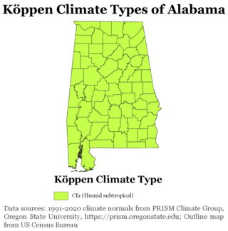
The state of Alabama is classified as humid subtropical (Cfa) under the Köppen climate classification. The state's average annual temperature is 64 °F (18 °C). Temperatures tend to be warmer in the state's southern portion with its proximity to the Gulf of Mexico, while its northern portions, especially in the Appalachian Mountains in the northeast, tend to be slightly cooler. Alabama generally has hot, humid summers and mild winters with copious precipitation throughout the year. The state receives an average of 56 inches (1,400 mm) of rainfall each year and experiences a lengthy growing season of up to 300 days in its southern portion. Hailstorms occur occasionally during the spring and summer here, but they are seldom destructive. Heavy fogs are rare, and they are confined chiefly to the coast. Thunderstorms also occur year-around. They are most common in the summer, but they are most commonly severe during the spring and late autumn. That is when destructive winds and tornadoes occur frequently, especially in the northern and central parts of the state. Central and northern Alabama are squarely within Dixie Alley, the primary area in the U.S. outside the Southern Plains with relatively high tornado risk. Alabama is ranked second in the U.S for the deadliest tornadoes. Hurricanes are quite common in the state, especially in the southern part. Major hurricanes occasionally strike the coast, such as Hurricane Frederic in September 1979 and Hurricane Ivan in September 2004; both storms resulted in significant to devastating damage in the Mobile area.

References

  1. "US Gazetteer files: 2010, 2000, and 1990". United States Census Bureau. February 12, 2011. Retrieved April 23, 2011.
  2. "Archived copy". Archived from the original on June 26, 2013. Retrieved April 18, 2013.{{cite web}}: CS1 maint: archived copy as title (link)
  3. "家庭菜園の方法 ベランダ菜園". www.villagememphis.com.
  4. Memphis Light, Gas, and Water Website – About Our Services Archived July 16, 2010, at the Wayback Machine
  5. L. Yu Lin, Drinking Water from Wells, Not From the River
  6. MLGW – 2005 Water Quality Table Archived December 1, 2007, at the Wayback Machine
  7. "facebook-circle". Arborday.org. Retrieved June 28, 2019.
  8. 1 2 "WMO Climate Normals for MEMPHIS/WSCMO AP TN 1961–1990". National Oceanic and Atmospheric Administration. Retrieved March 10, 2014.
  9. 1 2 3 4 5 6 7 "NowData – NOAA Online Weather Data". National Oceanic and Atmospheric Administration. Retrieved May 25, 2021.
  10. NCDC-NOAA (2015). "ThreadEx [Long-Term Station Extremes for America], Version 10.1, released 2 April 2015". Ithaca, NY, USA: Northeast Regional Climate Center (NRCC, Keith Eggleston) and National Oceanic and Atmospheric Administration (NOAA, Bryant Korzeniewski). Retrieved December 2, 2015.
  11. "Station: Memphis INTL AP, TN". U.S. Climate Normals 2020: U.S. Monthly Climate Normals (1991–2020). National Oceanic & Atmospheric Administration. Retrieved May 25, 2021.
  12. "Historical UV Index Data - Memphis, TN". UV Index Today. Retrieved April 23, 2023.
  13. "Google Maps". Google Maps. Retrieved June 25, 2018.