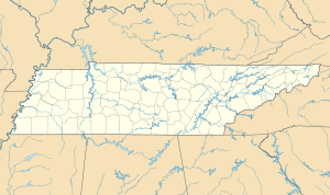
West Tennessee is one of the three Grand Divisions of Tennessee that roughly comprises the western quarter of the state. The region includes 21 counties between the Tennessee and Mississippi rivers, delineated by state law. Its geography consists primarily of flat lands with rich soil and vast floodplain areas of the Mississippi River. Of the three regions, West Tennessee is the most sharply defined geographically, and is the lowest-lying. It is both the least populous and smallest, in land area, of the three Grand Divisions. Its largest city is Memphis, the state's second most populous city.

The Chickasaw Campaign of 1736, also known as the First Chickasaw War, consisted of two pitched battles by the French and allies against Chickasaw fortified villages in present-day Northeast Mississippi. Under the overall direction of the governor of Louisiana, Jean-Baptiste Le Moyne de Bienville, a force from Upper Louisiana attacked Ogoula Tchetoka on March 25, 1736. A second force from Lower Louisiana attacked Ackia on May 26, 1736. Both attacks were bloodily repulsed.

The Wolf River is a 105-mile-long (169 km) alluvial river in western Tennessee and northern Mississippi, whose confluence with the Mississippi River was the site of various Chickasaw, French, Spanish and American communities that eventually became Memphis, Tennessee. It is estimated to be about 12,000 years old, formed by glacier runoff carving into the region's soft alluvial soil. It should not be confused with The Wolf River which flows primarily in Middle Tennessee and southern Kentucky. The Wolf River rises in the Holly Springs National Forest at Baker's Pond in Benton County, Mississippi, and flows northwest into Tennessee, before entering the Mississippi River north of downtown Memphis.
Cotton Gin Port is a ghost town in Monroe County, Mississippi, United States.

Jean-Baptiste Le Moyne de Bienville, also known as Sieur de Bienville, was a French-Canadian colonial administrator in New France. Born in Montreal, he was an early governor of French Louisiana, appointed four separate times during 1701–1743. He was the younger brother of explorer Pierre Le Moyne d'Iberville.

Downtown Memphis, Tennessee is the central business district of Memphis, Tennessee and is located along the Mississippi River between Interstate 40 to the north, Interstate 55 to the south and I-240 to the east, where it abuts Midtown Memphis.
The Wolf River Conservancy (WRC) is a non-profit 501(c)(3) organization whose stated purpose is "conserving and enhancing the Wolf River and its environs as a natural resource for public education and low-impact recreational activities." Headquartered in Memphis, Tennessee. It has approximately 1,500 members from throughout West Tennessee, led by an active Board of Directors and staff and advised by the Wolf River Conservancy Trustees. It is a fully accredited member of The Land Trust Alliance.
Pierre-Joseph Céloron de Blainville — also known as Celeron de Bienville — was a French Canadian Officer of Marine. In 1739 and '40 he led a detachment to Louisiana to fight the Chickasaw in the abortive Chickasaw Campaign of 1739. In 1749 he led the 'Lead Plate Expedition' to advance France's territorial claim on the Ohio Valley.

The Chickasaw Bluff is the high ground rising about 50 to 200 feet (20–60 m) above the Mississippi River flood plain between Fulton in Lauderdale County, Tennessee and Memphis in Shelby County, Tennessee.
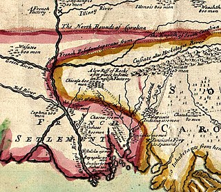
The Chickasaw Wars were fought in the first half of the 18th century between the Chickasaw allied with the British against the French and their allies the Choctaws, Quapaw, and Illinois Confederation. The Province of Louisiana extended from Illinois to New Orleans, and the French fought to secure their communications along the Mississippi River. The Chickasaw, dwelling in northern Mississippi and western Tennessee, lay across the French path. Much to the eventual advantage of the British and the later United States, the Chickasaw successfully held their ground. The wars came to an end only with the French cession of New France to the British in 1763 according to terms of the Treaty of Paris.
The Chickasaw Campaign of 1739, also known as the Second Chickasaw War, was a continuation of the Chickasaw Wars pursued by the French in Louisiana. In 1739 the French prepared extensively but failed to engage the Chickasaw beyond some half-hearted skirmishing, and finally accepted a negotiated peace.

The history of Memphis, Tennessee and its area began many thousands of years ago with succeeding cultures of indigenous peoples. In the first millennium, it was settled by the Mississippian culture. The Chickasaw Indian tribe emerged about the 17th century, or migrated into the area. The earliest European exploration may have encountered remnants of the Mississippian culture by Spanish explorer Hernando de Soto. Later French explorers led by René-Robert Cavelier, Sieur de La Salle likely encountered the Chickasaw. The city of Memphis was not founded until 1819. The city was named after the ancient capital of Egypt on the Nile River in North Africa.

Randolph is a rural unincorporated community in Tipton County, Tennessee, United States, located on the banks of the Mississippi River. Randolph was founded in the 1820s and in 1827, the Randolph post office was established. In the 1830s, the town became an early center of river commerce in West Tennessee. Randolph shipped more cotton annually than Memphis until 1840. In 1834, the first pastor of the Methodist congregation was appointed. The fortunes of the community began to decline in the late 1840s due to failed railroad development, an unfavorable mail route and other factors. The first Confederate States Army fort in Tennessee was built at Randolph early in the Civil War in 1861, a second fortification at Randolph was constructed later that same year. During the Civil War, the town was burned down twice by Union Army forces.
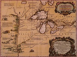
Fort Prudhomme, or Prud'homme, was a simple stockade fortification, constructed in late February 1682 on one of the Chickasaw Bluffs of the Mississippi River in West Tennessee by Cavelier de La Salle's French canoe expedition of the Mississippi River Basin. The fortification was intended to provide shelter during the search for a member of the expedition who got lost at a stop while hunting, it was used by the expedition for only ten days. Fort Prudhomme was the first structure built by the French in Tennessee; its exact location is not known.
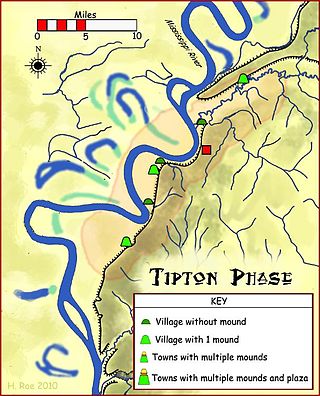
Randolph is an unincorporated rural community in Tipton County, Tennessee, United States, located on the banks of the Mississippi River. The lands of the Mississippi River Basin were inhabited by Paleo-Indians and later Native American tribes of the Mississippian culture for thousands of years. The Tipton phase people and the Chickasaw Indian tribe populated the Mississippi River valley near Randolph during the Mississippian period. In 1541, Spanish explorer Hernando de Soto crossed the Mississippi River at or near Randolph. French explorer Cavelier de La Salle built the first French fortification at or near Randolph on his 1682 canoe expedition of the Mississippi River.

Fort Wright was constructed in 1861 and located on the second Chickasaw Bluff at Randolph, Tipton County, Tennessee. Fort Wright was a Civil War fortification and the first military training facility of the Confederate Army in Tennessee.

Fort Randolph was a Confederate Army fortification built in 1861 during the Civil War. Fort Randolph was located on the second Chickasaw Bluff at Randolph, Tipton County, Tennessee.

Fort Pickering was built in Memphis Tennessee, by the Confederate Army during the American Civil War. It was taken over by the Union Army to provide control of the Mississippi River south of the city.
The following is a timeline of the history of the US state of Tennessee.
The Mississippi River was an important military highway that bordered ten states, roughly equally divided between Union and Confederate loyalties.