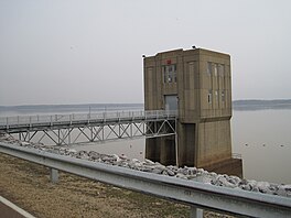
Lake Whitney is a flood control reservoir on the main stem of the Brazos River in Texas. It is located on River Mile Marker 442 and controls drainage for 17,656 square miles (45,730 km2) of Texas and parts of New Mexico. The reservoir encompasses a surface area of more than 23,500 acres and 225 miles (362 km) of shoreline. The area consists of rolling, tallgrass prairies; cedar trees; hardwood timber; and 100 ft (30 m) bluffs and rock points. Lake Whitney is also part of the Texas Lakes Trail Region of North Texas.
Saylorville Lake is a reservoir on the Des Moines River in Iowa, United States. It is located 11 miles (18 km) upstream from the city of Des Moines, and 214 miles (344 km) from the mouth of the Des Moines River at the Mississippi River. It was constructed as part of a flood control system for the Des Moines River as well as to aid in controlling flood crests on the Mississippi, of which the Des Moines is a tributary. The lake and dam is owned and operated by the U.S. Army Corps of Engineers, Rock Island District.
Dierks Lake is a reservoir 56 miles (90 km) down the Saline River, and 5 mi (8 km) from Dierks, Arkansas.

Clinton Lake is a reservoir on the southwestern edge of Lawrence, Kansas. The lake was created by the construction of the Clinton Dam, and the 35 square miles (91 km2) of land and water is maintained by the U.S. Army Corps of Engineers.
Sardis Lake is a 98,520-acre (398.7 km2) reservoir on the Tallahatchie River in Lafayette, Panola, and Marshall counties, Mississippi. Sardis Lake is impounded by Sardis Dam, located nine miles (14 km) southeast of the town of Sardis. It is approximately an hour drive from Memphis, Tennessee. The dam is 15,300 feet (4,700 m) long, has an average height of 97 feet (30 m), and a maximum height of 117 feet (36 m).

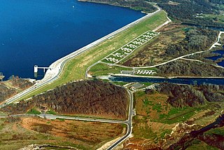
Kentucky Dam is a hydroelectric dam on the Tennessee River on the county line between Livingston and Marshall counties in the U.S. state of Kentucky. The dam is the lowermost of nine dams on the river owned and operated by the Tennessee Valley Authority, which built the dam in the late 1930s and early 1940s to improve navigation on the lower part of the river and reduce flooding on the lower Ohio and Mississippi rivers. It was a major project initiated during the New Deal of President Franklin D. Roosevelt's administration, to invest in infrastructure to benefit the country. The dam impounds the Kentucky Lake of 160,000 acres (65,000 ha), which is the largest of TVA's reservoirs and the largest artificial lake by area in the Eastern United States. It was designated as an National Historic Civil Engineering Landmark by the American Society of Civil Engineers in 1996 and listed on the National Register of Historic Places in 2017.

Grenada Lake is a reservoir on the Yalobusha River in the U.S. state of Mississippi. It is one of four flood control lakes in North Mississippi constructed by the U.S. Army Corps of Engineers. Grenada Lake was constructed to help control flooding along the Yazoo River Basin. The dam is located on the Yalobusha River approximately 3 miles (5 km) northeast of Grenada, Mississippi.
DeQueen Lake is a small reservoir along the Rolling Fork River in Sevier County, Arkansas. It is 4 miles (6 km) from DeQueen, Arkansas.

Isabella Dam is an embankment dam located in the Kern River Valley, about halfway down the Kern River course, between the towns of Kernville and Lake Isabella in Kern County, California.

Lake Altus-Lugert, also known as Lake Altus, Lake Lugert, Lake Lugert-Altus, and Lugert Lake, is a reservoir located on the North Fork Red River, about 17 miles (27 km) north of Altus, Oklahoma on the former site of the town of Lugert, Oklahoma. The river is the boundary between Greer County and Kiowa County, Oklahoma. The lake is used for fishing, boating, swimming, and irrigation. This is also the principal water supply for Altus.

Carlyle Lake is a 25,000-acre (101.2 km2) reservoir largely located in Clinton County, Illinois, United States, with smaller portions of the lake within Bond and Fayette counties. It is the largest man-made lake in Illinois, and the largest lake wholly contained within the state.

Longview Lake is a 930-acre (3.8 km2) freshwater reservoir in parts of Kansas City, Lee's Summit, and Grandview, all in Jackson County, Missouri. The reservoir is part of U.S. Army Corps of Engineers Little Blue River Project for flood control, recreation, and fish and wildlife conservation. The lake is located in the 4,852-acre (20 km2) Longview Lake Park, which is managed by Jackson County Parks and Recreation.

Lavon Lake is a freshwater reservoir located in southeast Collin County, Texas, on the East Fork of the Trinity River near Wylie, off State Highway 78. It is commonly called Lake Lavon for commercial and recreational purposes, but Lavon Lake is its official name according to the U.S. Army Corps of Engineers. It was originally called Lavon Reservoir.
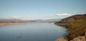
Theodore Roosevelt Lake is a large reservoir formed by Theodore Roosevelt Dam on the Salt River in Arizona as part of the Salt River Project (SRP). Located roughly 80 miles (130 km) northeast of Phoenix in the Salt River Valley, Theodore Roosevelt is the largest lake or reservoir located entirely within the state of Arizona. The reservoir and the masonry dam that created it, Roosevelt Dam, were both named after U.S. President Theodore Roosevelt who dedicated the dam himself in March 1911. Roosevelt Lake is a popular recreation destination within the Tonto National Forest; the facilities located at this lake are managed by that authority.
Grapevine Lake is a reservoir located in the North Texas region, about 20 mi (32 km) northwest of Dallas and northeast of Fort Worth. It was impounded in 1952 by the US Army Corps of Engineers when they dammed Denton Creek, a tributary of Trinity River.

The Harlan County Reservoir includes a dam and a reservoir of 13,250 acres (54 km2) located in Harlan County in south-central Nebraska. Its southernmost part extends into northern Phillips County, Kansas. The reservoir is formed by a dam constructed by the U.S. Army Corps of Engineers on the Republican River, which starts in Colorado and ends in Kansas.

John Redmond Reservoir is a reservoir on the Neosho River in eastern Kansas. Built and managed by the U.S. Army Corps of Engineers, it is used for flood control, recreation, water supply, and wildlife management. It borders the Flint Hills National Wildlife Refuge to the northwest.
Birch Lake is a lake 1.5 miles (2.4 km) south of Barnsdall, Oklahoma, Oklahoma, 20 miles (32 km) southwest of Bartlesville and 30 miles (48 km) northwest of Tulsa. The drainage area for Birch Lake is 66 square miles (170 km2). Its area covers 1,137 acres (4.60 km2). The total capacity is: 52,800 acre-feet (65,100,000 m3), subdivided into: Conservation 15,800 acre-feet (19,500,000 m3), Flood control 39,000 acre-feet (48,000,000 m3), and Inactive storage 15,840 acre-feet (19,540,000 m3).

Kanopolis Lake is a reservoir in Ellsworth County in the Smoky Hills of central Kansas, about 31 miles southwest of Salina and a few miles southeast of the town of Kanopolis. The lake is formed by Kanopolis Dam. Completed in 1948 as a flood control and water conservation project of the United States Army Corps of Engineers, the dam impounds the Smoky Hill River.

Salamonie Dam is a dam in Wabash County, Indiana.