Nutbush, Memphis

Last updated
National Street in Nutbush, Memphis (2008) National nutbush.jpg
National Street in Nutbush, Memphis (2008)

Nutbush is a long-standing neighborhood in northeastern Memphis, Tennessee, United States.

Contents

The area has since expanded, yet it remains relatively small with modestly sized houses.[ citation needed ]

Geography

Nutbush is bordered by I-40 to the north; Wells Station to the east; Macon Avenue to the south, and Homer Street to the west. It is adjacent to the city's Kingsbury neighborhood. [1]

National Cemetery

National Cemetery in Nutbush, Memphis (2004) Memphis national cemetery.jpg
National Cemetery in Nutbush, Memphis (2004)

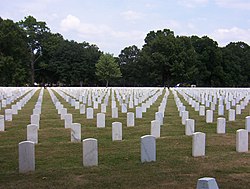
The Memphis National Cemetery is located in Nutbush, Memphis. On 44.2 acres (0.18 km2), the cemetery had 42,184 interments at the end of 2007. [2]

Several battlefield cemeteries from the American Civil War era were transferred to Memphis and many of the dead from the steamboat Sultana explosion on April 26, 1865 were buried in Memphis National Cemetery.

See also

Related Research Articles

<span class="mw-page-title-main">Haywood County, Tennessee</span> County in Tennessee, United States

Haywood County is a county located in the U.S. state of Tennessee, in the region known as West Tennessee. As of the 2020 census, the population was 17,864. Its county seat and largest city is Brownsville. It is one of only two remaining counties in Tennessee, along with Shelby County, with a majority African-American population.

<span class="mw-page-title-main">Brownsville, Tennessee</span> City in Tennessee, United States

Brownsville is a city in and the county seat of Haywood County, Tennessee, United States. Its population as of the 2020 census was 9,788. The city is named after General Jacob Jennings Brown, an American officer of the War of 1812.

<span class="mw-page-title-main">Orange Mound, Memphis</span>

Orange Mound, a neighborhood in southeast Memphis, Tennessee, was the first neighborhood in America to be built by and for African Americans.

<span class="mw-page-title-main">Cooper-Young, Memphis</span> Neighborhood in Memphis, Tennessee, US

Cooper-Young is an eclectic neighborhood and historic district in the Midtown section of Memphis, Tennessee, named for the intersection of Cooper Street and Young Avenue. The entrance to the neighborhood is marked by the Cooper-Young Trestle, a 150-foot (46 m) long steel sculpture which depicts homes and businesses found in the neighborhood. Created by metal artist Jill Turman, the sculpture was dedicated in 2000, and has become a source of community pride and identity. In 2012, Cooper-Young was listed on the American Planning Association's 10 Great Neighborhoods in the U.S list.

<span class="mw-page-title-main">Chickasaw Gardens</span>

Chickasaw Gardens is an established upscale neighborhood in midtown Memphis, Tennessee.

<span class="mw-page-title-main">High Point Terrace, Memphis</span> United States historic place

High Point Terrace is a neighborhood located in the heart of the city of Memphis, Tennessee. The High Point Terrace Historic District is listed on the National Register of Historic Places.

<span class="mw-page-title-main">Nutbush, Tennessee</span> Unincorporated community in Tennessee, United States

Nutbush is a rural unincorporated community in Haywood County, Tennessee, United States, in the western part of the state, approximately 50 miles northeast of Memphis. It was established in the early 19th century by European-American settlers who bought enslaved African Americans to develop the area's cotton plantations. The houses and churches that were built during this time still stand.

South Memphis, one of the oldest portions of Memphis, Tennessee, is a community stretching from Midtown and Downtown to the Mississippi state line. In its early days, it was primarily an agrarian community. South Memphis has many well-known neighborhoods including Whitehaven, Lauderdale Sub, Longview, Riverside, Lakeview Gardens, Prospect Park, Dukestown, Gaslight Square, Wilbert Heights, Mallory Heights, Dixie Heights, Barton Heights, Elliston Heights, Handy Holiday, Chickasaw Village, Pine Hill, Indian Hills, Bunker Hill, Westwood, Boxtown, West Junction, Walker Homes, Coro Lake, Nehemiah, and French Fort. Many of these neighborhoods are considered home to many famous hip hop/R&B singers and rappers. Many locations in South Memphis are also considered a hotbed for crime and violence due to the high amount of gang influence and the overall poverty level of the area. But South Memphis is known for its plentiful houses of worship including Mt. Vernon Baptist Church Westwood, St. Andrew AME Church, Washington Chapel CME Church, East Trigg Baptist Church, White's Chapel AME Church, Union Valley Baptist Church, Enon Springs Baptist Church, Warner Temple AME Zion Church, Unity Baptist Church, Ford's Chapel AME Zion Church, St. Augustine Catholic Church, and Monumental Baptist Church, just naming a few.

<span class="mw-page-title-main">Memphis National Cemetery</span> United States National Cemetery

Memphis National Cemetery is a United States National Cemetery located in the Nutbush neighborhood in northeast Memphis, Tennessee. Administered by the United States Department of Veterans Affairs, it encompasses 44.2 acres (17.9 ha), and as of the end of 2007, had 42,184 interments.

East Memphis is a region of Memphis, Tennessee with several defined and informal subdivisions and neighborhoods such as Colonial Acres, White Station-Yates, Sherwood Forest, Normal Station, High Point Terrace, Belle Meade, Normandy Meadows, St. Nick, Pleasant Acres, Balmoral, and Ridgeway. The general boundaries are informal:

<span class="mw-page-title-main">Trinity United Methodist Church (Nutbush, Tennessee)</span> Church in the United States

Trinity United Methodist Church in Nutbush, Haywood County, Tennessee was founded in 1822. Planters allowed their slaves to attend church with them.

The 8th congressional district of Tennessee is a congressional district in West Tennessee. It has been represented by Republican David Kustoff since January 2017. The district appears rural on a map, but the bulk of its vote is cast in the suburban and exurban areas around Memphis, such as Germantown, Bartlett, and Collierville, as well as Fayette and Tipton counties. This area boasts some of the highest median incomes in the state.

<span class="mw-page-title-main">North Memphis, Memphis, Tennessee</span> Place in Tennessee, United States

North Memphis is one of the five defined districts of Memphis, Tennessee. It includes smaller neighborhoods such as Klondike, New Chicago, Douglass, Hyde Park, Hollywood, Nutbush, Binghampton, Smokey City, Scutterfeld, Frayser, and Raleigh.

Wolfchase is a neighborhood located adjacent to the Bartlett city limits in northeastern Memphis, Tennessee, United States, and is a part of the Memphis metropolitan area. Its name is derived from its proximity to the Wolf River.

<span class="mw-page-title-main">Geography of Memphis, Tennessee</span>

The City of Memphis is located on the eastern bank of the Mississippi River in the southwest corner of the U.S. state of Tennessee. It is the regional hub for a tri-state area of Arkansas, Mississippi and Tennessee.

Capleville is a community in the southeast section of Memphis, Tennessee, United States, and is north of the Mississippi border. It is located 0.5 mi. east of the Memphis International Airport, starting 1 mi. west of the intersection of State Routes 176 and 175, and heading east along State Route 175 crossing U.S. Route 78. The area has been incorporated into the City of Memphis and since has become a large industrial center due to its proximity to the airport and Lamar Avenue which becomes a divided freeway after State Route 175.

<span class="mw-page-title-main">Randolph, Tennessee</span> Unincorporated community in Tennessee, United States

Randolph is a rural unincorporated community in Tipton County, Tennessee, United States, located on the banks of the Mississippi River. Randolph was founded in the 1820s and in 1827, the Randolph post office was established. In the 1830s, the town became an early center of river commerce in West Tennessee. Randolph shipped more cotton annually than Memphis until 1840. In 1834, the first pastor of the Methodist congregation was appointed. The fortunes of the community began to decline in the late 1840s due to failed railroad development, an unfavorable mail route and other factors. The first Confederate States Army fort in Tennessee was built at Randolph early in the Civil War in 1861, a second fortification at Randolph was constructed later that same year. During the Civil War, the town was burned down twice by Union Army forces.

<span class="mw-page-title-main">History of Randolph, Tennessee</span> Aspect of history

Randolph is an unincorporated rural community in Tipton County, Tennessee, United States, located on the banks of the Mississippi River. The lands of the Mississippi River Basin were inhabited by Paleo-Indians and later Native American tribes of the Mississippian culture for thousands of years. The Tipton phase people and the Chickasaw Indian tribe populated the Mississippi River valley near Randolph during the Mississippian period. In 1541, Spanish explorer Hernando de Soto crossed the Mississippi River at or near Randolph. French explorer Cavelier de La Salle built the first French fortification at or near Randolph on his 1682 canoe expedition of the Mississippi River.

<span class="mw-page-title-main">Binghampton, Memphis</span> Human settlement in Memphis, Tennessee, U.S.

Binghampton is a neighborhood on an edge of Midtown in Memphis, Tennessee. It is named after W. H. Bingham, an Irish immigrant, hotelier, planter, magistrate, politician, and entrepreneur who founded a town to the east and slightly north of the Memphis city limits in 1893.

Highland Heights is a neighborhood in Memphis, Tennessee which grew up around the intersection of National Street and Summer Avenue. At its beginning, it was in the county as a rural community, east of the Memphis city limits.

References

  1. https://maps.google.com/maps?q=nutbush,+memphis&ie=UTF8&hl=en&mrt=kmlkmz Google maps - Memphis Neighborhoods
  2. "Memphis National Cemetery". Department of Veterans Affairs. Retrieved 2008-09-21.

35°10′15″N89°56′38″W / 35.1707°N 89.9439°W / 35.1707; -89.9439