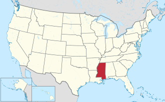
Tunica County | |
---|---|
Coordinates: 34°40′N90°23′W / 34.66°N 90.38°W | |
Country | United States |
State | Mississippi |
Founded | 1836 |
Named for | Tunica-Biloxi tribe |
Seat | Tunica |
Largest town | Tunica Resorts |
Area | |
• Total | 481 sq mi (1,250 km2) |
• Land | 455 sq mi (1,180 km2) |
• Water | 26 sq mi (70 km2) 5.4% |
Population (2020) | |
• Total | 9,782 |
• Density | 20/sq mi (7.9/km2) |
Time zone | UTC−6 (Central) |
• Summer (DST) | UTC−5 (CDT) |
Congressional district | 2nd |
Website | www |
Tunica County is a county located in the U.S. state of Mississippi. As of the 2020 census, the population was 9,782. [1] Its county seat is Tunica. [2] The county is named for the Tunica Native Americans. Most migrated to central Louisiana during the colonial period.
Tunica County is part of the Memphis, TN-MS-AR Metropolitan Statistical Area. It is located in the Mississippi Delta region.
Since the late 20th century, it is known for Tunica Resorts (formerly Robinsonville), an unincorporated community that is the site of six casino resorts. It is one of the top six destinations in the country in terms of gambling revenues. [3]
According to the U.S. Census Bureau, the county has a total area of 481 square miles (1,250 km2), of which 455 square miles (1,180 km2) is land and 26 square miles (67 km2) (5.4%) is water. [4]
Census | Pop. | Note | %± |
---|---|---|---|
1840 | 821 | — | |
1850 | 1,314 | 60.0% | |
1860 | 4,366 | 232.3% | |
1870 | 5,358 | 22.7% | |
1880 | 8,461 | 57.9% | |
1890 | 12,158 | 43.7% | |
1900 | 16,479 | 35.5% | |
1910 | 18,646 | 13.2% | |
1920 | 20,386 | 9.3% | |
1930 | 21,233 | 4.2% | |
1940 | 22,610 | 6.5% | |
1950 | 21,664 | −4.2% | |
1960 | 16,826 | −22.3% | |
1970 | 11,854 | −29.5% | |
1980 | 9,652 | −18.6% | |
1990 | 8,164 | −15.4% | |
2000 | 9,227 | 13.0% | |
2010 | 10,778 | 16.8% | |
2020 | 9,782 | −9.2% | |
2023 (est.) | 9,234 | [5] | −5.6% |
U.S. Decennial Census [6] 1790-1960 [7] 1900-1990 [8] 1990-2000 [9] 2010-2013 [10] |
Race | Num. | Perc. |
---|---|---|
Black or African American | 7,316 | 76.35% |
White | 1,853 | 19.34% |
Native American | 13 | 0.14% |
Asian | 27 | 0.28% |
Other/Mixed | 182 | 1.9% |
Hispanic or Latino | 191 | 1.99% |
As of the 2020 United States Census, there were 9,782 people, 3,930 households, and 2,347 families residing in the county.
As of the 2010 United States Census, there were 10,778 people living in the county. 73.5% were Black or African American, 23.7% White, 0.6% Asian, 0.1% Native American, 0.1% Pacific Islander, 1.2% of some other race and 0.9% of two or more races. 2.3% were Hispanic or Latino (of any race).
As of the census [12] of 2000, there were 9,227 people, 3,258 households, and 2,192 families living in the county. The population density was 20 people per square mile (7.7 people/km2). There were 3,705 housing units at an average density of 8 units per square mile (3.1 units/km2). The racial makeup of the county was 70.15% Black or African American, 27.54% White, 0.11% Native American, 0.42% Asian, 0.07% Pacific Islander, 0.96% from other races, and 0.75% from two or more races. 2.53% of the population were Hispanic or Latino of any race.
There were 3,258 households, out of which 33.30% had children under the age of 18 living with them, 33.90% were married couples living together, 26.90% had a female householder with no husband present, and 32.70% were non-families. 26.90% of all households were made up of individuals, and 9.90% had someone living alone who was 65 years of age or older. The average household size was 2.80 and the average family size was 3.44.
In the county, the population was spread out, with 31.50% under the age of 18, 10.90% from 18 to 24, 27.40% from 25 to 44, 20.20% from 45 to 64, and 10.10% who were 65 years of age or older. The median age was 31 years. For every 100 females there were 91.10 males. For every 100 females age 18 and over, there were 85.90 males.
The median income for a household in the county was $23,270, and the median income for a family was $25,443. Males had a median income of $25,244 versus $18,104 for females. The per capita income for the county was $11,978. About 28.10% of families and 33.10% of the population were below the poverty line, including 43.40% of those under age 18 and 32.50% of those age 65 or over.
Year | Republican | Democratic | Third party | |||
---|---|---|---|---|---|---|
No. | % | No. | % | No. | % | |
2020 | 926 | 25.97% | 2,580 | 72.37% | 59 | 1.65% |
2016 | 853 | 23.91% | 2,667 | 74.77% | 47 | 1.32% |
2012 | 883 | 20.15% | 3,475 | 79.30% | 24 | 0.55% |
2008 | 1,017 | 23.48% | 3,279 | 75.69% | 36 | 0.83% |
2004 | 950 | 30.36% | 2,140 | 68.39% | 39 | 1.25% |
2000 | 792 | 33.47% | 1,539 | 65.05% | 35 | 1.48% |
1996 | 557 | 29.53% | 1,263 | 66.97% | 66 | 3.50% |
1992 | 693 | 30.90% | 1,451 | 64.69% | 99 | 4.41% |
1988 | 896 | 36.87% | 1,510 | 62.14% | 24 | 0.99% |
1984 | 1,109 | 39.55% | 1,621 | 57.81% | 74 | 2.64% |
1980 | 954 | 29.77% | 2,198 | 68.58% | 53 | 1.65% |
1976 | 951 | 34.51% | 1,695 | 61.50% | 110 | 3.99% |
1972 | 1,446 | 62.19% | 858 | 36.90% | 21 | 0.90% |
1968 | 413 | 17.73% | 1,133 | 48.65% | 783 | 33.62% |
1964 | 945 | 90.52% | 99 | 9.48% | 0 | 0.00% |
1960 | 334 | 37.24% | 323 | 36.01% | 240 | 26.76% |
1956 | 200 | 23.92% | 470 | 56.22% | 166 | 19.86% |
1952 | 383 | 41.95% | 530 | 58.05% | 0 | 0.00% |
1948 | 12 | 1.60% | 23 | 3.07% | 715 | 95.33% |
1944 | 35 | 4.63% | 721 | 95.37% | 0 | 0.00% |
1940 | 13 | 1.61% | 795 | 98.39% | 0 | 0.00% |
1936 | 5 | 0.71% | 701 | 99.29% | 0 | 0.00% |
1932 | 8 | 1.38% | 573 | 98.62% | 0 | 0.00% |
1928 | 26 | 3.82% | 654 | 96.18% | 0 | 0.00% |
1924 | 13 | 2.56% | 495 | 97.44% | 0 | 0.00% |
1920 | 2 | 0.77% | 256 | 98.84% | 1 | 0.39% |
1916 | 0 | 0.00% | 173 | 100.00% | 0 | 0.00% |
1912 | 1 | 0.52% | 188 | 97.41% | 4 | 2.07% |
National Register of Historic Places listings in Tunica County, Mississippi
Warren County is a county located in the U.S. state of Mississippi. Its western border is formed by the Mississippi River. As of the 2020 census, the population was 44,722. Its county seat is Vicksburg. Established by legislative act of December 22, 1809, Warren County is named for American Revolutionary War officer Joseph Warren.
Walthall County is a county located in the U.S. state of Mississippi. As of the 2020 census, the population was 13,884. Its county seat is Tylertown. The county is named after Civil War Confederate general and Mississippi Senator Edward C. Walthall.
Union County is a county located in the U.S. state of Mississippi. It was formed in 1870 from Tippah and Pontotoc counties, and in 1874 a portion of Lee County was added. As of the 2020 census, the population was 27,777. Its county seat is New Albany. According to most sources, the county received its name by being a union of pieces of several large counties, like other Union counties in other states. However, other sources say that the name was meant to mark the re-union of Mississippi and the other Confederate states after the Civil War.
Tate County is a county located in the northwestern portion of the U.S. state of Mississippi. As of the 2020 census, the population was 28,064. Its county seat is Senatobia. Organized in 1873 during the Reconstruction era, from portions of DeSoto, Marshall, and Tunica counties, the county is named for Thomas Simpson Tate, one of the first prominent American settlers of the area.
Quitman County is a county located in the U.S. state of Mississippi. As of the 2020 census, the population was 6,176, making it the third-least populous county in Mississippi. Its county seat is Marks. The county is named after John A. Quitman, Governor of Mississippi from 1835 to 1836 and from 1850 to 1851.
Pontotoc County is a county located in the U.S. state of Mississippi. As of the 2020 census, the population was 31,184. Its county seat is Pontotoc. It was created on February 9, 1836, from lands ceded to the United States under the Chickasaw Cession. Pontotoc is a Chickasaw word meaning "land of hanging grapes". The original Natchez Trace and the current-day Natchez Trace Parkway both pass through the southeast corner of Pontotoc County.
Newton County is a county located in the U.S. state of Mississippi. As of the 2020 census, the population was 21,291. Its county seat is Decatur.
Madison County is a county located in the U.S. state of Mississippi. As of the 2020 census, the population was 109,145. The county seat is Canton. The county is named for Founding Father and U.S. President James Madison.
Coahoma County is a county located in the U.S. state of Mississippi. As of the 2020 census, the population was 21,390. Its county seat is Clarksdale.
Calhoun County is a county located in the U.S. state of Mississippi. As of the 2020 census, the population was 13,266. Its county seat is Pittsboro. The county is named after John C. Calhoun, the U.S. Vice President and U.S. Senator from South Carolina.
Attala County is a county located in the U.S. state of Mississippi. As of the 2020 census, the population was 17,889. Its county seat is Kosciusko. Attala County is named for Atala, a fictional Native American heroine from an early-19th-century novel of the same name by François-René de Chateaubriand.
Alcorn County is a county located in the northeastern portion of the U.S. state of Mississippi. As of the 2020 census, the population was 34,740. Its county seat is Corinth. The county is named in honor of Governor James L. Alcorn.
Crittenden County is a county located in the U.S. state of Arkansas. As of the 2020 census, the population was 48,163. The county seat is Marion, and the largest city is West Memphis.
Hardy is the 2nd oldest city in Sharp and Fulton counties in the U.S. state of Arkansas. The population was 765 in 2020.
Schlater is a town in Leflore County, Mississippi, United States. The population was 310 at the 2010 census, down from 388 at the 2000 census. It is part of the Greenwood, Mississippi micropolitan area.
Algoma is a town in Pontotoc County, Mississippi. The population was 705 at the 2020 census, up from 590 at the 2010 census.
Richland is a city in Rankin County, Mississippi, United States. The population was 7,137 at the 2020 census. A suburb of Jackson, Richland is part of the Jackson Metropolitan Statistical Area, and is located southeast of the state capital.
North Tunica is a census-designated place (CDP) in Tunica County, Mississippi. The population was 1,450 at the 2000 census.
Tunica is a town in and the county seat of Tunica County, Mississippi, United States, near the Mississippi River. Until the early 1990s when casino gambling was introduced in the area, Tunica had been one of the most impoverished places in the United States. Despite this economic improvement, Tunica's population continues to decline from its peak in 1970.
Tunica Resorts, formerly known as Robinsonville until 2005, is a census-designated place (CDP) in northern Tunica County, Mississippi, United States, north of the county seat of Tunica. The community is situated mostly between the Mississippi River and U.S. Route 61, along the border with Arkansas. The population as of the 2020 census was 2,132.