The Illinois River is a principal tributary of the Mississippi River and is approximately 273 miles (439 km) long. Located in the U.S. state of Illinois, the river drains a large section of central Illinois, with a drainage basin of 28,756.6 square miles (74,479 km2). The drainage basin extends into Wisconsin, Indiana, and a very small area of southwestern Michigan.

Tunica County is a county located in the U.S. state of Mississippi. As of the 2010 census, the population was 10,778. Its county seat is Tunica. The county is named for the Tunica Native Americans. Most migrated to central Louisiana during the colonial period.

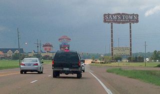
Tunica is a town in and the county seat of Tunica County, Mississippi, United States, near the Mississippi River. Until the early 1990s when casino gambling was introduced in the area, Tunica had been one of the most impoverished places in the United States. Despite this economic improvement, Tunica's population continues to decline from its peak in 1970.

Austin is an unincorporated community in Tunica County, Mississippi, United States.
Mhoon Landing is an unincorporated community located on the Mississippi River in Tunica County, Mississippi, United States. It is approximately 6 miles (9.7 km) northwest of North Tunica and approximately 12 miles (19 km) southwest of Tunica Resorts.
Christmas is an unincorporated community in Bolivar County, Mississippi, United States. Christmas is located along Mississippi Highway 1, 0.7 miles (1.1 km) south of Beulah.

Lake Beulah is an oxbow lake located in Bolivar County, Mississippi and Desha County, Arkansas, United States. The Arkansas-Mississippi border follows the center of the narrow, curving lake.
Commerce is a ghost town in Tunica County, Mississippi, United States. Commerce Landing was the town's port.
Bolivar is an unincorporated community in Bolivar County, Mississippi, United States.
Concordia is a ghost town in Bolivar County, Mississippi, United States, located on the eastern edge of the Mississippi Levee, approximately 2.5 mi (4.0 km) west of Mississippi Highway 1.
Tunica Lake is an oxbow lake located in Lee County, Arkansas and Tunica County, Mississippi. The Arkansas-Mississippi border follows the center of the narrow, curving lake.
Lake Whittington is an oxbow lake located in Bolivar County, Mississippi, and Desha County, Arkansas, United States. The Arkansas-Mississippi border follows the center of the narrow, curving lake.
Port Royal is a ghost town in Coahoma County, Mississippi, United States.
Trotter Landing is a ghost town in Tunica County, Mississippi, United States.
Chotard is an unincorporated community in Issaquena County, Mississippi, United States.
Briers is a ghost town located in Adams County, Mississippi, United States. Briar Landing was its port, located directly on the Mississippi River.
Artonish is a ghost town located in Wilkinson County, Mississippi, United States. South of the town was Artonish Landing, located on a stretch of the Mississippi River known as the "Homochitto Cutoff".
Sunflower Landing is an unincorporated community in Coahoma County, Mississippi, United States.
Anderson Landing is an unincorporated community in Coahoma County, Mississippi, United States.
Riverton is a ghost town in Bolivar County, Mississippi, United States.