Clarke County | |
---|---|
Coordinates: 32°02′N88°41′W / 32.04°N 88.69°W | |
Country | United States |
State | Mississippi |
Founded | December 23, 1833 [1] |
Seat | Quitman |
Largest city | Quitman |
Area | |
• Total | 694 sq mi (1,800 km2) |
• Land | 692 sq mi (1,790 km2) |
• Water | 2.0 sq mi (5 km2) 0.3% |
Population (2020) | |
• Total | 15,615 |
• Density | 23/sq mi (8.7/km2) |
Time zone | UTC−6 (Central) |
• Summer (DST) | UTC−5 (CDT) |
Congressional district | 3rd |
Website | "Visit Clarke County". |
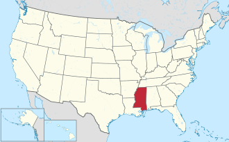
Clarke County is a county located in the U.S. state of Mississippi. As of the 2020 census, the population was 15,615. [2] Its county seat is Quitman. [3] Clarke County is named for Joshua G. Clarke, [4] the first Mississippi state chancellor and judge.
The county is part of the Meridian, MS Micropolitan Statistical Area.
Before Europeans first arrived, the Choctaw Indians inhabited the land that would later be known as the Clarke County, Mississippi. Clarke County is only a portion of what was known as Okla Hannali or Six Town District of the Choctaws. Okla Hannali or Six Towns District existed at the time of the Dancing Rabbit Treaty in 1830. [5]
David Gage, who came to the area in about 1820, was a Presbyterian minister. Traveling with him was Moses Jewel and Miss Skinner, who were both teachers. He settled at a place called Eewennans in the Choctaw Nation. David Gage, Moses Jewel, and Miss Skinner came to the territory for the purpose of educating the Indians some domestic habits. [6]
At the beginning of 1832, settlers began to appear in what was known as the “New Purchase”. One of the first families to arrive was Jehu and Sarah Pagaus Evans, who arrived in February 1832, and settled east of Buckatunna Swamp. By the fall of 1832, the “New Purchase” began to fill up quickly with arrivals. Among the early settlers were George Evans, Richard Wagster, Henry Hailes, Alex Hailes, Michael McCarty, James Bankston, Calvin M. Ludlow, John Williford, William Williford, James Risher, J. A. Fontain, John Gunn, Robert Fleming, John Fleming, Hiram Fleming, Norman Martin, Stephen Grice, Thomas F. Hicks, Alex McLendon, Roland B. Crosby, Cameron Grayson, Jesse C. Mott, David Neely, David B. Thompson, Dabney Edwards, Jacob Slack, John Johnston, Alex Trotter, Richard N. Hough, Robert McLaughlin, L. D. Phillips, Samuel Lee, Jesse Sumrall, Jeremiah Crane, Howell Sumrall, William Goleman, Thomas Goleman, Samuel K. Lewis and Thomas Watts. [7]
The county was founded in 1833. Quitman, named for General John A. Quitman. [4] [7]
After the organization of Clarke County, the first school was built close to the old Tennessee Trace. Mr. Hennessy was the teacher and he came from Kinsale, Ireland. Religious services were held in the pioneer families’ home and on days of good weather, outside. The first actual church built was Cedar Creek Church, a Methodist church, and Elim Baptist Church followed in the 1840s.
In the Spring of 1834, Joel Nail, a quadroon Indian, began moving the Choctaw Indians to Muskalresha, an old town in Neshoba County, Mississippi. These journeys continued through 1838 for all that would go. Some of the Choctaw Indians returned to their homes in Clarke County after arriving at Muskalresha. [6]
In the 1830s there were no postal routes in Clarke County. However, there was a stagecoach line from Columbus, Mississippi to Winchester, Wayne County, Mississippi. The settlers of Clarke County would have to travel to Winchester, 25 miles away to receive their mail. [6]
Ten black people were lynched in Clarke County, as documented in The Hanging Bridge by Jason Morgan Ward. [8]
According to the U.S. Census Bureau, the county has a total area of 694 square miles (1,800 km2), of which 692 square miles (1,790 km2) is land and 2.0 square miles (5.2 km2) (0.3%) is water. [9] The Chickasawhay River flows north to south through the eastern portion of the county; it eventually meets the Pascagoula River.
Census | Pop. | Note | %± |
---|---|---|---|
1840 | 2,986 | — | |
1850 | 5,477 | 83.4% | |
1860 | 10,771 | 96.7% | |
1870 | 7,505 | −30.3% | |
1880 | 15,021 | 100.1% | |
1890 | 15,826 | 5.4% | |
1900 | 17,741 | 12.1% | |
1910 | 21,630 | 21.9% | |
1920 | 17,927 | −17.1% | |
1930 | 19,679 | 9.8% | |
1940 | 20,596 | 4.7% | |
1950 | 19,362 | −6.0% | |
1960 | 16,493 | −14.8% | |
1970 | 15,049 | −8.8% | |
1980 | 16,945 | 12.6% | |
1990 | 17,313 | 2.2% | |
2000 | 17,955 | 3.7% | |
2010 | 16,732 | −6.8% | |
2020 | 15,615 | −6.7% | |
2023 (est.) | 15,228 | [10] | −2.5% |
U.S. Decennial Census [11] 1790-1960 [12] 1900-1990 [13] 1990-2000 [14] 2010-2013 [15] |
Race | Num. | Perc. |
---|---|---|
White | 9,950 | 63.72% |
Black or African American | 5,103 | 32.68% |
Native American | 16 | 0.1% |
Asian | 8 | 0.05% |
Pacific Islander | 6 | 0.04% |
Other/Mixed | 400 | 2.56% |
Hispanic or Latino | 132 | 0.85% |
As of the 2020 United States census, there were 15,615 people, 6,237 households, and 4,397 families residing in the county.
As of 2017 the largest self-identified ancestry groups/ethnic groups in Clarke County, Mississippi were: [17] [18]
Largest ancestries (2017) | Percent |
---|---|
English | 22.37% |
"American" | 10.6% |
Irish | 7.04% |
German | 2.65% |
Dutch | 1.4% |
Scots-Irish | 1.3% |
Scottish | 1.1% |
French (except Basque) | 0.6% |
Year | Republican | Democratic | Third party(ies) | |||
---|---|---|---|---|---|---|
No. | % | No. | % | No. | % | |
2024 | 5,093 | 67.27% | 2,430 | 32.10% | 48 | 0.63% |
2020 | 5,417 | 64.97% | 2,838 | 34.04% | 83 | 1.00% |
2016 | 5,137 | 65.94% | 2,585 | 33.18% | 69 | 0.89% |
2012 | 5,049 | 61.18% | 3,111 | 37.70% | 93 | 1.13% |
2008 | 5,229 | 62.27% | 3,121 | 37.17% | 47 | 0.56% |
2004 | 5,068 | 67.51% | 2,402 | 32.00% | 37 | 0.49% |
2000 | 4,503 | 65.08% | 2,368 | 34.22% | 48 | 0.69% |
1996 | 3,470 | 56.04% | 2,337 | 37.74% | 385 | 6.22% |
1992 | 4,207 | 60.67% | 2,259 | 32.58% | 468 | 6.75% |
1988 | 4,522 | 63.71% | 2,576 | 36.29% | 0 | 0.00% |
1984 | 4,551 | 66.61% | 2,262 | 33.11% | 19 | 0.28% |
1980 | 3,303 | 49.14% | 3,303 | 49.14% | 115 | 1.71% |
1976 | 2,935 | 48.96% | 2,816 | 46.97% | 244 | 4.07% |
1972 | 4,561 | 81.56% | 954 | 17.06% | 77 | 1.38% |
1968 | 298 | 5.53% | 878 | 16.29% | 4,214 | 78.18% |
1964 | 3,591 | 93.42% | 253 | 6.58% | 0 | 0.00% |
1960 | 586 | 17.71% | 1,244 | 37.61% | 1,478 | 44.68% |
1956 | 500 | 20.77% | 1,763 | 73.24% | 144 | 5.98% |
1952 | 754 | 27.38% | 2,000 | 72.62% | 0 | 0.00% |
1948 | 17 | 0.88% | 144 | 7.47% | 1,767 | 91.65% |
1944 | 95 | 5.31% | 1,694 | 94.69% | 0 | 0.00% |
1940 | 42 | 2.40% | 1,711 | 97.60% | 0 | 0.00% |
1936 | 31 | 1.46% | 2,089 | 98.40% | 3 | 0.14% |
1932 | 53 | 3.44% | 1,482 | 96.11% | 7 | 0.45% |
1928 | 563 | 33.23% | 1,131 | 66.77% | 0 | 0.00% |
1924 | 87 | 6.24% | 1,306 | 93.62% | 2 | 0.14% |
1920 | 47 | 5.35% | 807 | 91.91% | 24 | 2.73% |
1916 | 49 | 4.19% | 1,092 | 93.33% | 29 | 2.48% |
1912 | 17 | 2.29% | 638 | 85.87% | 88 | 11.84% |
There are two school districts in the county: Quitman School District and Enterprise School District. [20]
The county is in the zone for Jones College. [21]
The Choctaw are a Native American people originally based in the Southeastern Woodlands, in what is now Mississippi and Alabama. The Choctaw language is a Western Muskogean language. Today, Choctaw people are enrolled in four federally recognized tribes: the Choctaw Nation of Oklahoma, Mississippi Band of Choctaw Indians, Jena Band of Choctaw Indians in Louisiana, and the Yowani Choctaws enrolled under the confederacy of the Caddo Nation.
Montgomery County is a county located in the U.S. state of Mississippi. As of the 2020 census, the population was 9,822. Its county seat is Winona.
Clarke County is a county located in the southwestern part of the U.S. state of Alabama. As of the 2020 census, the population was 23,087. The county seat is Grove Hill. The county's largest city is Jackson. The county was created by the legislature of the Mississippi Territory in 1812. It is named in honor of General John Clarke of Georgia, who was later elected governor of that state.
Mobile County is a county located in the southwestern corner of the U.S. state of Alabama. It is the third-most populous county in the state after Jefferson and Madison counties. As of the 2020 census, its population was 414,809. Its county seat is Mobile, which was founded as a deepwater port on the Mobile River. The only such port in Alabama, it has long been integral to the economy for providing access to inland waterways as well as the Gulf of Mexico.
Washington County is a county located in the southwestern part of the U.S. state of Alabama. As of the 2020 census, the population was 15,388. The county seat is Chatom. The county was named in honor of George Washington, the first President of the United States. In September 2018 The United States Office of Management and Budget (OMB) added Washington County to the Mobile, Alabama Metropolitan Statistical Area but was removed in effective July 2023.
Pontotoc County is a county in the south central part of Oklahoma. As of the 2020 census, the population was 38,065. Its county seat is Ada. The county was created at statehood from part of the Chickasaw Nation in Indian Territory. It was named for a historic Chickasaw tribal area in Mississippi. According to the Encyclopedia of Oklahoma History and Culture, Pontotoc is usually translated "cattail prairie" or "land of hanging grapes."
Webster County is a county located in center of the U.S. state of Mississippi, bordered on the south by the Big Black River. As of the 2020 census, the population was 9,926.
Wayne County is a county located in the U.S. state of Mississippi. As of the 2020 census, the population was 19,779. Its county seat is Waynesboro. The county is named for General Anthony Wayne.
Tallahatchie County is a county in the U.S. state of Mississippi. At the 2020 census, the population was 12,715. Its county seats are Charleston and Sumner.
Quitman County is a county located in the U.S. state of Mississippi. As of the 2020 census, the population was 6,176, making it the third-least populous county in Mississippi. Its county seat is Marks. The county is named after John A. Quitman, Governor of Mississippi from 1835 to 1836 and from 1850 to 1851.
Perry County is a county located in the U.S. state of Mississippi. As of the 2020 census, the population was 11,511. The county seat is New Augusta. The county is named after the War of 1812 naval hero, Oliver Hazard Perry.
Panola County is a county located in the U.S. state of Mississippi. As of the 2020 census, the population was 33,208. Its county seats are Sardis and Batesville. The county is located just east of the Mississippi Delta in the northern part of the state. It is bisected by the Tallahatchie River flowing to the southwest; travel difficulties because of the river resulted in two county seats being established.
Oktibbeha County is a county in the east central portion of the U.S. state of Mississippi. As of the 2020 census the population was 51,788. The county seat is Starkville. The county's name is derived from a Choctaw word meaning "icy creek". The Choctaw had long occupied much of this territory prior to European exploration and United States acquisition.
Neshoba County is a county located in the central part of the U.S. state of Mississippi. As of the 2020 census, the population was 29,087. Its county seat is Philadelphia.
Coahoma County is a county located in the U.S. state of Mississippi. As of the 2020 census, the population was 21,390. Its county seat is Clarksdale.
Choctaw County is a county located in the central part of the U.S. state of Mississippi. As of the 2020 census, the population was 8,246. Its northern border is the Big Black River, which flows southwest into the Mississippi River south of Vicksburg. The county seat is Ackerman.
Stewart County is a county located in the west central portion of the U.S. state of Georgia. As of the 2020 census, the population was 5,314. The county seat is Lumpkin. The county was created on December 23, 1830.
Quitman is a city in and the county seat of Clarke County, Mississippi, United States, along the Chickasawhay River. The population was 2,323 at the 2010 census.
Eagletown is an unincorporated community and census-designated place in McCurtain County, Oklahoma, United States. The population was 528 at the 2010 census. Located on Mountain Fork River, approximately 6 miles (9.7 km) from the Oklahoma-Arkansas border, it was the first permanent Choctaw settlement in the Indian Territory, who called it o̱ssi tamaha ("Eagle"). Eagletown was an important town from 1834 to 1906, and after 1850, served as county seat for the Choctaw Nation's Eagle County. The town name was officially changed to "Eagle Town" in 1850, then changed to the present Eagletown in 1892. When Indian Territory was preparing to unite with Oklahoma Territory to form the new state of Oklahoma in 1906, Eagletown lost its county seat status and became just another unincorporated community in the new McCurtain County.
Apuckshunubbee was one of three principal chiefs of the Choctaw Native American tribe in the early nineteenth century, from before 1800. He led the western or Okla Falaya District of the Choctaw, of which the eastern edge ran roughly southeast from modern Winston County to Lauderdale County, then roughly southwest to Scott County, then roughly south-southeast to the western edge of Perry County. His contemporaries were Pushmataha and Moshulatubbee, who respectively led the southern district Okla Hannali and the north-eastern district Okla Tannap.