Jefferson Davis County | |
---|---|
County | |
Coordinates: 31°34′N89°49′W / 31.56°N 89.82°W | |
Country | United States |
State | Mississippi |
Founded | 1906 |
Named for | Jefferson Davis |
Seat | Prentiss |
Largest town | Prentiss |
Area | |
• Total | 409 sq mi (1,060 km2) |
• Land | 408 sq mi (1,060 km2) |
• Water | 0.7 sq mi (2 km2) 0.2% |
Population (2020) | |
• Total | 11,321 |
• Density | 28/sq mi (11/km2) |
Time zone | UTC−6 (Central) |
• Summer (DST) | UTC−5 (CDT) |
Congressional district | 3rd |
Website | www.jeffersondaviscountyms.com |
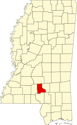
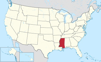
Jefferson Davis County is a county located in the U.S. state of Mississippi. As of the 2020 census, the population was 11,321. [1] Its county seat is Prentiss. [2] The county is named after Mississippi Senator and Confederate President Jefferson Davis. The county was carved out of Covington and Lawrence counties in March 1906. Governor James K. Vardaman signed the bill creating the county on May 9, 1906.
The genesis of the county occurred on March 31, 1906, when a Mississippi state legislative act authorized the new country's boundaries. The residents of western Covington County and eastern Lawrence County had frequently complained of the rivers and streams impeding the route to their respective county seats. Jefferson Davis County was the state's 77th county.
A 1906 special referendum determined that the county seat would be Prentiss, named for either famed Mississippi lawmaker and orator Seargent Smith Prentiss, or wealthy landowner Prentiss Webb Berry. The settlement was originally named Blountville after early settler William Blount.
In 1933, the county was the first in Mississippi to issue a prohibition on alcohol after the repeal of the Eighteenth Amendment to the United States Constitution. Round dancing in the community hall was banned in 1938.
In 1935, notorious bank robber Raymond Hamilton, known to hide out in the county's wilderness, was involved in a hostage situation after robbing Prentiss' Bank of Blountville, but escaped in Memphis. [3]
According to the U.S. Census Bureau, the county has a total area of 409 square miles (1,060 km2), of which 408 square miles (1,060 km2) is land and 0.7 square miles (1.8 km2) (0.2%) is water. [4]
Census | Pop. | Note | %± |
---|---|---|---|
1910 | 12,860 | — | |
1920 | 12,755 | −0.8% | |
1930 | 14,281 | 12.0% | |
1940 | 15,869 | 11.1% | |
1950 | 15,500 | −2.3% | |
1960 | 13,540 | −12.6% | |
1970 | 12,936 | −4.5% | |
1980 | 13,846 | 7.0% | |
1990 | 14,051 | 1.5% | |
2000 | 13,962 | −0.6% | |
2010 | 12,487 | −10.6% | |
2020 | 11,321 | −9.3% | |
2023 (est.) | 10,969 | [5] | −3.1% |
U.S. Decennial Census [6] 1790-1960 [7] 1900-1990 [8] 1990-2000 [9] 2010-2013 [10] |
Race | Num. | Perc. |
---|---|---|
White (non-Hispanic) | 4,330 | 38.25% |
Black or African American (non-Hispanic) | 6,622 | 58.49% |
Native American | 8 | 0.07% |
Asian | 21 | 0.19% |
Other/Mixed | 239 | 2.11% |
Hispanic or Latino | 101 | 0.89% |
As of the 2020 United States census, there were 11,321 people, 4,713 households, and 3,003 families residing in the county.
Typical of a majority-black county in Mississippi, Jefferson Davis leans Democratic and last voted Republican in 1984.
Year | Republican | Democratic | Third party(ies) | |||
---|---|---|---|---|---|---|
No. | % | No. | % | No. | % | |
2024 | 2,302 | 42.80% | 3,041 | 56.55% | 35 | 0.65% |
2020 | 2,534 | 40.79% | 3,599 | 57.93% | 80 | 1.29% |
2016 | 2,466 | 39.54% | 3,720 | 59.64% | 51 | 0.82% |
2012 | 2,507 | 36.52% | 4,267 | 62.16% | 90 | 1.31% |
2008 | 2,871 | 38.96% | 4,454 | 60.43% | 45 | 0.61% |
2004 | 2,668 | 46.28% | 2,959 | 51.33% | 138 | 2.39% |
2000 | 2,437 | 45.83% | 2,835 | 53.32% | 45 | 0.85% |
1996 | 1,890 | 38.84% | 2,663 | 54.73% | 313 | 6.43% |
1992 | 2,228 | 39.55% | 2,991 | 53.10% | 414 | 7.35% |
1988 | 2,745 | 47.92% | 2,948 | 51.47% | 35 | 0.61% |
1984 | 2,884 | 51.81% | 2,644 | 47.50% | 38 | 0.68% |
1980 | 2,280 | 36.85% | 3,831 | 61.92% | 76 | 1.23% |
1976 | 1,868 | 39.76% | 2,747 | 58.47% | 83 | 1.77% |
1972 | 2,830 | 72.83% | 1,005 | 25.86% | 51 | 1.31% |
1968 | 297 | 6.79% | 1,465 | 33.48% | 2,614 | 59.73% |
1964 | 2,351 | 90.91% | 235 | 9.09% | 0 | 0.00% |
1960 | 225 | 13.06% | 510 | 29.60% | 988 | 57.34% |
1956 | 156 | 10.92% | 1,049 | 73.41% | 224 | 15.68% |
1952 | 473 | 22.53% | 1,626 | 77.47% | 0 | 0.00% |
1948 | 51 | 3.30% | 41 | 2.66% | 1,452 | 94.04% |
1944 | 88 | 6.03% | 1,372 | 93.97% | 0 | 0.00% |
1940 | 38 | 2.86% | 1,289 | 96.92% | 3 | 0.23% |
1936 | 67 | 4.81% | 1,325 | 95.05% | 2 | 0.14% |
1932 | 30 | 3.09% | 940 | 96.71% | 2 | 0.21% |
1928 | 163 | 16.00% | 856 | 84.00% | 0 | 0.00% |
1924 | 88 | 10.73% | 732 | 89.27% | 0 | 0.00% |
1920 | 179 | 26.76% | 485 | 72.50% | 5 | 0.75% |
1916 | 45 | 6.59% | 634 | 92.83% | 4 | 0.59% |
1912 | 43 | 6.63% | 542 | 83.51% | 64 | 9.86% |
Jefferson Davis County Courthouse in Prentiss is listed on the National Register of Historic Places.
All residents are zoned to the Jefferson Davis County School District. [13]
The county is in the zone of Pearl River Community College. [14]
Clay County is a county in the U.S. state of Mississippi. As of the 2020 census, the population was 18,636. Its county seat is West Point. Its name is in honor of American statesman Henry Clay, member of the United States Senate from Kentucky and United States Secretary of State in the 19th century. J. Wesley Caradine, an African American, was the first state representative for Clay County after it was established in 1871. The federal government formerly designated Clay County as the West Point Micropolitan Statistical Area, but the county lost that status in 2013. It is part of the Golden Triangle region of the state.
Wayne County is a county located in the U.S. state of Mississippi. As of the 2020 census, the population was 19,779. Its county seat is Waynesboro. The county is named for General Anthony Wayne.
Union County is a county located in the U.S. state of Mississippi. It was formed in 1870 from Tippah and Pontotoc counties, and in 1874 a portion of Lee County was added. As of the 2020 census, the population was 27,777. Its county seat is New Albany. According to most sources, the county received its name by being a union of pieces of several large counties, like other Union counties in other states. However, other sources say that the name was meant to mark the re-union of Mississippi and the other Confederate states after the Civil War.
Tishomingo County is a county located in the northeastern corner of the U.S. state of Mississippi. As of the 2020 census, the population was 18,850. Its county seat is Iuka.
Tate County is a county located in the northwestern portion of the U.S. state of Mississippi. As of the 2020 census, the population was 28,064. Its county seat is Senatobia. Organized in 1873 during the Reconstruction era, from portions of DeSoto, Marshall, and Tunica counties, the county is named for Thomas Simpson Tate, one of the first prominent American settlers of the area.
Simpson County is a county located in the U.S. state of Mississippi. Its western border is formed by the Pearl River, an important transportation route in the 19th century. As of the 2020 census, the population was 25,949. The county seat is Mendenhall. The county is named for Josiah Simpson (1787-1817), a territorial judge who also served as a delegate to Mississippi's Constitutional Convention.
Prentiss County is a county located in the U.S. state of Mississippi. As of the 2020 census, the population was 25,008. Its county seat is Booneville. The county is named for Seargent Smith Prentiss, a noted speaker and US Congressman from Natchez.
Pike County is a county located on the southwestern border of the U.S. state of Mississippi. As of the 2020 census, the population was 40,324. The county seat is Magnolia. Pike County is named for explorer Zebulon Pike. Pike County is part of the McComb, MS Micropolitan Statistical Area.
Perry County is a county located in the U.S. state of Mississippi. As of the 2020 census, the population was 11,511. The county seat is New Augusta. The county is named after the War of 1812 naval hero, Oliver Hazard Perry.
Marion County is a county located in the U.S. state of Mississippi. As of the 2020 census, the population was 24,441. Its county seat is Columbia. Marion County is named for American Revolutionary War guerrilla leader Francis Marion also known as The Swamp Fox.
Lee County is a county in U.S. state of Mississippi. At the 2020 census, the population was 83,343. Its county seat is Tupelo. Lee County is included in the Tupelo Micropolitan Statistical Area.
Lawrence County is a county located in the U.S. state of Mississippi. As of the 2020 census, the population was 12,016. Its county seat is Monticello. The county is named for the naval hero James Lawrence.
Lamar County is a county located in the U.S. state of Mississippi. As of the 2020 census, the population was 64,222. Its county seat is Purvis. Named for Confederate Lucius Quintus Cincinnatus Lamar, the county was carved out of Marion County to the west in 1904.
Jefferson County is a county located in the U.S. state of Mississippi; its western border is formed by the Mississippi River. As of the 2020 census, the population was 7,260, making it the fourth-least populous county in Mississippi. Its first county seat was located at Old Greenville until 1825, which no longer exists, before moving to Fayette. The county is named for U.S. President Thomas Jefferson. One of the first of two counties organized in the Mississippi Territory in 1798 along with Adams County, it was first named Pickering County and included what would become Claiborne County. Originally developed as cotton plantations in the antebellum era, the rural county has struggled with a declining economy and reduced population since the mechanization of agriculture and urbanization of other areas. In 2020, its population of 7,260 was roughly one-third of the population peak in 1900. Within the United States, in 2009 rural Jefferson County had the highest percentage of African-Americans of any county. It was the fourth-poorest county in the nation.
Jasper County is located in the U.S. state of Mississippi. At the 2020 census, the population was 16,367. In 1906, the state legislature established two county courts, one at the first county seat of Paulding in the eastern part of the county and also one at Bay Springs in the west, where the railroad had been constructed. Jasper County is part of the Laurel, MS Micropolitan Statistical Area.
Harrison County is a county located in the U.S. state of Mississippi. As of the 2020 census, the population was 208,621. Its county seats are Biloxi and Gulfport. The county is named after U.S. President William Henry Harrison. Harrison County is part of the Gulfport-Biloxi metropolitan area. The county was severely damaged from both Hurricane Camille on August 17, 1969, and Hurricane Katrina on August 29, 2005, causing catastrophic effects.
Forrest County is a county located in the U.S. state of Mississippi. As of the 2020 census, the population was 78,158. Its county seat and largest city is Hattiesburg. The county was created from Perry County in 1908 and named in honor of Nathan Bedford Forrest, a Confederate general in the American Civil War and the first Grand Wizard of the Ku Klux Klan. Forrest County is part of the Hattiesburg, MS Metropolitan Statistical Area.
Covington County is a county located in the U.S. state of Mississippi. As of the 2020 census, the population was 18,340. Its county seat is Collins. The county is named for U.S. Army officer and Congressman Leonard Covington.
Benton County is a county located in the U.S. state of Mississippi. As of the 2020 census, the population was 7,646. Its county seat is Ashland.
Prentiss is a town and the county seat of Jefferson Davis County, Mississippi, United States. The population was 1,081 at the 2010 census, down from 1,158 at the 2000 census.