Humphreys County, Mississippi

Last updated

Humphreys County
HUMPHREYS COUNTY COURTHOUSE, HUMPHREYS COUNTY, MS.jpg
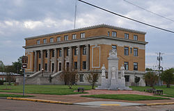
Humphreys County Courthouse
Map of Mississippi highlighting Humphreys County.svg
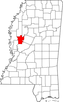
Location within the U.S. state of Mississippi
Mississippi in United States.svg
Mississippi's location within the U.S.
Coordinates: 33°08′N90°31′W / 33.13°N 90.52°W / 33.13; -90.52
CountryFlag of the United States.svg United States
StateFlag of Mississippi.svg  Mississippi
Founded1918
Named for Benjamin G. Humphreys
Seat Belzoni
Largest cityBelzoni
Area
  Total431 sq mi (1,120 km2)
  Land418 sq mi (1,080 km2)
  Water13 sq mi (30 km2)  3.0%
Population
 (2020)
  Total7,785
  Density18/sq mi (7.0/km2)
Time zone UTC−6 (Central)
  Summer (DST) UTC−5 (CDT)
Congressional district 2nd
Website humphreyscounty.ms

Humphreys County is a county located in the U.S. state of Mississippi. As of the 2020 census, the population was 7,785. [1] Its county seat is Belzoni. [2] The county is named for Benjamin G. Humphreys. Humphreys County is Mississippi's newest county, having been formed in 1918. Humphreys County is located in the Mississippi Delta region.

Contents

It was named 'Farm-Raised Catfish Capital of the World' in 1976 by then Governor Cliff Finch, since it produced more farm-raised catfish than any other U.S. county. Forty thousand acres (160 square kilometers) of the county are underwater and used to grow catfish. About 60% of U.S. farm-raised catfish is raised within a 65-mile (105 km) radius of the county seat, Belzoni. The title "Catfish Capital" has also been claimed by Savannah, Tennessee, and Des Allemands, Louisiana.

In March 2023, the towns of Rolling Fork and Silver City were struck by the Tornado outbreak of March 24–25, 2023.

Geography

According to the U.S. Census Bureau, the county has a total area of 431 square miles (1,120 km2), of which 418 sq mi (1,080 km2) is land and 13 sq mi (34 km2) (3.0%) is water. [3]

Major highways

Adjacent counties

National protected area

Demographics

Historical population
CensusPop.Note
1920 19,192
1930 24,72928.9%
1940 26,2576.2%
1950 23,115−12.0%
1960 19,093−17.4%
1970 14,601−23.5%
1980 13,931−4.6%
1990 12,134−12.9%
2000 11,206−7.6%
2010 9,375−16.3%
2020 7,785−17.0%
U.S. Decennial Census [5]
1790–1960 [6] 1900–1990 [7]
1990–2000 [8] 2010–2013 [9]

2020 census

Humphreys County Racial Composition [10]
RaceNum.Perc.
White 1,42318.28%
Black or African American 6,07278.00%
Native American 130.17%
Asian 100.13%
Other/Mixed 1762.26%
Hispanic or Latino 911.17%

As of the 2020 United States Census, there were 7,785 people, 3,186 households, and 2,078 families residing in the county.

2010 census

As of the 2010 United States Census, there were 9,375 people living in the county: 74.5% were Black or African American, 23.5% White, 0.2% Asian, 0.1% Native American, 0.9% of some other race and 0.7% of two or more races, and 2.2% were Hispanic or Latino (of any race).

2000 census

At the 2000 census, [11] there were 11,206 people, 3,765 households and 2,695 families living in the county. The population density was 27 per square mile (10/km2). There were 4,138 housing units at an average density of 10 per square mile (4/km2). The racial makeup of the county was 27.17% White, 71.51% Black or African-American, 0.10% Native American, 0.27% Asian, 0.64% from other races, and 0.31% from two or more races. 1.50% of the population were Hispanic or Latino of any race.

There were 3,765 households, of which 36.60% had children under the age of 18 living with them, 38.30% were married couples living together, 27.70% had a female householder with no husband present, and 28.40% were non-families. Of all households, 24.90% were made up of individuals, and 10.90% had someone living alone who was 65 years of age or older. The average household size was 2.95 and the average family size was 3.54.

Age distribution was 32.70% under the age of 18, 10.70% from 18 to 24, 25.80% from 25 to 44, 18.80% from 45 to 64, and 12.00% who were 65 years of age or older. The median age was 30 years. For every 100 females there were 87.50 males. For every 100 females age 18 and over, there were 78.70 males.

The median household income was $20,566, and the median family income was $23,719. Males had a median income of $24,948 versus $19,201 for females. The per capita income for the county was $10,926. About 32.40% of families and 38.20% of the population were below the poverty line, including 50.30% of those under age 18 and 31.00% of those age 65 or over.

Humphreys County has the seventh-lowest per capita income in Mississippi and the 56th-lowest in the United States.

In April 2019, Propublica identified Humphreys County as the county most intensely audited by the IRS. [12]

Politics

Like most counties in the Delta, Humphreys County is solidly Democratic. A Republican has not won the county since 1972. In 2001 the Humphreys County Sheriff's Department named J. D. Roseman the first black Chief Deputy. In 2008 he became the first black Sheriff of Humphreys County.

United States presidential election results for Humphreys County, Mississippi [13]
Year Republican Democratic Third party
No.%No.%No.%
2020 1,11826.69%3,01672.00%551.31%
2016 1,15127.06%3,07172.21%310.73%
2012 1,29324.81%3,90374.88%160.31%
2008 1,46228.52%3,63470.89%300.59%
2004 1,67934.27%3,16864.65%531.08%
2000 1,62841.28%2,28858.01%280.71%
1996 1,38236.24%2,30560.45%1263.30%
1992 1,72136.75%2,69657.57%2665.68%
1988 2,01842.98%2,64456.32%330.70%
1984 2,30946.99%2,59652.83%90.18%
1980 1,84136.67%2,97059.16%2094.16%
1976 1,44538.29%2,17257.55%1574.16%
1972 2,33469.01%89226.37%1564.61%
1968 2587.11%1,21933.60%2,15159.29%
1964 1,86395.69%844.31%00.00%
1960 23116.24%45932.28%73251.48%
1956 1279.81%57644.51%59145.67%
1952 58940.70%85859.30%00.00%
1948 110.96%171.49%1,11697.55%
1944 352.95%1,15097.05%00.00%
1940 201.85%1,06198.15%00.00%
1936 70.60%1,16499.40%00.00%
1932 101.27%77598.73%00.00%
1928 10.10%1,02099.90%00.00%
1924 334.99%62895.01%00.00%
1920 216.19%31693.22%20.59%

Media

Communities

City

Towns

Unincorporated communities

See also

Related Research Articles

<span class="mw-page-title-main">Humphreys County, Tennessee</span> County in Tennessee, United States

Humphreys County is a county located in the western part of Middle Tennessee, in the U.S. state of Tennessee. As of the 2020 census, the population was 18,990. Its county seat is Waverly.

<span class="mw-page-title-main">Yazoo County, Mississippi</span> County in Mississippi, United States

Yazoo County is a county located in the U.S. state of Mississippi. As of the 2020 census, the population was 26,743. The county seat is Yazoo City. It is named for the Yazoo River, which forms its western border. Its name is said to come from a Choctaw language word meaning "River of Death."

<span class="mw-page-title-main">Washington County, Mississippi</span> County in Mississippi, United States

Washington County is a county located in the U.S. state of Mississippi. As of the 2020 census, the population was 44,922. Its county seat is Greenville. The county is named in honor of the first president of the United States, George Washington. It is located to the Arkansas border.

<span class="mw-page-title-main">Warren County, Mississippi</span> County in Mississippi, United States

Warren County is a county located in the U.S. state of Mississippi. Its western border is formed by the Mississippi River. As of the 2020 census, the population was 44,722. Its county seat is Vicksburg. Established by legislative act of December 22, 1809, Warren County is named for American Revolutionary War officer Joseph Warren.

<span class="mw-page-title-main">Walthall County, Mississippi</span> County in Mississippi, United States

Walthall County is a county located in the U.S. state of Mississippi. As of the 2020 census, the population was 13,884. Its county seat is Tylertown. The county is named after Civil War Confederate general and Mississippi Senator Edward C. Walthall.

<span class="mw-page-title-main">Sunflower County, Mississippi</span> County in Mississippi, United States

Sunflower County is a county located in the U.S. state of Mississippi. As of the 2020 census, the population was 25,971. Its largest city and county seat is Indianola.

<span class="mw-page-title-main">Smith County, Mississippi</span> County in Mississippi, United States

Smith County is a county located in the U.S. state of Mississippi. As of the 2020 census, the population was 14,209. Its county seat is Raleigh. Smith County is a prohibition or dry county.

<span class="mw-page-title-main">Simpson County, Mississippi</span> County in Mississippi, United States

Simpson County is a county located in the U.S. state of Mississippi. Its western border is formed by the Pearl River, an important transportation route in the 19th century. As of the 2020 census, the population was 25,949. The county seat is Mendenhall. The county is named for Josiah Simpson (1787-1817), a territorial judge who also served as a delegate to Mississippi's Constitutional Convention.

<span class="mw-page-title-main">Sharkey County, Mississippi</span> County in Mississippi, United States

Sharkey County is a county located in the U.S. state of Mississippi. Part of the eastern border is formed by the Yazoo River. According to the 2020 census, the population was 3,800, making it the second-least populous county in Mississippi. Its county seat is Rolling Fork. The county is named after William L. Sharkey, the provisional Governor of Mississippi in 1865.

<span class="mw-page-title-main">Lawrence County, Mississippi</span> County in Mississippi, United States

Lawrence County is a county located in the U.S. state of Mississippi. As of the 2020 census, the population was 12,016. Its county seat is Monticello. The county is named for the naval hero James Lawrence.

<span class="mw-page-title-main">Jackson County, Mississippi</span> County in Mississippi, United States

Jackson County is a county located in the U.S. state of Mississippi. As of the 2020 census, the population was 143,252, making it the fifth-most populous county in Mississippi. Its county seat is Pascagoula. The county was named for Andrew Jackson, general in the United States Army and afterward President of the United States.

<span class="mw-page-title-main">George County, Mississippi</span> County in Mississippi, United States

George County is a county located in the U.S. state of Mississippi. As of the 2020 census, the population was 24,350. Its county seat is Lucedale. The county is named for James Z. George, US Senator from Mississippi.

<span class="mw-page-title-main">Wabasha County, Minnesota</span> County in Minnesota, United States

Wabasha County is a county in the U.S. state of Minnesota. As of the 2020 census, the population was 21,387. Its county seat is Wabasha.

<span class="mw-page-title-main">Belzoni, Mississippi</span> City in Mississippi, United States

Belzoni is a city in Humphreys County, Mississippi, United States, in the Mississippi Delta region, on the Yazoo River. The population was 2,235 at the 2010 census. It is the county seat of Humphreys County. It was named for the 19th-century Italian archaeologist/explorer Giovanni Battista Belzoni.

<span class="mw-page-title-main">Isola, Mississippi</span> Town in Mississippi, United States

Isola is a town in Humphreys County, Mississippi, United States, on the banks of Lake Dawson. The population was 713 at the 2010 census, down from 768 at the 2000 census.

<span class="mw-page-title-main">Louise, Mississippi</span> Town in Mississippi, United States

Louise is a town in Humphreys County, Mississippi. The population was 199 at the 2010 census, down from 315 at the 2000 census.

<span class="mw-page-title-main">Silver City, Mississippi</span> Town in Mississippi, United States

Silver City is a town in Humphreys County, Mississippi, United States. The population was 337 at the 2010 census, unchanged from the 2000 census.

<span class="mw-page-title-main">Morgan City, Mississippi</span> Town in Mississippi, United States

Morgan City, Mississippi is a town in Leflore County along Mississippi Highway 7. The population was 255 at the 2010 census, down from 305 at the 2000 census. It is part of the Greenwood, Mississippi micropolitan area.

<span class="mw-page-title-main">Inverness, Mississippi</span> Town in Mississippi, United States

Inverness is a town in Sunflower County, Mississippi, United States. The population was 1,019 at the 2010 census. As the town had the largest cotton gin in the Delta, it served as a gathering place for farmers from the region when they brought their cotton for processing. The town was heavily damaged by a tornado in 1971.

<span class="mw-page-title-main">Moorhead, Mississippi</span> City in Mississippi, United States

Moorhead is a city in Sunflower County, Mississippi, United States. As of the 2010 census, the city population was 2,405.

References

  1. "Census - Geography Profile: Humphreys County, Mississippi". United States Census Bureau . Retrieved January 8, 2023.
  2. "Find a County". National Association of Counties. Archived from the original on May 31, 2011. Retrieved June 7, 2011.
  3. "2010 Census Gazetteer Files". United States Census Bureau. August 22, 2012. Archived from the original on September 28, 2013. Retrieved November 4, 2014.
  4. "Sky Lake Wildlife Boardwalk". Mississippi Fish and Wildlife Foundation. Retrieved April 9, 2022.
  5. "U.S. Decennial Census". United States Census Bureau. Retrieved November 4, 2014.
  6. "Historical Census Browser". University of Virginia Library. Retrieved November 4, 2014.[ dead link ]
  7. "Population of Counties by Decennial Census: 1900 to 1990". United States Census Bureau. Retrieved November 4, 2014.
  8. "Census 2000 PHC-T-4. Ranking Tables for Counties: 1990 and 2000" (PDF). United States Census Bureau. Archived (PDF) from the original on March 27, 2010. Retrieved November 4, 2014.
  9. "State & County QuickFacts". United States Census Bureau. Archived from the original on June 7, 2011. Retrieved September 3, 2013.
  10. "Explore Census Data". data.census.gov. Retrieved December 7, 2021.
  11. "U.S. Census website". United States Census Bureau . Retrieved January 31, 2008.
  12. Where in The U.S. Are You Most Likely to Be Audited by the IRS? By Paul Kiel and Hannah Fresques, ProPublica. Retrieved April 1, 2019
  13. Leip, David. "Dave Leip's Atlas of U.S. Presidential Elections". uselectionatlas.org. Retrieved March 4, 2018.
  14. "about us Archived 2012-03-12 at the Wayback Machine ." The Enterprise-Tocsin . Retrieved on March 4, 2011. "Our office is located at 114 Main St, Indianola."

Coordinates: 33°08′N90°31′W / 33.13°N 90.52°W / 33.13; -90.52