Silver City, Mississippi

Last updated

Silver City, Mississippi
SilverCityJackReedSign.jpg
Welcome sign (2012)
Humphreys County Mississippi Incorporated and Unincorporated areas Silver City Highlighted.svg
Location within Humphreys County and Mississippi
Coordinates: 33°5′43″N90°29′45″W / 33.09528°N 90.49583°W / 33.09528; -90.49583
Country United States
State Mississippi
County Humphreys
Area
[1]
  Total0.63 sq mi (1.62 km2)
  Land0.60 sq mi (1.56 km2)
  Water0.02 sq mi (0.06 km2)
Elevation
108 ft (33 m)
Population
 (2021)
  Total217
  Estimate 
(2025)
197
  Density369.21/sq mi (142.59/km2)
Time zone UTC-6 (Central (CST))
  Summer (DST) UTC-5 (CDT)
ZIP code
39166
Area code 662
FIPS code 28-67920
GNIS ID 677790

Silver City is a town in Humphreys County, Mississippi, United States. The population was 217 at the 2021 census, [2] a massive decline from the 2000 census.

Contents

History

The town was first named "Palmetto Home", after a nearby plantation. [3]

2023 tornado

On March 24, 2023, a destructive wedge tornado directly hit Silver City. Numerous people were injured and several buildings were destroyed. The same destructive tornado had previously hit the towns of Rolling Fork and Midnight. The tornado was rated high-end EF4, although only EF2 damage occurred in the town. [4] [5]

Geography

Silver City is located in central Humphreys County at 33°5′43″N90°29′45″W / 33.09528°N 90.49583°W / 33.09528; -90.49583 (33.095335, -90.495814), [6] in the Mississippi Delta region. It is bordered to the east by the Yazoo River. U.S. Route 49W passes through the town, leading north 7 miles (11 km) to Belzoni, the county seat, and south 20 miles (32 km) to Yazoo City. Mississippi Highway 149, an old alignment of US 49W, leads southwest from Silver City 10 miles (16 km) to Louise.

According to the United States Census Bureau, Silver City has a total area of 0.62 square miles (1.6 km2), of which 0.02 square miles (0.06 km2), or 3.56%, are water. [2]

Demographics

Historical population
CensusPop.Note
1880 45
1910 341
1920 322−5.6%
1930 36112.1%
1940 3908.0%
1950 381−2.3%
1960 43113.1%
1970 370−14.2%
1980 3782.2%
1990 348−7.9%
2000 337−3.2%
2010 3370.0%
2020 223−33.8%
U.S. Decennial Census [7]

As of the census [8] of 2000, there were 337 people, 124 households, and 76 families residing in the town. The population density was 553.7 inhabitants per square mile (213.8/km2). There were 133 housing units at an average density of 218.5 per square mile (84.4/km2). The racial makeup of the town was 21.66% White and 78.34% African American.

There were 124 households, out of which 33.1% had children under the age of 18 living with them, 31.5% were married couples living together, 24.2% had a female householder with no husband present, and 38.7% were non-families. 36.3% of all households were made up of individuals, and 15.3% had someone living alone who was 65 years of age or older. The average household size was 2.72 and the average family size was 3.59.

In the town, the population was spread out, with 30.6% under the age of 18, 9.2% from 18 to 24, 24.0% from 25 to 44, 22.0% from 45 to 64, and 14.2% who were 65 years of age or older. The median age was 36 years. For every 100 females, there were 87.2 males. For every 100 females age 18 and over, there were 68.3 males.

The median income for a household in the town was $22,083, and the median income for a family was $20,000. Males had a median income of $23,125 versus $16,250 for females. The per capita income for the town was $15,459. About 36.6% of families and 49.3% of the population were below the poverty line, including 70.8% of those under age 18 and 38.6% of those age 65 or over.

Education

Silver City is served by the Humphreys County School District.

Notable people

Related Research Articles

<span class="mw-page-title-main">Yazoo County, Mississippi</span> County in Mississippi, United States

Yazoo County is a county located in the U.S. state of Mississippi. As of the 2020 census, the population was 26,743. The county seat is Yazoo City. It is named for the Yazoo River, which forms its western border. Its name is said to come from a Choctaw language word meaning "River of Death".

<span class="mw-page-title-main">Warren County, Mississippi</span> County in Mississippi, United States

Warren County is a county located in the U.S. state of Mississippi. Its western border is formed by the Mississippi River. As of the 2020 census, the population was 44,722. Its county seat is Vicksburg. Established by legislative act of December 22, 1809, Warren County is named for American Revolutionary War officer Joseph Warren.

<span class="mw-page-title-main">Sharkey County, Mississippi</span> County in Mississippi, United States

Sharkey County is a county located in the U.S. state of Mississippi. Part of the eastern border is formed by the Yazoo River. According to the 2020 census, the population was 3,800, making it the second-least populous county in Mississippi, after Issaquena County. Its county seat is Rolling Fork. The county is named after William L. Sharkey, the provisional Governor of Mississippi in 1865.

<span class="mw-page-title-main">Humphreys County, Mississippi</span> County in Mississippi, United States

Humphreys County is a county located in the U.S. state of Mississippi. As of the 2020 census, the population was 7,785. Its county seat is Belzoni. The county is named for Benjamin G. Humphreys. Humphreys County is Mississippi's newest county, having been formed in 1918. Humphreys County is located in the Mississippi Delta region.

<span class="mw-page-title-main">Corcoran, Minnesota</span> City in Minnesota, United States

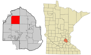
Corcoran is a rural city in Hennepin County, Minnesota, United States. The population was 5,379 at the 2010 census.

<span class="mw-page-title-main">Derma, Mississippi</span> Town in Mississippi, United States

Derma is a town in Calhoun County, Mississippi, United States. The population was 1,025 at the 2010 census.

<span class="mw-page-title-main">Isola, Mississippi</span> Town in Mississippi, United States

Isola is a town in Humphreys County, Mississippi, United States, on the banks of Lake Dawson. The population was 713 at the 2010 census, down from 768 at the 2000 census.

<span class="mw-page-title-main">Louise, Mississippi</span> Town in Mississippi, United States

Louise is a town in Humphreys County, Mississippi. The population was 199 at the 2010 census, down from 315 at the 2000 census.

<span class="mw-page-title-main">Itta Bena, Mississippi</span> City in Mississippi, United States

Itta Bena is a city in Leflore County, Mississippi, United States. The population was 2,049 at the 2010 census. The town's name is derived from the Choctaw phrase iti bina, meaning "forest camp". Itta Bena is part of the Greenwood, Mississippi micropolitan area. It developed as a trading center of an area of cotton plantations.

<span class="mw-page-title-main">Morgan City, Mississippi</span> Town in Mississippi, United States

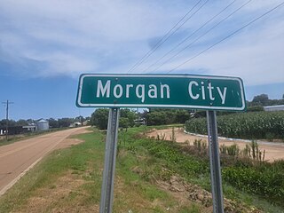
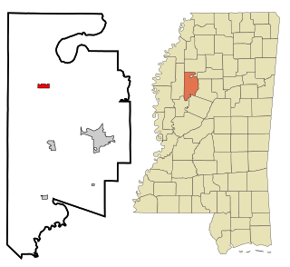
Morgan City, Mississippi is a town in Leflore County along Mississippi Highway 7. The population was 255 at the 2010 census, down from 305 at the 2000 census. It is part of the Greenwood, Mississippi micropolitan area.

<span class="mw-page-title-main">Schlater, Mississippi</span> Town in Mississippi, United States

Schlater is a town in Leflore County, Mississippi, United States. The population was 310 at the 2010 census, down from 388 at the 2000 census. It is part of the Greenwood, Mississippi micropolitan area.

<span class="mw-page-title-main">Rolling Fork, Mississippi</span> City and county seat in Mississippi, United States

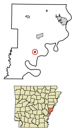
Rolling Fork is a city and county seat of Sharkey County, Mississippi, United States. As of the 2020 census, the population of the town was 1,883.

<span class="mw-page-title-main">Moorhead, Mississippi</span> City in Mississippi, United States

Moorhead is a city in Sunflower County, Mississippi, United States. As of the 2010 census, the city population was 2,405.

<span class="mw-page-title-main">Bentonia, Mississippi</span> Town in Mississippi, United States

Bentonia is a town in Yazoo County, Mississippi, United States. The population as of the 2020 census was 319.

<span class="mw-page-title-main">Eden, Mississippi</span> Village in Mississippi, United States

Eden is a village in Yazoo County, Mississippi. Per the 2020 Census, the population was 133.

<span class="mw-page-title-main">Yazoo City, Mississippi</span> City in Mississippi, United States

Yazoo City is a city in Yazoo County, Mississippi, United States. It was named after the Yazoo River, which, in turn was named by the French explorer Robert La Salle in 1682 as "Rivière des Yazous" in reference to the Yazoo tribe living near the river's mouth. It is the county seat of Yazoo County and the principal city of the Yazoo City Micropolitan Statistical Area, which is part of the larger Jackson–Yazoo City Combined Statistical Area. According to the 2010 census, the population was 11,403. The most important industry in 2021 is a group of federal prisons.

<span class="mw-page-title-main">Ruleville, Mississippi</span> City in Mississippi, United States

Ruleville is a city in Sunflower County, Mississippi, United States, in the Mississippi Delta region. The population was 3,007 at the 2010 census. It is the second-largest community in the rural county.

<span class="mw-page-title-main">Wheatland, Pennsylvania</span> Borough in Pennsylvania, United States

Wheatland is a borough in Mercer County, Pennsylvania, United States, along the Shenango River. The population was 583 at the 2020 census. It is part of the Hermitage micropolitan area.

<span class="mw-page-title-main">Athelstane, Wisconsin</span> Town in Wisconsin, United States

Athelstane is a town in Marinette County, Wisconsin, United States. The population was 601 at the 2000 census. The unincorporated community of Athelstane is located in the town.

<span class="mw-page-title-main">Midnight, Mississippi</span> Unincorporated community in Mississippi, United States

Midnight is an unincorporated community located in Humphreys County, Mississippi, United States. Midnight is approximately 5 miles (8.0 km) north of Louise and 5 miles (8.0 km) southwest of Silver City along Mississippi Highway 149. Although Midnight is unincorporated, it has a zip code of 39115.

References

  1. "2020 U.S. Gazetteer Files". United States Census Bureau. Retrieved July 24, 2022.
  2. 1 2 "Geographic Identifiers: 2010 Census Summary File 1 (G001): Silver City town, Mississippi". American Factfinder. U.S. Census Bureau. Archived from the original on February 13, 2020. Retrieved August 21, 2017.
  3. McElvaine, Robert S. (1988). Mississippi: The WPA Guide to the Magnolia State. University Press of Mississippi. ISBN   9781604732894.
  4. Will McDuffie; Peter Charalambous; Kevin Shalvey (March 25, 2023). "19 dead as 'destructive' tornado, storms batter Mississippi, officials say". ABC News. Retrieved March 25, 2023.
  5. Charalambous, Peter; Shalvey, Kevin; El-Bawab, Nadine (March 25, 2023). "'Leveled': Responders, residents describe horror of Mississippi tornado destruction". ABC News . Retrieved March 25, 2023.
  6. "US Gazetteer files: 2010, 2000, and 1990". United States Census Bureau. February 12, 2011. Retrieved April 23, 2011.
  7. "Census of Population and Housing". Census.gov. Retrieved June 4, 2015.
  8. "U.S. Census website". United States Census Bureau . Retrieved January 31, 2008.