Marion County, Mississippi

Last updated

Marion County
Marion County Mississippi Courthouse.jpg
Marion County courthouse in Columbia
Flag of Marion County, Mississippi.svg
Map of Mississippi highlighting Marion County.svg
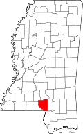
Location within the U.S. state of Mississippi
Mississippi in United States.svg
Mississippi's location within the U.S.
Coordinates: 31°14′N89°49′W / 31.23°N 89.82°W / 31.23; -89.82
CountryFlag of the United States.svg United States
StateFlag of Mississippi.svg  Mississippi
Founded1811
Named for Francis Marion
Seat Columbia
Largest cityColumbia
Area
  Total
549 sq mi (1,420 km2)
  Land542 sq mi (1,400 km2)
  Water6.2 sq mi (16 km2)  1.1%
Population
 (2020)
  Total
24,441
  Estimate 
(2023)
24,224 Decrease2.svg
  Density45/sq mi (17/km2)
Time zone UTC−6 (Central)
  Summer (DST) UTC−5 (CDT)
Congressional district 3rd
Website www.marioncountyms.com

Marion County is a county located in the U.S. state of Mississippi. As of the 2020 census, the population was 24,441. [1] Its county seat is Columbia. [2] Marion County is named for American Revolutionary War guerrilla leader Francis Marion also known as The Swamp Fox. [3]

Contents

Geography

According to the U.S. Census Bureau, the county has a total area of 549 square miles (1,420 km2), of which 542 square miles (1,400 km2) is land and 6.2 square miles (16 km2) (1.1%) is water. [4]

Major highways

Adjacent counties

Demographics

Historical population
CensusPop.Note
1820 3,116
1830 3,69118.5%
1840 3,8303.8%
1850 4,41015.1%
1860 4,6866.3%
1870 4,211−10.1%
1880 6,90163.9%
1890 9,53238.1%
1900 13,50141.6%
1910 15,59915.5%
1920 17,1449.9%
1930 19,92316.2%
1940 24,08520.9%
1950 23,967−0.5%
1960 23,293−2.8%
1970 22,871−1.8%
1980 25,70812.4%
1990 25,544−0.6%
2000 25,5950.2%
2010 27,0885.8%
2020 24,441−9.8%
2023 (est.)24,224 [5] −0.9%
U.S. Decennial Census [6]
1790-1960 [7] 1900-1990 [8]
1990-2000 [9] 2010-2013 [10]
Marion County racial composition as of 2020 [11]
RaceNum.Perc.
White (non-Hispanic)15,72164.32%
Black or African American (non-Hispanic)7,58331.03%
Native American 420.17%
Asian 650.27%
Other/Mixed 6242.55%
Hispanic or Latino 4061.66%

As of the 2020 United States census, there were 24,441 people, 9,483 households, and 5,863 families residing in the county.

Government and infrastructure

The Mississippi Department of Human Services's Division of Youth Services operated the Columbia Training School in unincorporated Marion County. The facility was closed in 2008. [12] [13]

United States presidential election results for Marion County, Mississippi [14]
Year Republican Democratic Third party(ies)
No.%No.%No.%
2024 7,87470.25%3,21528.68%1191.06%
2020 8,27367.94%3,78731.10%1170.96%
2016 7,83667.01%3,67731.45%1801.54%
2012 8,23764.71%4,39334.51%990.78%
2008 8,51365.43%4,42233.99%750.58%
2004 7,99966.95%3,88832.54%600.50%
2000 6,79661.79%4,11437.41%880.80%
1996 5,02350.39%4,33443.48%6116.13%
1992 5,77649.74%4,65440.08%1,18310.19%
1988 7,01961.87%4,24037.38%850.75%
1984 7,35566.11%3,75733.77%130.12%
1980 5,21848.73%5,36650.12%1231.15%
1976 5,30049.36%5,28349.20%1541.43%
1972 6,80579.40%1,69319.75%720.84%
1968 7639.16%1,72220.66%5,84870.18%
1964 5,46991.55%5058.45%00.00%
1960 69822.92%1,08235.53%1,26541.54%
1956 61120.15%1,75157.75%67022.10%
1952 1,42035.35%2,59764.65%00.00%
1948 491.79%2057.47%2,49190.75%
1944 542.16%2,44197.84%00.00%
1940 452.11%2,08397.89%00.00%
1936 371.88%1,93298.07%10.05%
1932 943.71%2,42995.97%80.32%
1928 52636.33%92263.67%00.00%
1924 998.70%1,03991.30%00.00%
1920 14318.52%61379.40%162.07%
1916 516.01%79293.40%50.59%
1912 122.51%43891.44%296.05%

Communities

City

Census-designated places

Unincorporated communities

Education

There are two school districts in the county: Columbia School District and Marion County School District. [17]

The county is in the service area of Pearl River Community College. [18]

Notable people

See also

References

  1. "Census - Geography Profile: Marion County, Mississippi". United States Census Bureau . Retrieved January 14, 2023.
  2. "Find a County". National Association of Counties. Retrieved June 7, 2011.
  3. Gannett, Henry (1905). The Origin of Certain Place Names in the United States. U.S. Government Printing Office. p.  200.
  4. "2010 Census Gazetteer Files". United States Census Bureau. August 22, 2012. Archived from the original on September 28, 2013. Retrieved November 6, 2014.
  5. "Annual Estimates of the Resident Population for Counties: April 1, 2020 to July 1, 2023". United States Census Bureau. Retrieved April 5, 2024.
  6. "U.S. Decennial Census". United States Census Bureau. Retrieved November 6, 2014.
  7. "Historical Census Browser". University of Virginia Library. Retrieved November 6, 2014.
  8. "Population of Counties by Decennial Census: 1900 to 1990". United States Census Bureau. Retrieved November 6, 2014.
  9. "Census 2000 PHC-T-4. Ranking Tables for Counties: 1990 and 2000" (PDF). United States Census Bureau. Archived (PDF) from the original on March 27, 2010. Retrieved November 6, 2014.
  10. "State & County QuickFacts". United States Census Bureau. Archived from the original on June 7, 2011. Retrieved September 4, 2013.
  11. "Explore Census Data". data.census.gov. Retrieved December 16, 2021.
  12. U.S. Census Bureau profile of Columbia, MS . Retrieved on July 21, 2010.
  13. "Public Appearance Calendar Governor Ronnie Musgrove For the Week of December 31, 2001 Archived October 16, 2010, at the Wayback Machine ". Mississippi Department of Archives and History. Retrieved on July 21, 2010. "Columbia Training School 1730 Highway 44 Columbia, MS."
  14. Leip, David. "Dave Leip's Atlas of U.S. Presidential Elections". uselectionatlas.org. Retrieved March 3, 2018.
  15. Society, Marion County Historical (February 20, 2012). Marion County. Arcadia Publishing. ISBN   9780738591933 via Google Books.
  16. Pearlman, Jeff (August 28, 2012). Sweetness: The Enigmatic Life of Walter Payton. Penguin Publishing Group. ISBN   9781592407378 via Google Books.
  17. "2020 CENSUS - SCHOOL DISTRICT REFERENCE MAP: Marion County, MS" (PDF). U.S. Census Bureau . Retrieved September 27, 2024. - Text list
  18. "2014-2016 Catalog" (PDF). Pearl River Community College. Archived from the original (PDF) on August 7, 2015. Retrieved April 13, 2022.
  19. Marion County. Arcadia. 2012. ISBN   9780738591933.

31°14′N89°49′W / 31.23°N 89.82°W / 31.23; -89.82