Pine Belt (Mississippi)

Last updated
Mississippi's Pine Belt Region Mississippi Locator Map (Pine Belt Region).png
Mississippi's Pine Belt Region

The Pine Belt, also known as the Piney Woods , is a region in Southeast Mississippi. The region gets its name from the longleaf pine trees that are abundant in the region. [1] The Pine Belt includes 9 counties: Covington, Forrest, Greene, Jefferson Davis, Jones, Lamar, Marion, Perry, and Wayne. [2]

Contents

History

Before the arrival of Europeans, the area that would later become the state of Mississippi was populated by several Native American tribes, including the Natchez and Pascagoula in the Pine Belt. [3] [4] The population of these Native Americans declined as a result of armed conflicts with the Europeans, attrition from diseases, or coalescence with other tribes. [4] [5]

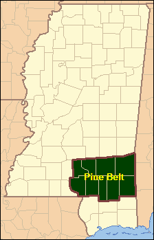
In 1817, the western portion of the Mississippi Territory was admitted to the Union as the State of Mississippi. Yet, the vast longleaf pine resource in Mississippi's Pine Belt remained mostly undisturbed, because there was no efficient system for transporting cut timber to sawmills for processing into lumber. That changed in the late 1800s, when railroads were built throughout the Pine Belt. These railroads provided an inexpensive means for moving passengers as well as logs and lumber, and opened Mississippi's Pine Belt to both industrial growth and community development. Notable railway construction during this era included the Gulf and Ship Island Railroad; New Orleans and Northeastern Railroad; and the Mobile, Jackson and Kansas City Railroad. [6] The Pine Belt's booming timber industry ended around 1930, when the virgin pine forests were depleted. [6]

As World War I raged in Europe, military training sites were being created throughout the United States. [7] As part of that effort, one of those training sites was established in the Pine Belt south of Hattiesburg in 1917. Over time, that training site transformed into Camp Shelby Joint Forces Training Center. [1] Camp Shelby is the largest state owned military training facility in the United States and covers more than 134,000 acres (54,000 ha). [8] [9]

Geography

As of 2020, Mississippi's Pine Belt had a population of 306,672 [10] and an area of about 5,200 mi2 (13,400 km2). In the U.S. House of Representatives, the area is split between Mississippi's 3rd and 4th congressional districts.

Principal cities and towns

The following are the 10 most populous cities and towns in the region.

City or townCountyPopulation
(2020 census)
Hattiesburg Forrest (county seat), Lamar 48,730
Laurel Jones (county seat)17,161
Petal Forrest 11,010
Columbia Marion (county seat)5,864
Ellisville Jones (county seat)4,652
Waynesboro Wayne (county seat)4,567
Leakesville Greene (county seat)3,775
Collins Covington (county seat)2,342
Purvis Lamar (county seat)1,909
Sumrall Lamar 1,765

Education

Universities
Community colleges

Media

Newspapers, magazines, and journals
Television

Transportation

Airports
Interstates
Highways

Notable people

See also

Related Research Articles

<span class="mw-page-title-main">Jones County, Mississippi</span> County in Mississippi, United States

Jones County is in the southeastern portion of the U.S. state of Mississippi. As of the 2020 census, the population was 67,246. Its county seats are Laurel and Ellisville.

<span class="mw-page-title-main">Scouting in Mississippi</span> Scouting in Mississippi

Scouting in Mississippi has a long history, from the 1910s to the present day, serving thousands of youth in programs that suit the environment in which they live.

<span class="mw-page-title-main">Laurel, Mississippi</span> City in Mississippi, United States

Laurel is a city in and the second county seat of Jones County, Mississippi, United States. As of the 2020 census, the city had a population of 17,161. Laurel is northeast of Ellisville, the first county seat, which contains the first county courthouse. It has the second county courthouse, as Jones County has two judicial districts. Laurel is the headquarters of the Jones County Sheriff's Department, which administers in the county. Laurel is the principal city of a micropolitan statistical area named for it. Major employers include Howard Industries, Sanderson Farms, Masonite International, Family Health Center, Howse Implement, Thermo-Kool, and South Central Regional Medical Center. Laurel is home to the Lauren Rogers Museum of Art, Mississippi's oldest art museum, established by the family of Lauren Eastman Rogers.

<span class="mw-page-title-main">Purvis, Mississippi</span> City in Mississippi, United States

Purvis is a U.S. city in and the county seat of Lamar County, Mississippi. It is part of the Hattiesburg, Mississippi Metropolitan Statistical Area. The population was 2,175 at the 2010 census. The Town of Purvis was incorporated on February 25, 1888 and was founded by and named after Thomas Melville Purves, originally of Marion County, Alabama. Purves, born March 8, 1820, was a second generation Scottish-American; his grandfather emigrated to Charleston, South Carolina in 1765.

<span class="mw-page-title-main">Sumrall, Mississippi</span> Town in Mississippi, United States

Sumrall is a town in Lamar County, Mississippi. It is part of the Hattiesburg, Mississippi Metropolitan Statistical Area. The population was 1,421 at the 2010 census.

<span class="mw-page-title-main">Picayune, Mississippi</span> City in Mississippi, United States

Picayune is the largest city in Pearl River County, Mississippi, United States. The population was 11,885 at the 2020 census. The city is located approximately 45 miles (72 km) from New Orleans, Hattiesburg, and Gulfport–Biloxi. The Stennis Space Center is 10 miles (16 km) away. Picayune is part of the New Orleans–Metairie–Hammond combined statistical area.

<span class="mw-page-title-main">Hattiesburg, Mississippi</span> City in Mississippi, United States

Hattiesburg is the 5th most populous city in the U.S. state of Mississippi, located primarily in Forrest County and extending west into Lamar County. The city population was 45,989 at the 2010 census, with the population now being 48,730 in 2020. Hattiesburg is the principal city of the Hattiesburg Metropolitan Statistical Area, which encompasses Covington, Forrest, Lamar, and Perry counties. The city is located in the Pine Belt region.

<span class="mw-page-title-main">Northeast Texas</span> Region in Texas, United States

Northeast Texas is a cultural and geographic region in the northeast corner of the U.S. state of Texas. Geographically centered on two metropolitan areas strung along Interstate 20—Tyler in the west and Longview/Marshall to the east, the areas of Greenville, Mount Pleasant, Sulphur Springs, Paris, and Texarkana in the north primarily along Interstate 30, and Jacksonville and Palestine to the south are also major cities within the region. Most of Northeast Texas is included in the interstate region of the Ark-La-Tex.

<span class="mw-page-title-main">Mississippi Highway 42</span> State Highway in Mississippi

Mississippi Highway 42 is a state highway in southern Mississippi. MS 42 runs in an east/west direction for 116.0 miles (186.7 km), serving seven Mississippi counties: Wayne, Greene, Perry, Forrest, Lamar, Jefferson Davis, and Lawrence. Portions of this highway run parallel to the Longleaf Trace. The length of highway between Interstate 59 and U.S. Highway 11 in Forrest County, just outside Petal is known as the Evelyn Gandy Parkway.

<span class="mw-page-title-main">Hattiesburg metropolitan area</span>

The Hattiesburg Metropolitan Statistical Area is a metropolitan statistical area (MSA) in southeastern Mississippi that covers four counties - Covington, Forrest, Lamar, and Perry. The MSA's principal city is Hattiesburg. The 2010 census placed the Hattiesburg MSA's population at 162,410, though estimates as of 2019 indicate the population has increased to 168,849. The area is part of the geographical region known as the Pine Belt, famous for its abundance of longleaf pine trees. The Hattiesburg MSA is part of the larger Hattiesburg-Laurel Combined Statistical Area.

<span class="mw-page-title-main">McHenry, Mississippi</span> Unincorporated community in Mississippi, United States

McHenry, is an unincorporated community in southern Stone County, Mississippi. It is situated approximately 10 miles (16 km) south of Wiggins and 3 miles (4.8 km) north of Saucier. The community is part of the Gulfport-Biloxi metropolitan area.

<span class="mw-page-title-main">Index of Mississippi-related articles</span>

The following is an alphabetical list of articles related to the U.S. state of Mississippi.

A Mississippi Landmark is a building officially nominated by the Mississippi Department of Archives and History and approved by each county's chancery clerk. The Mississippi Landmark designation is the highest form of recognition bestowed on properties by the state of Mississippi, and designated properties are protected from changes that may alter the property's historic character. Currently there are 890 designated landmarks in the state. Mississippi Landmarks are spread out between eighty-one of Mississippi's eighty-two counties; only Issaquena County has no such landmarks.

The Finkbine-Guild Lumber Company was established to harvest and market the virgin longleaf pine stands of southern Mississippi during the early 20th century. The main sawmills were located in Wiggins and D'Lo, Mississippi. When the local timber supply dwindled, the company tried to utilize redwood trees from California, but that operation failed because of high transportation costs. Other attempts were made at promoting a more diversified use of the cutover timberlands; some ventures were successful while others were not.

<span class="mw-page-title-main">Mississippi Department of Archives and History</span> Mississippi state government agency

Mississippi Department of Archives and History (MDAH) is a state agency founded in 1902. It is the official archive of the Mississippi Government.

<span class="mw-page-title-main">Gulf and Ship Island Railroad</span>

The Gulf and Ship Island Railroad (G&SI) was constructed in the state of Mississippi, USA, at the turn of the 20th century to open a vast expanse of southern yellow pine forests for commercial harvest. In spite of economic uncertainty, entrepreneurs William H. Hardy and Joseph T. Jones successfully completed railroad construction. The railroad resulted in the development of a seaport and expansion of cities along its route.

<span class="mw-page-title-main">George Austin McHenry</span> Mississippi pioneer and physician

George Austin McHenry was an American military officer, Mississippi pioneer, physician, and entrepreneur.

<span class="mw-page-title-main">Harrison Experimental Forest</span> Mississippi experimental forest facility

Harrison Experimental Forest is an experimental forest facility operated by the Southern Research Station (SRS) of the United States Forest Service in Harrison County, Mississippi. The experimental forest is located within the De Soto National Forest about 25 mi (40 km) north of Gulfport, Mississippi off Old Mississippi Highway 67.

References

  1. 1 2 "The Pine Belt | U.S. Congressman Steven Palazzo". palazzo.house.gov. Retrieved 2021-07-17.
  2. "Regions | Senator Cindy Hyde-Smith". www.hydesmith.senate.gov. Retrieved 2021-07-17.
  3. "Where Is The Mississippi Pine Belt?". WorldAtlas. 25 January 2019. Retrieved 2021-07-18.
  4. 1 2 "MS Archaeology Trails|Indian Tribes of Mississippi". trails.mdah.ms.gov. Retrieved 2021-07-18.
  5. Barnett, Jim (August 2000). "The Natchez Indians|Mississippi History Now". www.mshistorynow.mdah.ms.gov. Retrieved 2021-07-18.
  6. 1 2 Howe, Tony (May 2001). "Growth of the Lumber Industry, (1840 to 1930) | Mississippi History Now". Archived from the original on 2010-03-16. Retrieved 2021-07-18.
  7. Garamone, Jim (March 29, 2017). "World War I: Building the American Military". U.S. Department of Defense. Retrieved 2021-07-18.
  8. "Camp Shelby Army Base in Hattiesburg, MS | MilitaryBases.com". Military Bases. Retrieved 2021-07-17.
  9. "Camp Shelby Joint Forces Training Center". ms.ng.mil. Retrieved 2021-07-17.
  10. "Pine Belt Region vs. Mississippi Comparative Trends Analysis: Population Growth and Change, 1969-2020". Mississippi Regional Economic Analysis Project. Retrieved 2022-07-10.

31°07′22″N88°56′12″W / 31.122799°N 88.936746°W / 31.122799; -88.936746