Clay County, Mississippi

Last updated

Clay County
City Hall, West Point, MS 02.JPG
Map of Mississippi highlighting Clay County.svg
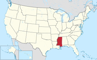
Location within the U.S. state of Mississippi
Mississippi in United States.svg
Mississippi's location within the U.S.
Coordinates: 33°39′N88°46′W / 33.65°N 88.77°W / 33.65; -88.77
CountryFlag of the United States.svg United States
StateFlag of Mississippi.svg  Mississippi
Founded1871
Named for Henry Clay
Seat West Point
Largest cityWest Point
Area
  Total
416 sq mi (1,080 km2)
  Land410 sq mi (1,100 km2)
  Water5.9 sq mi (15 km2)  1.4%
Population
 (2020)
  Total
18,636
  Estimate 
(2023)
18,206 Decrease2.svg
  Density45/sq mi (17/km2)
Time zone UTC−6 (Central)
  Summer (DST) UTC−5 (CDT)
Congressional district 1st
Website www.claycountyms.com/index.php/

Clay County is a county in the U.S. state of Mississippi. As of the 2020 census, the population was 18,636. [1] Its county seat is West Point. [2] Its name is in honor of American statesman Henry Clay, [3] member of the United States Senate from Kentucky and United States Secretary of State in the 19th century. J. Wesley Caradine, an African American, was the first state representative for Clay County after it was established in 1871. [4] The federal government formerly designated Clay County as the West Point Micropolitan Statistical Area, but the county lost that status in 2013. [5] It is part of the Golden Triangle region of the state. [6]

Contents

Geography

According to the U.S. Census Bureau, the county has a total area of 416 square miles (1,080 km2), of which 410 square miles (1,100 km2) is land and 5.9 square miles (15 km2) (1.4%) is water. [7]

Major highways

Adjacent counties

National protected area

Demographics

Historical population
CensusPop.Note
1880 17,367
1890 18,6077.1%
1900 19,5635.1%
1910 20,2033.3%
1920 17,490−13.4%
1930 17,9312.5%
1940 19,0306.1%
1950 17,757−6.7%
1960 18,9336.6%
1970 18,840−0.5%
1980 21,08211.9%
1990 21,1200.2%
2000 21,9794.1%
2010 20,634−6.1%
2020 18,636−9.7%
2023 (est.)18,206 [8] −2.3%
U.S. Decennial Census [9]
1790-1960 [10] 1900-1990 [11]
1990-2000 [12] 2010-2013 [13]

2020 census

Clay County Racial Composition [14]
RaceNum.Perc.
White 7,19638.61%
Black or African American 10,78557.87%
Native American 350.19%
Asian 570.31%
Pacific Islander 10.01%
Other/Mixed 3762.02%
Hispanic or Latino 1861.0%

As of the 2020 United States Census, there were 18,636 people, 7,618 households, and 4,841 families residing in the county.

2010 census

As of the 2010 United States Census, there were 20,634 people living in the county. 58.2% were Black or African American, 40.5% White, 0.2% Asian, 0.1% Native American, 0.3% of some other race and 0.6% of two or more races. 1.0% were Hispanic or Latino (of any race).

2000 census

As of the census [15] of 2000, there were 21,979 people, 8,152 households, and 5,885 families living in the county. The population density was 54 people per square mile (21 people/km2). There were 8,810 housing units at an average density of 22 per square mile (8.5/km2). The racial makeup of the county was 56.33% Black or African American, 42.82% White, 0.05% Native American, 0.16% Asian, 0.01% Pacific Islander, 0.21% from other races, and 0.42% from two or more races. 0.86% of the population were Hispanic or Latino of any race.

According to the census [15] of 2000, the largest ancestry groups in Clay County were African 56.3%, English 35% and Scots-Irish 4.5%.

There were 8,152 households, out of which 35.70% had children under the age of 18 living with them, 45.80% were married couples living together, 22.40% had a female householder with no husband present, and 27.80% were non-families. 25.50% of all households were made up of individuals, and 11.00% had someone living alone who was 65 years of age or older. The average household size was 2.64 and the average family size was 3.19.

In the county, the population was spread out, with 28.80% under the age of 18, 10.40% from 18 to 24, 26.50% from 25 to 44, 21.10% from 45 to 64, and 13.10% who were 65 years of age or older. The median age was 34 years. For every 100 females there were 89.10 males. For every 100 females age 18 and over, there were 83.60 males.

The median income for a household in the county was $27,372, and the median income for a family was $35,461. Males had a median income of $30,038 versus $19,473 for females. The per capita income for the county was $14,512. About 19.20% of families and 23.50% of the population were below the poverty line, including 34.20% of those under age 18 and 21.90% of those age 65 or over.

Law enforcement

Clay County has a sheriff law enforcement system.

Education

Clay County is within the service area of the East Mississippi Community College system. [16]

Public schools

Communities

City

Census-designated place

Unincorporated communities

Ghost town

Politics

United States presidential election results for Clay County, Mississippi [17]
Year Republican Democratic Third party(ies)
No.%No.%No.%
2024 4,01744.35%4,96054.76%800.88%
2020 4,18141.03%5,84457.36%1641.61%
2016 4,15041.49%5,72257.20%1311.31%
2012 4,29138.76%6,71260.62%690.62%
2008 4,46640.26%6,55859.12%680.61%
2004 4,34247.50%4,75352.00%460.50%
2000 3,57043.72%4,51555.30%800.98%
1996 2,94838.97%4,26756.41%3494.61%
1992 3,29738.50%4,62053.95%6467.54%
1988 3,64548.26%3,84950.96%590.78%
1984 4,11250.23%4,04649.42%290.35%
1980 3,43943.18%4,27553.68%2503.14%
1976 3,01744.13%3,51451.40%3064.48%
1972 4,03571.39%1,41024.95%2073.66%
1968 4948.97%1,51027.41%3,50563.62%
1964 2,84892.65%2267.35%00.00%
1960 45119.01%62626.39%1,29554.60%
1956 41018.25%1,22554.52%61227.24%
1952 1,07746.68%1,23053.32%00.00%
1948 221.30%593.50%1,60595.20%
1944 1098.60%1,15891.40%00.00%
1940 1037.71%1,23292.22%10.07%
1936 322.46%1,27197.54%00.00%
1932 342.42%1,37197.44%20.14%
1928 1288.08%1,45691.92%00.00%
1924 826.73%1,13693.27%00.00%
1920 485.84%77193.80%30.36%
1916 273.14%83296.74%10.12%
1912 40.60%62893.45%405.95%

See also

Related Research Articles

<span class="mw-page-title-main">Clay County, West Virginia</span> County in West Virginia, United States

Clay County is a county in the U.S. state of West Virginia. As of the 2020 census, the population was 8,051. Its county seat is Clay. The county was founded in 1858 and named in honor of Henry Clay, famous American statesman, member of the United States Senate from Kentucky and United States Secretary of State in the 19th century. Clay County is part of the Charleston, WV Metropolitan Statistical Area.

<span class="mw-page-title-main">Pike County, Alabama</span> County in Alabama, United States

Pike County is a county located in the U.S. state of Alabama. As of the 2020 census the population was 33,009. Its county seat is Troy. Its name is in honor of General Zebulon Pike, of New Jersey, who led an expedition to southern Colorado and encountered Pikes Peak in 1806.

<span class="mw-page-title-main">Walthall County, Mississippi</span> County in Mississippi, United States

Walthall County is a county located in the U.S. state of Mississippi. As of the 2020 census, the population was 13,884. Its county seat is Tylertown. The county is named after Civil War Confederate general and Mississippi Senator Edward C. Walthall.

<span class="mw-page-title-main">Union County, Mississippi</span> County in Mississippi, United States

Union County is a county located in the U.S. state of Mississippi. It was formed in 1870 from Tippah and Pontotoc counties, and in 1874 a portion of Lee County was added. As of the 2020 census, the population was 27,777. Its county seat is New Albany. According to most sources, the county received its name by being a union of pieces of several large counties, like other Union counties in other states. However, other sources say that the name was meant to mark the re-union of Mississippi and the other Confederate states after the Civil War.

<span class="mw-page-title-main">Tippah County, Mississippi</span> County in Mississippi, United States

Tippah County is a county located on the northern border of the U.S. state of Mississippi. As of the 2020 census, the population was 21,815. Its county seat is Ripley. The name "Tippah" is derived from a Chickasaw language word meaning "cut off." It was taken from the creek of the same name that flows across much of the original county from northeast to southwest before emptying into the Tallahatchie River. The creek probably was so named because it, and the ridges on either side, "cut off" the western part of the region from the eastern portion.

<span class="mw-page-title-main">Tate County, Mississippi</span> County in Mississippi, United States

Tate County is a county located in the northwestern portion of the U.S. state of Mississippi. As of the 2020 census, the population was 28,064. Its county seat is Senatobia. Organized in 1873 during the Reconstruction era, from portions of DeSoto, Marshall, and Tunica counties, the county is named for Thomas Simpson Tate, one of the first prominent American settlers of the area.

<span class="mw-page-title-main">Prentiss County, Mississippi</span> County in Mississippi, United States

Prentiss County is a county located in the U.S. state of Mississippi. As of the 2020 census, the population was 25,008. Its county seat is Booneville. The county is named for Seargent Smith Prentiss, a noted speaker and US Congressman from Natchez.

<span class="mw-page-title-main">Pontotoc County, Mississippi</span> County in Mississippi, United States

Pontotoc County is a county located in the U.S. state of Mississippi. As of the 2020 census, the population was 31,184. Its county seat is Pontotoc. It was created on February 9, 1836, from lands ceded to the United States under the Chickasaw Cession. Pontotoc is a Chickasaw word meaning "land of hanging grapes". The original Natchez Trace and the current-day Natchez Trace Parkway both pass through the southeast corner of Pontotoc County.

<span class="mw-page-title-main">Monroe County, Mississippi</span> County in Mississippi, United States

Monroe County is a county on the northeast border of the U.S. state of Mississippi next to Alabama. As of the 2020 census, the population was 34,180. Its county seat is Aberdeen.

<span class="mw-page-title-main">Marshall County, Mississippi</span> County in Mississippi, United States

Marshall County is a county located on the north central border of the U.S. state of Mississippi. As of the 2020 census, the population was 33,752. Its county seat is Holly Springs. The county is named for Chief Justice of the United States John Marshall, who presided in the early nineteenth century.

<span class="mw-page-title-main">Leake County, Mississippi</span> County in Mississippi, United States

Leake County is a county in the center of the U.S. state of Mississippi. As of the 2020 census, the population was 21,275. Its county seat is Carthage. The county is named for Walter Leake, the Governor of Mississippi from 1822 to 1825.

<span class="mw-page-title-main">Itawamba County, Mississippi</span> County in Mississippi, United States

Itawamba County is a county located in the U.S. state of Mississippi. As of the 2020 United States Census, the population was 23,863. Its county seat is Fulton. The county is part of the Tupelo, MS Micropolitan Statistical Area.

<span class="mw-page-title-main">Humphreys County, Mississippi</span> County in Mississippi, United States

Humphreys County is a county located in the U.S. state of Mississippi. As of the 2020 census, the population was 7,785. Its county seat is Belzoni. The county is named for Benjamin G. Humphreys. Humphreys County is Mississippi's newest county, having been formed in 1918. Humphreys County is located in the Mississippi Delta region.

<span class="mw-page-title-main">Chickasaw County, Mississippi</span> County in Mississippi, United States

Chickasaw County is a county located in the U.S. state of Mississippi. As of the 2020 census, the population was 17,106. Its county seats are Houston and Okolona. The county is named for the Chickasaw people, who lived in this area for hundreds of years. Most were forcibly removed to Indian Territory in the 1830s, but some remained and became citizens of the state and the United States.

<span class="mw-page-title-main">Calhoun County, Mississippi</span> County in Mississippi, United States

Calhoun County is a county located in the U.S. state of Mississippi. As of the 2020 census, the population was 13,266. Its county seat is Pittsboro. The county is named after John C. Calhoun, the U.S. Vice President and U.S. Senator from South Carolina.

<span class="mw-page-title-main">Benton County, Mississippi</span> County in Mississippi, United States

Benton County is a county located in the U.S. state of Mississippi. As of the 2020 census, the population was 7,646. Its county seat is Ashland.

<span class="mw-page-title-main">Attala County, Mississippi</span> County in Mississippi, United States

Attala County is a county located in the U.S. state of Mississippi. As of the 2020 census, the population was 17,889. Its county seat is Kosciusko. Attala County is named for Atala, a fictional Native American heroine from an early-19th-century novel of the same name by François-René de Chateaubriand.

<span class="mw-page-title-main">Ontonagon, Michigan</span> Village in Michigan, United States

Ontonagon is a village in the Upper Peninsula of the U.S. state of Michigan. The population was 1,285 at the 2020 census. It is the county seat of Ontonagon County, and is the only incorporated place within the county.

<span class="mw-page-title-main">Burnsville, Mississippi</span> Town in Mississippi, United States

Burnsville is a town in Tishomingo County in northeastern Mississippi, United States. The population was 936 at the 2010 census.

<span class="mw-page-title-main">Myrtle, Mississippi</span> Town in Mississippi, United States

Myrtle is a town in Union County, Mississippi, United States. The population was 490 at the 2010 census.

References

  1. "Census - Geography Profile: Clay County, Mississippi". United States Census Bureau . Retrieved January 8, 2023.
  2. "Find a County". National Association of Counties. Archived from the original on May 31, 2011. Retrieved June 7, 2011.
  3. Gannett, Henry (1905). The Origin of Certain Place Names in the United States. Govt. Print. Off. p. 83.
  4. Lowry, Robert; McCardle, William H. (October 12, 1891). A History of Mississippi: From the Discovery of the Great River by Hernando DeSoto, Including the Earliest Settlement Made by the French Under Iberville, to the Death of Jefferson Davis. R.H. Henry & Company. ISBN   9780788448218 via Google Books.
  5. "OMB Bulletin No. 13-01: Revised Delineations of Metropolitan Statistical Areas, Micropolitan Statistical Areas, and Combined Statistical Areas, and Guidance on Uses of the Delineations of These Areas" (PDF). United States Office of Management and Budget. February 28, 2013. Retrieved April 3, 2013.
  6. "Golden Triangle economic development model could be emulated across state". Archived from the original on March 7, 2015. Retrieved May 20, 2014.
  7. "2010 Census Gazetteer Files". United States Census Bureau. August 22, 2012. Archived from the original on September 28, 2013. Retrieved November 3, 2014.
  8. "Annual Estimates of the Resident Population for Counties: April 1, 2020 to July 1, 2023". United States Census Bureau. Retrieved April 5, 2024.
  9. "U.S. Decennial Census". United States Census Bureau. Retrieved November 3, 2014.
  10. "Historical Census Browser". University of Virginia Library. Archived from the original on August 11, 2012. Retrieved November 3, 2014.
  11. "Population of Counties by Decennial Census: 1900 to 1990". United States Census Bureau. Retrieved November 3, 2014.
  12. "Census 2000 PHC-T-4. Ranking Tables for Counties: 1990 and 2000" (PDF). United States Census Bureau. Retrieved November 3, 2014.
  13. "State & County QuickFacts". United States Census Bureau. Archived from the original on June 7, 2011. Retrieved September 3, 2013.
  14. "Explore Census Data". data.census.gov. Retrieved December 8, 2021.
  15. 1 2 "U.S. Census website". United States Census Bureau . Retrieved January 31, 2008.
  16. "CATALOG 2007-2009 Archived 2010-12-18 at the Wayback Machine ." East Mississippi Community College. 3 (3/147). Retrieved on March 1, 2011.
  17. Leip, David. "Dave Leip's Atlas of U.S. Presidential Elections". uselectionatlas.org. Retrieved March 4, 2018.

33°39′N88°46′W / 33.65°N 88.77°W / 33.65; -88.77