
The Mississippi River is the primary river of the largest drainage basin in the United States. From its traditional source of Lake Itasca in northern Minnesota, it flows generally south for 2,340 miles (3,766 km) to the Mississippi River Delta in the Gulf of Mexico. With its many tributaries, the Mississippi's watershed drains all or parts of 32 U.S. states and two Canadian provinces between the Rocky and Appalachian mountains. The river either borders or passes through the states of Minnesota, Wisconsin, Iowa, Illinois, Missouri, Kentucky, Tennessee, Arkansas, Mississippi, and Louisiana. The main stem is entirely within the United States; the total drainage basin is 1,151,000 sq mi (2,980,000 km2), of which only about one percent is in Canada. The Mississippi ranks as the world's tenth-largest river by discharge flow, and the largest in North America.

The Great River Road is a collection of state and local roads that follow the course of the Mississippi River through ten states of the United States. They are Minnesota, Wisconsin, Iowa, Illinois, Missouri, Kentucky, Tennessee, Arkansas, Mississippi and Louisiana. It formerly extended north into Canada, serving the provinces of Ontario and Manitoba. The road is designated as both a National Scenic Byway and an All-American Road in several states along the route.
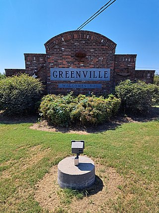
Greenville is the ninth-most populous city in the U.S. state of Mississippi, and the largest city by population in the Mississippi Delta region. It is the county seat of Washington County. The population was 29,670 at the 2020 Census.

Thomas Carmichael Hindman Jr. was an American lawyer, politician, and a senior officer of the Confederate States Army during the American Civil War. Born in Knoxville, Tennessee, he later moved to Mississippi and became involved in politics. He served in the Mexican–American War from 1846 to 1848. Hindman practiced law and in 1853 was elected to the Mississippi House of Representatives. After his term expired in 1854, he moved to Helena, Arkansas where there were more opportunities for his political ambitions. Hindman opposed the Know-Nothing party and Arkansas's ruling Conway-Johnson dynasty. He was elected to the United States House of Representatives in 1858, and supported slavery and secession. He was assassinated during the Reconstruction era.

The Great Mississippi Flood of 1927 was the most destructive river flood in the history of the United States, with 27,000 square miles (70,000 km2) inundated in depths of up to 30 feet (9 m) over the course of several months in early 1927. The period cost of the damage has been estimated to be between $246 million and $1 billion, which ranges from $4.2–$17.3 billion in 2023 dollars.
The Battle of Helena was fought on July 4, 1863, near Helena, Arkansas, during the American Civil War. Union troops captured the city in July 1862, and had been using it as a base of operations. Over 7,500 Confederate troops led by Lieutenant General Theophilus Holmes attempted to capture Helena in hopes of relieving some of the pressure on the Confederate army besieged in Vicksburg, Mississippi. Helena was defended by about 4,100 Union troops led by Major General Benjamin Prentiss, manning one fort and four batteries of artillery.
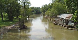
The St. Francis River is a tributary of the Mississippi River, about 426 miles (686 km) long, in southeastern Missouri and northeastern Arkansas in the United States. The river drains a mostly rural area and forms part of the Missouri-Arkansas state line along the western side of the Missouri Bootheel.

Helena–West Helena is the county seat of and the largest city within Phillips County, Arkansas, United States. The current city was consolidated, effective January 1, 2006, from the two Arkansas cities of Helena and West Helena. Helena is sited on lowlands between the Mississippi River and the eastern side of Crowley's Ridge. West Helena is located on the western side of Crowley's Ridge, a geographic anomaly in the typically flat Arkansas Delta. The Helena Bridge, one of Arkansas' four Mississippi River bridges, carries U.S. Route 49 across to Mississippi. The combined population of the two cities was 15,012 at the 2000 census and at the 2010 census, the official population was 12,282.

The Natchez–Vidalia Bridge are two twin cantilever bridges carrying U.S. Route 84, and 425 across the Mississippi River between Vidalia, Louisiana and Natchez, Mississippi. It is the tallest bridge in Mississippi.

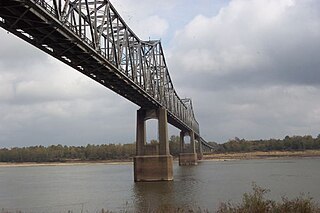
The Greenville Bridge, or the Jesse Brent Memorial Bridge, is a cable-stayed bridge over the Mississippi River, in the United States, carrying US 82 and US 278 between Refuge, Mississippi, and Shives, Arkansas. When it opened in 2010, it was the fourth-longest cable-stayed bridge in North America.
The Benjamin G. Humphreys Bridge was a two-lane cantilevered truss bridge carrying U.S. Route 82/U.S. Route 278 across the Mississippi River between Lake Village, Arkansas and Greenville, Mississippi. It was the first bridge to connect the two towns. The bridge was named for Benjamin G. Humphreys II, a former United States Congressman from Greenville.

The Memphis & Arkansas Bridge, also known as the Memphis–Arkansas Bridge or inaccurately as the Memphis–Arkansas Memorial Bridge, is a cantilevered through truss bridge carrying Interstate 55 across the Mississippi River between West Memphis, Arkansas and Memphis, Tennessee. Memphians refer to this bridge as the "Old Bridge" to distinguish it from the "New Bridge", or Hernando de Soto Bridge, upstream.

The Frisco Bridge, previously known as the Memphis Bridge, is a cantilevered through truss bridge carrying a rail line across the Mississippi River between West Memphis, Arkansas, and Memphis, Tennessee.

The Harahan Bridge is a cantilevered through truss bridge that carries two rail lines and a pedestrian bridge across the Mississippi River between West Memphis, Arkansas, and Memphis, Tennessee. The bridge is owned and operated by Union Pacific Railroad and is the second longest pedestrian/bicycle bridge in the United States. It was built with roadways cantilevered off the sides of the main structure for vehicles. These roadways are owned by the cities of Memphis, Tennessee, and Crittenden County, Arkansas, and were used from 1917–1949, until the Memphis & Arkansas Bridge opened 400 feet (120 m) south of the Harahan. The bridge was named in honor of railroad executive James Theodore Harahan, former president of the Illinois Central Railroad, who was killed in a railroad accident during the construction of the bridge. In February 2011, Union Pacific Railroad officials agreed to the idea of converting the 1917 roadways into a bicycle-pedestrian walkway across the river. In June 2012, Memphis was awarded a $14.9 million federal grant to build the walkway. The overall project was expected to cost $30 million, of which about $11 million was used for the Harahan Bridge portion. Construction was completed in 2016.

The Hernando de Soto Bridge is a tied-arch bridge carrying Interstate 40 across the Mississippi River between West Memphis, Arkansas, and Memphis, Tennessee. The design is a continuous cantilevered cable-stayed steel through arch, with bedstead endposts. Memphians also call the bridge the "New Bridge", as it is newer than the Memphis & Arkansas Bridge downstream, and the "M Bridge", due to its distinctive shape. It is of similar construction to the Sherman Minton Bridge between Louisville, Kentucky, and New Albany, Indiana.

State Road 2 is a former east–west state highway in the Arkansas Timberlands and Lower Arkansas Delta. The route was approximately 195 miles (314 km), and ran from US Route 67 (US 67) in Texarkana east to cross the Mississippi River near Lake Village, continuing as Mississippi Highway 10. On July 1, 1931, the route was entirely replaced by US Highway 82 (US 82) by the American Association of State Highway Officials (AASHTO). The route was maintained by the Arkansas Highway Department (AHD), now known as the Arkansas Department of Transportation (ArDOT).

Mississippi was the second southern state to declare its secession from the United States, doing so on January 9, 1861. It joined with six other southern states to form the Confederacy on February 4, 1861. Mississippi's location along the lengthy Mississippi River made it strategically important to both the Union and the Confederacy; dozens of battles were fought in the state as armies repeatedly clashed near key towns and transportation nodes.

Benjamin Grubb Humphreys II was an American lawyer and politician who served ten consecutive terms as a U.S. Representative from Mississippi from 1903 to 1923.
The Little Rock Campaign, officially known as Advance of the Union forces upon Little Rock, Arkansas, was a campaign conducted by the Union Army in Arkansas during the American Civil War. The strategic offensive was designed to capture Little Rock.


