Liberty, Mississippi | |
---|---|
Coordinates: 31°9′39″N90°48′14″W / 31.16083°N 90.80389°W Coordinates: 31°9′39″N90°48′14″W / 31.16083°N 90.80389°W | |
Country | United States |
State | Mississippi |
County | Amite |
Government | |
• Mayor | Pat Talbert |
Area | |
• Total | 2.06 sq mi (5.34 km2) |
• Land | 2.06 sq mi (5.34 km2) |
• Water | 0.00 sq mi (0.00 km2) |
Elevation | 338 ft (103 m) |
Population (2020) | |
• Total | 560 |
• Density | 271.71/sq mi (104.90/km2) |
Time zone | UTC-6 (Central (CST)) |
• Summer (DST) | UTC-5 (CDT) |
ZIP code | 39645 |
Area code | 601 |
FIPS code | 28-40640 |
GNIS feature ID | 0672435 |
Website | www |
Liberty is a town in Amite County, Mississippi. It is part of the McComb, Mississippi micropolitan statistical area. It is the county seat of Amite County. [2]
The town can be accessed via I-55, then west on Mississippi Highway 24. McGehee Air Park is located about a mile west of town.
Liberty celebrates its Heritage Days Festival during the first weekend of each May.
Air Cruisers manufacturing plant is located in Liberty. Owned by Zodiac Aerospace, the plant produces evacuation slides, life rafts, and life vests for the aviation industry.
Eleven sites in or near Liberty are listed on the National Register of Historic Places.
This section needs additional citations for verification .(November 2022) |
Liberty was incorporated on February 24, 1809. The Amite County Courthouse in Liberty is the oldest in Mississippi. Erected in 1839, the courthouse was enlarged and modernized in 1936. [4] It is listed on the National Register of Historic Places.
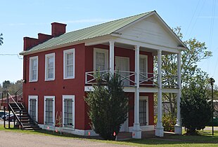
The Amite Female Seminary (also known as the 'Little Red Schoolhouse'), built in 1853, was a girls finishing school located in Liberty. During the American Civil War, in the spring of 1863, Federal troops under the command of Colonel Benjamin Grierson, a former music teacher, burned the school, but spared the school's music building. The Federal commander permitted musical instruments to be removed, and was prepared to give the order to torch the building, when he recognized the music school's director, Rev. Milton Shirk, as a former classmate from New York. The two-story, two-room music building survives to this day on Mississippi Highway 569, and is listed on the National Register of Historic Places. [5]
Gail Borden, who developed a process in the early 1850s for condensing milk and founded the New York Condensed Milk Company (later known as Borden Inc., lived in Liberty from 1822 to 1829.[ citation needed ]
Between 1904 and 1921, a branch of the Liberty–White Railroad, a narrow-gauge logging rail line serving the White Lumber Company, ran between McComb, Mississippi and Liberty. [6]
During the Civil Rights Movement, in September 1961, Herbert Lee, an African-American dairy farmer and member of NAACP, was murdered in Liberty at the Westbrook Cotton Gin by E.H. Hurst, a white state legislator. Lee had attended voter registration classes and volunteered to try to register to vote, Witnesses to the killing were intimidated by armed white men in the courtroom to support Hurst's claim of self-defense, and he was released without charges. Louis Allen, a married African-American landowner with a logging business, reported the truth about the crime to federal officials while seeking protection for testimony. He did not get protection. He suffered economic blackmail, arrests and harassment, and was killed in January 1964.[ citation needed ]
Liberty was the location of the fourth-wettest tropical cyclone in Mississippi in 2001; Tropical Storm Allison dropped 18.95 inches (481 mm) of precipitation.
Liberty, Texas is thought to have been named after this town, as numerous families from Amite County moved west in the 1820s to settle in the Atascosito district north-east of Houston. [7]
According to the United States Census Bureau, the town covers an area of 2.0 square miles (5.3 km2), of which 0.00077 square miles (0.002 km2), or 0.03%, is water. [8]
Historical population | |||
---|---|---|---|
Census | Pop. | %± | |
1900 | 392 | — | |
1910 | 556 | 41.8% | |
1920 | 515 | −7.4% | |
1930 | 551 | 7.0% | |
1940 | 665 | 20.7% | |
1950 | 683 | 2.7% | |
1960 | 642 | −6.0% | |
1970 | 612 | −4.7% | |
1980 | 669 | 9.3% | |
1990 | 624 | −6.7% | |
2000 | 633 | 1.4% | |
2010 | 728 | 15.0% | |
2020 | 560 | −23.1% | |
U.S. Decennial Census [9] |
Race | Num. | Perc. |
---|---|---|
White (non-Hispanic) | 403 | 71.96% |
Black or African American (non-Hispanic) | 122 | 21.79% |
Other/Mixed | 21 | 3.75% |
Hispanic or Latino | 14 | 2.5% |
As of the 2020 United States census, there were 560 people, 282 households, and 184 families residing in the town.
The town of Liberty is served by the Amite County School District. Liberty is also the home of Amite School Center, a K-12 education institution that is a member of the Mississippi Association of Independent Schools. The town manages a state property named the Ethel Stratton Vance Natural Area, just west of town, which is often used for educational purposes and is home to sports fields, camping areas, a large equestrian center, and over 200 acres of biologically diverse ravines, beaver impoundments, and bottomland hardwood forest along the West Fork Amite River. [11]
Wilkinson County is a county located in the southwest corner of the U.S. state of Mississippi. As of 2020, its population was 8,587. Its county seat is Woodville. Bordered by the Mississippi River on the west, the county is named for James Wilkinson, a Revolutionary War military leader and first governor of the Louisiana Territory after its acquisition by the United States in 1803.
Quitman County is a county located in the U.S. state of Mississippi. As of the 2020 census, the population was 6,176, making it the third-least populous county in Mississippi. Its county seat is Marks. The county is named after John A. Quitman, Governor of Mississippi from 1835 to 1836 and from 1850 to 1851.
Holmes County is a county in the U.S. state of Mississippi; its western border is formed by the Yazoo River and the eastern border by the Big Black River. The western part of the county is within the Yazoo-Mississippi Delta. As of the 2020 census, the population was 17,000. Its county seat is Lexington. The county is named in honor of David Holmes, territorial governor and the first governor of the state of Mississippi and later United States Senator for Mississippi. Holmes County native, Edmond Favor Noel, was an attorney and state politician, elected as governor of Mississippi, serving from 1908 to 1912.
Franklin County is a county located in the U.S. state of Mississippi. As of the 2020 census, the population was 7,675. Its county seat is Meadville. The county was formed on December 21, 1809, from portions of Adams County and named for Founding Father Benjamin Franklin. It is bisected by the Homochitto River, which runs diagonally through the county from northeast to southwest.
Claiborne County is a county located in the U.S. state of Mississippi. As of the 2020 census, the population was 9,135. Its county seat is Port Gibson. The county is named after William Claiborne, the second governor of the Mississippi Territory.
Amite County is a county located in the state of Mississippi on its southern border with Louisiana. As of the 2020 census, the population was 12,720. Its county seat is Liberty. The county is named after the Amite River, which runs through the county.
Amite City is a town in Tangipahoa Parish, of which it is the parish seat, in southeastern Louisiana, United States. The population was 4,141 at the 2010 census. It is part of the Hammond Micropolitan Statistical Area.
Gloster is a town in central Amite County, Mississippi, United States. The population was 897 at the 2020 census.
Mound Bayou is a city in Bolivar County, Mississippi, United States. The population was 1,533 at the 2010 census, down from 2,102 in 2000. It was founded as an independent black community in 1887 by former slaves led by Isaiah Montgomery.
Lexington is a city in and the county seat of Holmes County, Mississippi, United States. The county was organized in 1833 and the city in 1836. The population was 1,731 at the 2010 census, down from 2,025 at the 2000 census. The estimated population in 2018 was 1,496. It has declined from its high of 3,198 in 1950 due to the expansion of industrial-scale agriculture.
Yazoo City is a U.S. city in Yazoo County, Mississippi. It was named after the Yazoo River, which, in turn was named by the French explorer Robert La Salle in 1682 as "Rivière des Yazous" in reference to the Yazoo tribe living near the river's mouth. It is the county seat of Yazoo County and the principal city of the Yazoo City Micropolitan Statistical Area, which is part of the larger Jackson–Yazoo City Combined Statistical Area. According to the 2010 census, the population was 11,403. The most important industry in 2021 is a group of federal prisons.
Centreville is a town in Amite and Wilkinson counties, Mississippi, United States. It is part of the McComb, Mississippi micropolitan statistical area. Its population was 1,258 in 2020.
Crosby is a town in Amite and Wilkinson counties, Mississippi, United States. It is part of the McComb, Mississippi micropolitan statistical area. Its population was 242 at the 2020 census.
The McComb Micropolitan Statistical Area is a micropolitan area in southwestern Mississippi that includes Amite, and Pike Counties, which had a combined population of 53,124 as of the 2020 census.
The Amite County School District (ACSD) is a public school district based in Liberty, Mississippi (USA). The district's boundaries parallel that of Amite County. In addition to Liberty, the district includes Gloster and the Amite County portions of Centreville and Crosby.
Eugene Hunter Hurst Jr. was an American, dairy farmer, and politician from Amite County, Mississippi. Elected as a Democrat to the Mississippi House of Representatives for a single term in 1959, Hurst supported segregation and opposed the civil rights movement, which had expanded into Amite County by the early 1960s.
Mississippi is a state in the Southeastern region of the United States, bordered to the north by Tennessee; to the east by Alabama; to the south by the Gulf of Mexico; to the southwest by Louisiana; and to the northwest by Arkansas. Mississippi's western boundary is largely defined by the Mississippi River. Mississippi is the 32nd largest and 35th-most populous of the 50 U.S. states and has the lowest per-capita income in the United States. Jackson is both the state's capital and largest city. Greater Jackson is the state's most populous metropolitan area, with a population of 591,978 in 2020.
Louis Allen was an African-American businessman in Liberty, Mississippi, who was shot and killed on his land during the civil rights era. He had previously tried to register to vote and had allegedly talked to federal officials after witnessing the 1961 murder of Herbert Lee, an NAACP member, by E. H. Hurst, a white state legislator. Civil rights activists had come to Liberty that summer to organize for voter registration, as no African-American had been allowed to vote since the state's disenfranchising constitution was passed in 1890.
Mississippi Highway 569 is a state highway in southwestern Mississippi. The route starts at the Mississippi–Louisiana state line, and it travels northeastward from that point. It intersects MS 48 southwest of Liberty, and MS 569 becomes concurrent with it. Inside Liberty, MS 569 is also concurrent with MS 24 briefly before travelling northeastward out of the city. It continues through Amite County and it ends at U.S. Route 98 in extreme southwestern Lincoln County.
Herbert T. Lee was an American civil rights activist in Mississippi remembered as a proponent of voting rights for African Americans in that state, who had been disenfranchised since 1890. He was a charter member of the National Association for the Advancement of Colored People in Amite County and sought to enfranchise African-Americans by encouraging voter registration.