Charleston, Mississippi

Last updated

Charleston, Mississippi
WelcomeToCharlestonSignHwy32.jpg
Flag of Charleston, Mississippi.svg
Tallahatchie County Mississippi Incorporated and Unincorporated areas Charleston Highlighted.svg
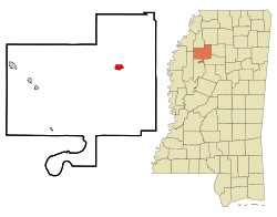
Location of Charleston, Mississippi
Usa edcp location map.svg
Red pog.svg
Charleston, Mississippi
Location in the United States
Coordinates: 34°00′15″N90°03′19″W / 34.00417°N 90.05528°W / 34.00417; -90.05528
Country United States
State Mississippi
County Tallahatchie
Area
[1]
  Total
1.36 sq mi (3.52 km2)
  Land1.35 sq mi (3.51 km2)
  Water0.00 sq mi (0.01 km2)
Elevation
[2]
213 ft (65 m)
Population
 (2020)
  Total
1,884
  Density1,390.41/sq mi (536.81/km2)
Time zone UTC-6 (Central (CST))
  Summer (DST) UTC-5 (CDT)
ZIP codes
38921, 38958
Area code 662
FIPS code 28-12900
GNIS feature ID2404031 [2]

Charleston is a city in north central Mississippi and one of the two county seats of Tallahatchie County, which is located on both sides of the Tallahatchie River. This city is located east of the river and its population was 2,193 at the 2010 census.

Contents

History

The original county seat, Old Tillatoba, was discovered to have a defective land title, so the seat was removed to Charleston in 1837. [3]

The Charleston Female school, established in 1852, flourished for several years. The Tallahatchie Herald, a Democratic weekly newspaper, was established in 1892. In 1901, the Charleston Bank was established. By the early 1900s, Charleston had a brick courthouse and jail, three churches, schools, a Masonic hall, an Odd Fellows lodge, and two cotton gins. Its leading agricultural staple was cotton. The population in 1906 was 800. [3]

In 1931, a magnitude 4.6 earthquake occurred in Charleston, the most powerful earthquake recorded in Mississippi. [4]

Geography

According to the United States Census Bureau, the city has a total area of 1.4 square miles (3.6 km2), of which 1.4 square miles (3.6 km2) is land and 0.73% is water. It is also situated on the northern end of the concurrency of Mississippi Highways 32 and 35.

The city's official nickname is "Gateway to the Delta".

Demographics

Historical population
CensusPop.Note
1880 368
1890 41212.0%
1900 48016.5%
1910 1,834282.1%
1920 3,00764.0%
1930 2,014−33.0%
1940 2,1004.3%
1950 2,62925.2%
1960 2,528−3.8%
1970 2,82111.6%
1980 2,8782.0%
1990 2,328−19.1%
2000 2,198−5.6%
2010 2,193−0.2%
2020 1,884−14.1%
U.S. Decennial Census [5]

2020 census

Charleston Racial Composition [6]
RaceNum.Perc.
White 42522.56%
Black or African American 1,41375.0%
Asian 40.21%
Other/Mixed 261.38%
Hispanic or Latino 160.85%

As of the 2020 United States Census, there were 1,884 people, 792 households, and 514 families residing in the city.

2000 census

As of the census [7] of 2000, there were 2,198 people, 848 households, and 569 families residing in the city. The population density was 1,612.7 inhabitants per square mile (622.7/km2). There were 933 housing units at an average density of 684.6 per square mile (264.3/km2). The racial makeup of the city was 39.26% White, 59.69% African American, 0.36% Asian, 0.05% from other races, and 0.64% from two or more races. Hispanic or Latino of any race were 1.55% of the population.

There were 848 households, out of which 29.5% had children under the age of 18 living with them, 33.5% were married couples living together, 28.4% had a female householder with no husband present, and 32.8% were non-families. 31.0% of all households were made up of individuals, and 15.8% had someone living alone who was 65 years of age or older. The average household size was 2.51 and the average family size was 3.14.

In the city, the population was spread out, with 27.4% under the age of 18, 9.1% from 18 to 24, 25.2% from 25 to 44, 20.1% from 45 to 64, and 18.2% who were 65 years of age or older. The median age was 36 years. For every 100 females, there were 79.3 males. For every 100 females age 18 and over, there were 72.4 males.

The median income for a household in the city was $18,208, and the median income for a family was $24,750. Males had a median income of $26,500 versus $16,406 for females. The per capita income for the city was $10,835. About 30.7% of families and 34.4% of the population were below the poverty line, including 49.4% of those under age 18 and 29.1% of those age 65 or over.

Education

The City of Charleston is served by the East Tallahatchie School District. Before 1970, a dual system of schools, one for black students and another for whites was maintained. In 1970, the federal courts mandated in Alexander v. Holmes County Board of Education that the schools be integrated, and the school district adopted a plan by which classrooms remained segregated, but during the course of the school day entire classes of children and teachers were bused between East Tallahatchie High School and Allen Carver High School. The black students of Allen Carver protested, and the sheriff arrested 125 of them and sent them to the state penitentiary at Parchman. After intervention by the federal Community Relations Service, the students were allowed to reenter school and makeup missed exams. The classrooms were integrated, new elections were held for student government, and some black cheerleaders were added. [8] [9]

Charleston High School held its first racially integrated prom in April 2008. [10] This event was the subject of the 2008 HBO documentary Prom Night in Mississippi . The documentary focused on Charleston High School and the efforts to have a mixed prom instead of the traditional racially segregated proms.

Strider Academy, near the city, closed in 2018.

Coahoma Community College is the designated community college. [11]

Notable people

Related Research Articles

<span class="mw-page-title-main">Tunica County, Mississippi</span> County in Mississippi, United States

Tunica County is a county located in the U.S. state of Mississippi. As of the 2020 census, the population was 9,782. Its county seat is Tunica. The county is named for the Tunica Native Americans. Most migrated to central Louisiana during the colonial period.

<span class="mw-page-title-main">Tippah County, Mississippi</span> County in Mississippi, United States

Tippah County is a county located on the northern border of the U.S. state of Mississippi. As of the 2020 census, the population was 21,815. Its county seat is Ripley. The name "Tippah" is derived from a Chickasaw language word meaning "cut off." It was taken from the creek of the same name that flows across much of the original county from northeast to southwest before emptying into the Tallahatchie River. The creek probably was so named because it, and the ridges on either side, "cut off" the western part of the region from the eastern portion.

<span class="mw-page-title-main">Tallahatchie County, Mississippi</span> County in Mississippi, United States

Tallahatchie County is a county in the U.S. state of Mississippi. At the 2020 census, the population was 12,715. Its county seats are Charleston and Sumner.

<span class="mw-page-title-main">Quitman County, Mississippi</span> County in Mississippi, United States

Quitman County is a county located in the U.S. state of Mississippi. As of the 2020 census, the population was 6,176, making it the third-least populous county in Mississippi. Its county seat is Marks. The county is named after John A. Quitman, Governor of Mississippi from 1835 to 1836 and from 1850 to 1851.

<span class="mw-page-title-main">Panola County, Mississippi</span> County in Mississippi, United States

Panola County is a county located in the U.S. state of Mississippi. As of the 2020 census, the population was 33,208. Its county seats are Sardis and Batesville. The county is located just east of the Mississippi Delta in the northern part of the state. It is bisected by the Tallahatchie River flowing to the southwest; travel difficulties because of the river resulted in two county seats being established.

<span class="mw-page-title-main">Leflore County, Mississippi</span> County in Mississippi, United States

Leflore County is a county located in the U.S. state of Mississippi. As of the 2020 census, the population was 28,339. The county seat is Greenwood. The county is named for Choctaw leader Greenwood LeFlore, who signed a treaty to cede his people's land to the United States in exchange for land in Indian Territory. LeFlore stayed in Mississippi, settling on land reserved for him in Tallahatchie County.

<span class="mw-page-title-main">Coahoma County, Mississippi</span> County in Mississippi, United States

Coahoma County is a county located in the U.S. state of Mississippi. As of the 2020 census, the population was 21,390. Its county seat is Clarksdale.

<span class="mw-page-title-main">Bolivar County, Mississippi</span> County in Mississippi, United States

Bolivar County is a county located on the western border of the U.S. state of Mississippi. As of the 2020 census, the population was 30,985. Its county seats are Rosedale and Cleveland. The county is named in honor of Simón Bolívar, early 19th-century leader of the liberation of several South American territories from Spain.

<span class="mw-page-title-main">Coahoma, Mississippi</span> Town in Mississippi, United States

Coahoma is a town in Coahoma County, Mississippi, United States. Per the 2020 census, the population was 229.

<span class="mw-page-title-main">Sardis, Mississippi</span> Town in Mississippi, United States

Sardis is a town in Panola County, Mississippi, United States. As of the 2020 census, the town population was 1,748. Sardis is one of two county seats for Panola County; the other is Batesville, on the south side of the Tallahatchie River.

<span class="mw-page-title-main">Ecru, Mississippi</span> Town in Mississippi, United States

Ecru is a town in Pontotoc County, Mississippi. The population was 895 at the 2010 census. Ecru is home to the largest upholstered furniture plant in the world which manufactures Ashley Furniture.

<span class="mw-page-title-main">Glendora, Mississippi</span> Village in Mississippi, United States

Glendora is a village in Tallahatchie County, Mississippi. The population was 285 at the 2000 census.

<span class="mw-page-title-main">Sumner, Mississippi</span> Town in Mississippi, United States

Sumner is a town in Tallahatchie County, Mississippi. The population was 407 at the 2000 census. Sumner is one of the two county seats of Tallahatchie County. It is located on the west side of the county and the Tallahatchie River, which runs through the county north–south. The other county seat is Charleston, located east of the river. Charleston was the first county seat, as settlement came from the east, and it is the larger of the two towns.

<span class="mw-page-title-main">Tutwiler, Mississippi</span> Town in Mississippi, United States

Tutwiler is a town in Tallahatchie County, Mississippi, United States. The population at the 2020 census was 2,476.

<span class="mw-page-title-main">Webb, Mississippi</span> Town in Mississippi, United States

Webb is a town in Tallahatchie County, Mississippi. The population was 565 at the 2010 census.

<span class="mw-page-title-main">New Albany, Mississippi</span> City in Mississippi, United States

New Albany is a city in and the county seat of Union County, Mississippi, United States. According to the 2020 United States Census, the population was 7,626.

<span class="mw-page-title-main">Charleston, Missouri</span> City in Missouri, United States

Charleston is a city in Mississippi County, Missouri, United States. The population was 5,056 at the 2020 census, down from 5,947 in 2010. It is the county seat of Mississippi County and is home to the Southeast Correctional Center.

<span class="mw-page-title-main">Jonestown, Coahoma County, Mississippi</span> Town in Mississippi, United States

Jonestown is a town in Coahoma County, Mississippi, United States. Per the 2020 census, the population was 962.

<span class="mw-page-title-main">Lula, Mississippi</span> Town in Mississippi, United States

Lula is a town in Coahoma County, Mississippi, United States. Per the 2020 census, the population was 204.

<span class="mw-page-title-main">Lyon, Mississippi</span> Town in Mississippi, United States

Lyon is a town in Coahoma County, Mississippi, United States. Per the 2020 census, the population was 296.

References

  1. "2020 U.S. Gazetteer Files". United States Census Bureau. Retrieved July 24, 2022.
  2. 1 2 U.S. Geological Survey Geographic Names Information System: Charleston, Mississippi
  3. 1 2 Rowland, Dunbar (1907). Mississippi: Comprising Sketches of Counties, Towns, Events, Institutions, and Persons, Arranged in Cyclopedic Form. Vol. 1. Southern Historical Publishing Association. pp.  395, 396.
  4. "US Geological Survey". Earthquake.usgs.gov. 1993. Retrieved October 12, 2012.
  5. "Census of Population and Housing". Census.gov. Retrieved June 4, 2015.
  6. "Explore Census Data". data.census.gov. Retrieved December 7, 2021.
  7. "U.S. Census website". United States Census Bureau . Retrieved January 31, 2008.
  8. Bolton, Charles C (1980). The Hardest Deal of All: The Battle Over School Integration in Mississippi 1870-1980 . University Press of Mississippi. p. 186.
  9. Community Relations Service (1972). "Activities Relating to the Desegregation of Public Schools: Charleston, Mississippi" (PDF). pp. 19–20. Archived (PDF) from the original on April 25, 2015. Retrieved January 13, 2019.
  10. Mississippi School Holds First Interracial Prom. The Bryant Park Project . National Public Radio. 2008-06-11.
  11. "Student Residency" (Archive). Coahoma Community College. Retrieved on July 8, 2017. "Out-of-District Resident: A student who does not live within Bolivar, Coahoma, Quitman, Tallahatchie, and Tunica Counties but does live in some other county in Mississippi."
  12. Binder, David (September 10, 1995). "Jamie Whitten, Who Served 53 Years in House, Dies at 85". The New York Times.