Vance, Mississippi

Last updated

Vance, Mississippi
VanceMSHighwaySign.jpg
USA Mississippi location map.svg
Red pog.svg
Vance, Mississippi
Usa edcp location map.svg
Red pog.svg
Vance, Mississippi
Coordinates: 34°04′22″N90°21′03″W / 34.07278°N 90.35083°W / 34.07278; -90.35083
Country United States
State Mississippi
Counties Quitman, Tallahatchie
Elevation
154 ft (47 m)
Time zone UTC-6 (Central (CST))
  Summer (DST) UTC-5 (CDT)
ZIP code
38964
Area code 662
GNIS feature ID679184 [1]

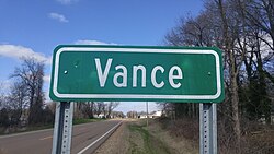
Vance is an unincorporated community in Quitman and Tallahatchie counties, Mississippi. [1] Vance is located on Mississippi Highway 3 northeast of Tutwiler. Vance has a post office with ZIP code 38964. [2]

Contents

Education

The Tallatachie County section is in the West Tallahatchie School District. [3] R. H. Bearden School and West Tallahatchie High School are the local schools.

The Quitman County section is in the Quitman County School District.

Coahoma Community College is the designated community college for Tallahatchie and Quitman counties. [4]

Notable people

Blues musician Sunnyland Slim was born on a farm near Vance.

Related Research Articles

<span class="mw-page-title-main">Tallahatchie County, Mississippi</span> County in Mississippi, United States

Tallahatchie County is a county in the U.S. state of Mississippi. At the 2020 census, the population was 12,715. Its county seats are Charleston and Sumner.

<span class="mw-page-title-main">Quitman County, Mississippi</span> County in Mississippi, United States

Quitman County is a county located in the U.S. state of Mississippi. As of the 2020 census, the population was 6,176, making it the third-least populous county in Mississippi. Its county seat is Marks. The county is named after John A. Quitman, Governor of Mississippi from 1835 to 1836 and from 1850 to 1851.

<span class="mw-page-title-main">Panola County, Mississippi</span> County in Mississippi, United States

Panola County is a county located in the U.S. state of Mississippi. As of the 2020 census, the population was 33,208. Its county seats are Sardis and Batesville. The county is located just east of the Mississippi Delta in the northern part of the state. It is bisected by the Tallahatchie River flowing to the southwest; travel difficulties because of the river resulted in two county seats being established.

<span class="mw-page-title-main">Coahoma County, Mississippi</span> County in Mississippi, United States

Coahoma County is a county located in the U.S. state of Mississippi. As of the 2020 census, the population was 21,390. Its county seat is Clarksdale.

<span class="mw-page-title-main">Charleston, Mississippi</span> City in Mississippi, United States

Charleston is a city in north central Mississippi and one of the two county seats of Tallahatchie County, which is located on both sides of the Tallahatchie River. This city is located east of the river and its population was 2,193 at the 2010 census.

<span class="mw-page-title-main">Glendora, Mississippi</span> Village in Mississippi, United States

Glendora is a village in Tallahatchie County, Mississippi. The population was 285 at the 2000 census.

<span class="mw-page-title-main">Sumner, Mississippi</span> Town in Mississippi, United States

Sumner is a town in Tallahatchie County, Mississippi. The population was 407 at the 2000 census. Sumner is one of the two county seats of Tallahatchie County. It is located on the west side of the county and the Tallahatchie River, which runs through the county north-south. The other county seat is Charleston, located east of the river. Charleston was the first county seat, as settlement came from the east, and it is the larger of the two towns.

<span class="mw-page-title-main">Cleveland, Mississippi</span> City in Mississippi, United States

Cleveland is a city in Bolivar County, Mississippi, United States. The population was 11,199 as of the 2020 United States Census.

<span class="mw-page-title-main">Minter City, Mississippi</span> Unincorporated community in Mississippi, United States

Minter City is an unincorporated community in Leflore County and Tallahatchie County, Mississippi. It is part of the Greenwood, Mississippi micropolitan area, and is within the Mississippi Delta.

<span class="mw-page-title-main">Mississippi Highway 6</span> Highway in Mississippi

Mississippi Highway 6 (MS 6) runs east–west from MS 161 in Lyon, east to MS 25 near Amory. It travels approximately 139 miles (224 km), serving Coahoma, Quitman, Panola, Lafayette, Pontotoc, Lee, and Monroe Counties. West of Tupelo, it is concurrent with US 278. Points of interest along the route include the University of Mississippi, Trace State Park, Natchez Trace Parkway, the Elvis Presley Birthplace, and Tombigbee State Park.

<span class="mw-page-title-main">Money, Mississippi</span> Unincorporated community in Mississippi, United States

Money is an unincorporated community near Greenwood in Leflore County, Mississippi, United States, in the Mississippi Delta. It has fewer than 100 residents, down from 400 in the early 1950s when a cotton mill operated there. Money is located on a railroad line along the Tallahatchie River, a tributary of the Yazoo River in the eastern part of the Mississippi Delta. The community has ZIP code 38945 in the Greenwood, Mississippi micropolitan area.

<span class="mw-page-title-main">Mississippi Highway 3</span> State Highway in Mississippi

Mississippi Highway 3 is a north–south Mississippi state highway, located entirely within the Mississippi Delta region, running from Redwood to Lake Cormorant, both at an intersection with U.S. Route 61. For much of its duration, MS 3 is overlapped (concurrent) with U.S. Route 49W. It travels approximately 192 miles (309 km), serving DeSoto, Tunica, Tate, Panola, Quitman, Tallahatchie, Sunflower, Humphreys, Yazoo, and Warren counties.

<span class="mw-page-title-main">Philipp, Mississippi</span> Unincorporated community in Mississippi, United States

Philipp is an unincorporated community in southern Tallahatchie County, Mississippi, United States, along Mississippi Highway 8. Philipp is 6 miles (9.7 km) east of Minter City and 14 miles (23 km) west of Holcomb. Although Philipp is an unincorporated community, it has a post office with a ZIP code of 38950.

The West Tallahatchie School District (WTSD) is a public school district with its headquarters in the Charles M. George Facility for Educational Services in unincorporated Tallahatchie County, Mississippi (USA), adjacent to Sumner.

Coahoma Community College (CCC) is a public historically black community college in Coahoma County, Mississippi. The college was founded in 1949 and is accredited by the Southern Association of Colleges and Schools Commission on Colleges. It offers associate degree and certificate programs in more than 70 areas of focus.

<span class="mw-page-title-main">Tippo, Mississippi</span> Unincorporated community in Mississippi, United States

Tippo is an unincorporated community located in Tallahatchie County, Mississippi, United States, located approximately 10 miles (16 km) from Swan Lake; 11 miles (18 km) northeast of Glendora; and approximately 14 miles (23 km) from Charleston. Tippo is located at the intersection of Tippo and Sharkey roads.

<span class="mw-page-title-main">Brazil, Mississippi</span> Unincorporated community in Mississippi, United States

Brazil is an unincorporated community in Tallahatchie County, Mississippi. Brazil is on Mississippi Highway 321 approximately 8 miles (13 km) north of Webb and 12 miles (19 km) south of Lambert.

<span class="mw-page-title-main">Sherard, Mississippi</span> Unincorporated community in Mississippi, United States

Sherard is an unincorporated community located in Coahoma County, Mississippi, United States. Sherard is located along Mississippi Highway 1, 6 miles (9.7 km) west of Clarksdale.

Stovall, also known as Prarieville, is an unincorporated community in Coahoma County, Mississippi, United States, along Mississippi Highway 1, 7 miles (11 km) north of Sherard and approximately 6 miles (9.7 km) south of Friars Point.

<span class="mw-page-title-main">Mississippi Highway 322</span> Highway in Mississippi

Mississippi Highway 322 is an east-west state highway connecting Sherard at MS 1 to Crowder at MS 35. Traveling through Coahoma, Quitman, Panola counties, it has a length of 43.9 miles (70.7 km) and connects Clarksdale, Hopson, Lambert, and Crowder.

References

  1. 1 2 U.S. Geological Survey Geographic Names Information System: Vance, Mississippi
  2. ZIP Code Lookup
  3. "About WTSD". West Tallahatchie School District . Retrieved May 20, 2021.
  4. "Student Residency" (Archive). Coahoma Community College. Retrieved on July 8, 2017. "Out-of-District Resident: A student who does not live within Bolivar, Coahoma, Quitman, Tallahatchie, and Tunica Counties but does live in some other county in Mississippi."