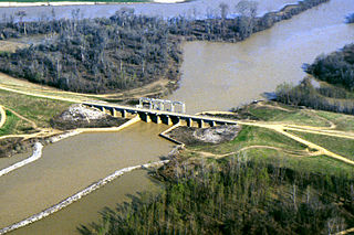
The Mississippi River is the primary river of the largest drainage basin in the United States. From its traditional source of Lake Itasca in northern Minnesota, it flows generally south for 2,340 miles (3,766 km) to the Mississippi River Delta in the Gulf of Mexico. With its many tributaries, the Mississippi's watershed drains all or parts of 32 U.S. states and two Canadian provinces between the Rocky and Appalachian mountains. The river either borders or passes through the states of Minnesota, Wisconsin, Iowa, Illinois, Missouri, Kentucky, Tennessee, Arkansas, Mississippi, and Louisiana. The main stem is entirely within the United States; the total drainage basin is 1,151,000 sq mi (2,980,000 km2), of which only about one percent is in Canada. The Mississippi ranks as the world's tenth-largest river by discharge flow, and the largest in North America.

The Quad Cities is a region of cities in the U.S. states of Iowa and Illinois: Davenport and Bettendorf in southeastern Iowa, and Rock Island, Moline and East Moline in northwestern Illinois. These cities are the center of the Quad Cities metropolitan area, a region within the Mississippi River Valley, which as of 2023 had a population estimate of 467,817 and a Combined Statistical Area (CSA) population of 474,019, making it the 90th-largest CSA in the nation.

The Great River Road is a collection of state and local roads that follow the course of the Mississippi River through ten states of the United States. They are Minnesota, Wisconsin, Iowa, Illinois, Missouri, Kentucky, Tennessee, Arkansas, Mississippi and Louisiana. It formerly extended north into Canada, serving the provinces of Ontario and Manitoba. The road is designated as both a National Scenic Byway and an All-American Road in several states along the route.

Quitman County is a county located in the U.S. state of Mississippi. As of the 2020 census, the population was 6,176, making it the third-least populous county in Mississippi. Its county seat is Marks. The county is named after John A. Quitman, Governor of Mississippi from 1835 to 1836 and from 1850 to 1851.

Jones County is in the southeastern portion of the U.S. state of Mississippi. As of the 2020 census, the population was 67,246. Its county seats are Laurel and Ellisville.

Biloxi is a city in Harrison County, Mississippi, United States. It lies on the Gulf Coast in southern Mississippi, bordering the city of Gulfport to its west. The adjacent cities are both designated as seats of Harrison County. The population of Biloxi was 49,449 at the 2020 census, making it the state's 4th most populous city. It is a principal city of the Gulfport–Biloxi metropolitan area, home to 416,259 residents in 2020. The area's first European settlers were French colonists.

Oxford is the 14th most populous city in Mississippi, United States, and the county seat of Lafayette County, 75 miles (121 km) southeast of Memphis. A college town, Oxford surrounds the University of Mississippi or "Ole Miss". Founded in 1837, the city is named for Oxford, England.

Hannibal is a city along the Mississippi River in Marion and Ralls counties in the U.S. state of Missouri. According to the 2020 U.S. Census, the population was 17,312, making it the largest city in Marion County. The bulk of the city is in Marion County, with a tiny sliver in the south extending into Ralls County.

West Florida was a region on the northern coast of the Gulf of Mexico that underwent several boundary and sovereignty changes during its history. As its name suggests, it was formed out of the western part of former Spanish Florida, along with lands taken from French Louisiana; Pensacola became West Florida's capital. The colony included about two thirds of what is now the Florida Panhandle, as well as parts of the modern U.S. states of Louisiana, Mississippi, and Alabama.

The Yazoo River is a river in the U.S. states of Louisiana and Mississippi. It is considered by some to mark the southern boundary of what is called the Mississippi Delta, a broad floodplain that was cultivated for cotton plantations before the American Civil War. It has continued to be devoted to large-scale agriculture.

The Gulf Intracoastal Waterway (GIWW) is the portion of the Intracoastal Waterway located along the Gulf Coast of the United States. It is a navigable inland waterway running approximately 1,300 mi (2,100 km) from Saint Marks, Florida, to Brownsville, Texas.

U.S. Route 90 or U.S. Highway 90 (US 90) is an east–west major United States highway in the Southern United States. Despite the "0" in its route number, US 90 never was a full coast-to-coast route. It generally travels near Interstate 10 (I-10) and passes through the southern states of Texas, Louisiana, Mississippi, Alabama, and Florida. US 90 also includes part of the DeSoto Trail between Tallahassee and Lake City, Florida.

The Trans-Mississippi and International Exposition was a world's fair held in Omaha, Nebraska, from June 1 to November 1, 1898. Its goal was to showcase the development of the entire West from the Mississippi River to the Pacific Coast. The Indian Congress was held concurrently. Over 2.6 million people came to Omaha to view the 4,062 exhibits during the five months of the Exposition. President William McKinley and William Jennings Bryan were among the dignitaries who attended at the invitation of Gurdon Wattles, the event's leader. A hundred thousand people assembled on the plaza to hear them speak. The Expo stretched over a 180-acre (0.73 km2) tract in North Omaha and featured a 2,000-foot-long (610 m) lagoon encircled by 21 classical buildings that featured fine and modern products from around the world.

U.S. Route 98 is an east–west United States Highway in the Southeastern United States that runs from western Mississippi to southern Florida. It was established in 1933 as a route between Pensacola and Apalachicola, Florida, and has since been extended westward into Mississippi and eastward across the Florida Peninsula. It runs along much of the Gulf Coast between Mobile, Alabama, and Crystal River, Florida, including extensive sections closely following the coast between Mobile and St. Marks, Florida. The highway's western terminus is with US 84 in Bude, Mississippi. Its eastern terminus is Palm Beach, Florida, at State Road A1A (SR A1A) near the Mar-a-Lago resort.

Route 32 is a highway in Missouri. Its eastern terminus is at the Mississippi River near Ste. Genevieve; its western terminus is at U.S. Route 54 in El Dorado Springs. It is currently one of the longest highways in the state. Most of the highway east of Lebanon is hilly and curvy, passing through a large part of the Missouri Ozarks.

The Memphis–Clarksdale-Forrest City Combined Statistical Area, TN–MS–AR (CSA) is the commercial and cultural hub of the Mid-South or Ark-Miss-Tenn. The census-defined combined statistical area covers eleven counties in three states, Tennessee, Mississippi, and Arkansas. As of 2020 census, the Memphis metropolitan area had a population of 1,389,905 The Forrest City, Arkansas Micropolitan area was added to the Memphis area in 2012 to form the Memphis–Forrest City Combined Statistical area. In 2023 the Clarksdale, Mississippi Micropolitan area was also added to form the new Memphis-Clarksdale-Forrest City Combined Statistical Area which as of 2023 had a population of roughly 1.4 million people according to census estimates.

U.S. Route 78 (US 78) is an east–west United States Numbered Highway that runs for 843.3 miles (1,357.2 km) from Cash, Arkansas, to Charleston, South Carolina. From Byhalia, Mississippi to Birmingham, Alabama, US 78 runs concurrently with Interstate 22 (I-22). The highway’s western terminus is at I-57/US 67 near Cash, and its eastern terminus is on Line Street, in Charleston. Prior to November 2023, before the western extension, the highway's former western terminus was at US 64/US 70/US 79 in Memphis, Tennessee.

Area code 662 is a telephone area code in the North American Numbering Plan (NANP) for the northern half of the U.S. state of Mississippi, including the six counties that are part of the Memphis metro area. It also includes the cities that are home to the state's two largest universities, Oxford and Starkville.

Samuel Ross Mason, also spelled Meason, was a Virginia militia captain, on the American western frontier, during the American Revolutionary War. After the war, he became the leader of the Mason Gang, a criminal gang of river pirates and highwaymen on the lower Ohio River and the Mississippi River in the late 18th and early 19th centuries. He was associated with outlaws around Red Banks, Cave-in-Rock, Stack Island, and the Natchez Trace.

Mississippi is a state in the Southeastern region of the United States. It borders Tennessee to the north, Alabama to the east, the Gulf of Mexico to the south, Louisiana to the southwest, and Arkansas to the northwest. Mississippi's western boundary is largely defined by the Mississippi River, or its historical course. Mississippi is the 32nd largest by area and 35th-most populous of the 50 U.S. states and has the lowest per-capita income. Jackson is both the state's capital and largest city. Greater Jackson is the state's most populous metropolitan area, with a population of 591,978 in 2020. Other major cities include Gulfport, Southaven, Hattiesburg, Biloxi, Olive Branch, Tupelo, Meridian, and Greenville.


