Greenville is a city in and the county seat of Washington County, Mississippi, United States. The population was 34,400 at the 2010 census. It is located in the area of historic cotton plantations and culture known as the Mississippi Delta.

Monrovia is the capital city of the West African country of Liberia. Founded in 1822, it is located on Cape Mesurado on the Atlantic coast and as of the 2008 census had 1,010,970 residents, home to 29% of Liberia’s total population. As the nation's primate city, Monrovia is the country's economic, financial and cultural center; its economy is primarily centered on its harbor and its role as the seat of Liberian government.

Montserrado County is a county in the northwestern portion of the West African nation of Liberia containing its national capital, Monrovia. One of 15 counties that comprise the first-level of administrative division in the nation, it has 17 sub political districts. As of the 2008 Census, it had a population of 1,118,241, making it the most populous county in Liberia. The area of the county measures 1,912.7 square kilometres (738.5 sq mi), the smallest in the country. Bensonville serves as the capital.

Grand Cape Mount is a county in the northwestern portion of the West African nation of Liberia. One of 15 counties that constitute the first-level of administrative division in the nation, it has five districts. Robertsport serves as the capital with the area of the county measuring 5,162 square kilometres (1,993 sq mi). As of the 2008 Census, it had a population of 129,817, making it the eighth most populous county in Liberia. The county is bordered by Gbarpolu County to the northeast and Bomi County to the southeast. The northern part of Grand Cape Mount borders the nation of Sierra Leone, while to the west lies the Atlantic Ocean.

Buchanan, also previously known as Grand Bassa on some maps, is the third largest city in Liberia, lying on Waterhouse Bay, part of the Atlantic Ocean. As of the 2008 census, Buchanan had a population of 34,270. Of this, 16,984 were male and 17,286 female.
Harper, situated on Cape Palmas, is the capital of Maryland County in Liberia. It is a coastal town situated between the Atlantic Ocean and the Hoffman River. Harper is Liberia's 11th largest town, with a population of 17,837.

Gbarnga is the capital city of Bong County, Liberia, lying north east of Monrovia. During the First Liberian Civil War, it was the base for Charles Taylor's National Patriotic Front of Liberia. Cuttington College, a private, Episcopal-affiliated institution, is located near the town. Its campus was once home to the Africana Museum, which was destroyed during the civil war.

Grand Gedeh is a county in the eastern portion of the West African nation of Liberia. One of 15 counties that constitute the first-level of administrative division in the nation, it has three districts. Zwedru serves as the capital with the area of the county. Measuring 10,484 square kilometres (4,048 sq mi), it is larger than 28 independent countries including Lebanon, Trinidad and Tobago, Cape Verde, Malta and Mauritius and the combined area of the US states of Delaware and Rhode Island. As of the 2008 Census, it had a population of 126,146, making it the ninth most populous county in Liberia. Grand Gedeh has lower tropical forests which has mid size hills composed of various valleys and water courses. These forests receive a very high rainfall ranging from 3,000 mm (120 in) to 4,100 mm (160 in) per year.

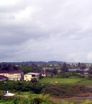
Sinoe is one of Liberia's 15 counties and it has 17 districts. Greenville is the county's capital. As of the 2008 Census, it had a population of 104,932, making it one of the least populous counties in Liberia. Sinoe has the third-largest area of all Liberia's counties; it has the second least-dense population after Gbarpolu County. The County was originally a colony in the name Mississippi-in-Africa, under auspices of a chapter of the American Colonization Society as it was created with slaves from Mississippi to Liberia.

River Gee is a county in the southern portion of Liberia. One of 15 counties that constitute the first-level of administrative division in the nation, it has six districts. Fish Town serves as the capital with the area of the county measuring 5,113 square kilometres (1,974 sq mi). As of the 2008 Census, it had a population of 66,789, making it the third-least populous county in Liberia. It was created in 2000.
Amos Claudius Sawyer was a Liberian politician and academic who served as interim president of Liberia from 22 November 1990 to 7 March 1994. He was voted into office by 35 leaders representing seven political parties and eleven interest groups.
Greenville District is one of 16 districts of Sinoe County, Liberia. As of 2008, the population was 16,434, making it the most populous district in the county.

Mississippi-in-Africa was a colony on the Pepper Coast founded in the 1830s by the Mississippi Colonization Society of the United States and settled by American free people of color, many of them former slaves. In the late 1840s, some 300 former slaves from Prospect Hill Plantation and other Isaac Ross properties in Jefferson County, Mississippi, were the largest single group of emigrants to the new colony. Ross had freed the slaves in his will and provided for his plantation to be sold to pay for their transportation and initial costs.
Edina is a city in District 1 of Grand Bassa County, Liberia. Located on the central portion of the Atlantic Coast of Liberia on the north shore of the mouth of the St. John River, it is about 3.5 miles (5.6 km) north of Grand Bassa's capitol of Buchanan. Settled in 1832, Samuel A.L. Johnson has been the city's mayor since 2018. The community is named after Edinburgh, Scotland, which provided monetary support for the foundation of the settlement.

The Sinoe River is a river of Liberia located in Sinoe County. It empties into the Atlantic Ocean east of Greenville at 4°59′37″N9°02′12″W. The river forms the western boundary of Sapo National Park.

Johnnie N. Lewis was a Liberian lawyer and politician who served as the 18th Chief Justice of Liberia from 2006 to 2012. Before his appointment to the Supreme Court, he served as a circuit judge in Liberia's judicial system.
In March 2010, the Freeport of Monrovia became ISPS Compliant and moved from Security Level 2 to Security Level 1 in July 2010. The Freeport of Monrovia awarded Operations Contract to APM Terminal to handle port operations, which includes container handling, cargo handling, and marine.

Rivercess County is a county in the south-central portion of the West African nation of Liberia. One of 15 counties that compose the first-level of administrative division in the nation, it has six districts. Cesstos City serves as the capital with the area of the county measuring 5,594 square kilometres (2,160 sq mi). As of the 2008 Census, it had a population of 71,509, making it the second least populous county in Liberia after Grand Kru County.
Richard Magnus Franz Morris was a Liberian business and civic leader.
Charles Amstard Clarke was a Liberian politician.