Stoneville, Mississippi | |
|---|---|
 Stoneville Post Office | |
 Stoneville  Stoneville | |
| Coordinates: 33°25′26″N90°55′18″W / 33.42389°N 90.92167°W | |
| Country | United States |
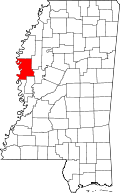
| State | Mississippi |
| County | Washington |
| Area | |
• Total | 1.91 sq mi (4.95 km2) |
| • Land | 1.91 sq mi (4.95 km2) |
| • Water | 0 sq mi (0.00 km2) |
| Elevation | 125 ft (38 m) |
| Population (2020) | |
• Total | 39 |
| • Density | 20.4/sq mi (7.89/km2) |
| Time zone | UTC-6 (Central (CST)) |
| • Summer (DST) | UTC-5 (CDT) |
| ZIP code | 38776 |
| GNIS feature ID | 2812752 [2] |
Stoneville is a census-designated place and unincorporated community located in northeastern Washington County, Mississippi. Deer Creek flows through Stoneville.
Contents
A post office was established in 1876, and remains open. Stoneville was incorporated in 1882, though it is no longer incorporated. [3]
Stoneville was a stop on the Yazoo and Mississippi Valley Railroad, established in the 1880s, and a stop on the Columbus and Greenville Railway, established in the 1920s. [3]

The Jamie Whitten Delta States Research Center is located in Stoneville. [4] George B. Vogt was a notable entomologist there. [5]
It was first named as a CDP in the 2020 Census which listed a population of 39. [6]