Wayside, Mississippi

Last updated

Wayside, Mississippi
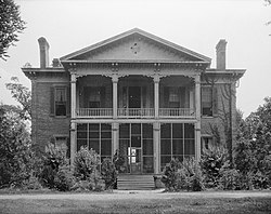
Belmont near Wayside.jpg
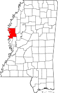
USA Mississippi location map.svg
Red pog.svg
Wayside, Mississippi
Coordinates: Mississippi#USA 33°16′08″N91°02′01″W / 33.26889°N 91.03361°W / 33.26889; -91.03361
Country United States
State Mississippi
County Washington
Elevation
[1]
121 ft (37 m)
Time zone UTC-6 (Central (CST))
  Summer (DST) UTC-5 (CDT)
ZIP code
38780
Area code 662
GNIS feature ID679401 [1]

Wayside is an unincorporated community in Washington County, Mississippi, United States.

The settlement has a post office and water tower. Wayside is located on Mississippi Highway 1 approximately 8 mi (13 km) south of Greenville. [2]

History

The Belmont Plantation was located in Wayside. The plantation home was completed in 1859, [3] and has been described as "one of the few antebellum homes in the region not burned by rampaging Union soldiers". [4] The extant home was placed on the National Register of Historic Places in 1972. [5]

Wayside was originally located directly on the Mississippi River at the eastern end of "American Bend", and the early settlement had a steamboat landing. The river changed course following a flood in 1858, cutting off the bend and creating an oxbow lake now called Lake Lee. [6] [7]

A branch of the Louisville, New Orleans and Texas Railway, completed in the late 1880s, passed through Wayside. [3]

In 1900, the population was 65. [8]

On October 9, 2009, a tornado destroyed three mobile homes, damaged 16 houses and knocked down trees. A fatality occurred in a mobile home, and two others were injured.[ citation needed ]

Related Research Articles

<span class="mw-page-title-main">Lake Village, Arkansas</span> City in Arkansas, United States

Lake Village is a city in and the county seat of Chicot County, Arkansas, United States. The population was 2,575 at the 2010 census. It is located in the Arkansas Delta. Lake Village is named for its location on Lake Chicot, an oxbow lake formed by the Mississippi River.

<span class="mw-page-title-main">Greenville, Mississippi</span> City in County, United States

Greenville is the ninth-most populous city in the U.S. state of Mississippi, and the largest city by population in the Mississippi Delta region. It is the county seat of Washington County. The population was 29,670 at the 2020 Census.

<span class="mw-page-title-main">Milliken's Bend, Louisiana</span> Extinct settlement along Mississippi River

Milliken's Bend is an extinct settlement that was located along the Mississippi River in Madison Parish, Louisiana, United States for about 100 years. In its heyday, the village had a boat landing, two streets of businesses, residences, churches, a four-room schoolhouse, a ferryman, and roads connecting it to Lake Providence, and Tallulah.

The Griffin–Spragins House is located in Refuge, Mississippi, approximately 10 mi (16 km) southwest of Greenville.

<span class="mw-page-title-main">Heathman, Mississippi</span> Unincorporated community in Mississippi, United States

Heathman is an unincorporated community in Sunflower County, Mississippi, United States. Heathman is located within the Mississippi Delta near U.S. Route 82 on Heathman Road, approximately 2 miles (3.2 km) west of Indianola and 2 miles (3.2 km) east of Holly Ridge.

<span class="mw-page-title-main">Franklin, Mississippi</span> Unincorporated community in Mississippi, United States

Franklin is an unincorporated community located in Holmes County, Mississippi. Mississippi Highway 17 passes through Franklin, which is approximately 7 miles (11 km) south of Lexington, the county seat, and approximately 12 miles (19 km) north of the town of Pickens.

<span class="mw-page-title-main">Coon Box, Mississippi</span> Extinct settlement, Jefferson County

Coon Box, also Coonbox and Raccoon Box, is a placename in Jefferson County, Mississippi, United States. Coon Box is 5.9 miles (9.5 km) north of Fayette. The Coon Box Fork Bridge, which is listed on the National Register of Historic Places, is located one mile southwest of Coon Box.

Princeton is a ghost town located in Washington County, Mississippi, United States.

<span class="mw-page-title-main">Lake Washington (Mississippi)</span> Oxbow lake in Washington County, Mississippi

Lake Washington is an oxbow lake in Washington County, Mississippi, United States.

<span class="mw-page-title-main">Ben Lomond, Mississippi</span> Unincorporated community in Mississippi, United States

Ben Lomond is a ghost town in Issaquena County, Mississippi, United States.

Kienstra is a ghost town located in Adams County, Mississippi, United States. South of the town was Kienstra Landing, located on the Mississippi River.

Artonish is a ghost town located in Wilkinson County, Mississippi, United States. South of the town was Artonish Landing, located on a stretch of the Mississippi River known as the "Homochitto Cutoff".

<span class="mw-page-title-main">Belmont Plantation (Wayside, Mississippi)</span> Historic house in Mississippi, United States

Belmont Plantation is an Antebellum plantation in Wayside, Washington County, Mississippi.

Leota is a ghost town located in Washington County, Mississippi, United States. The settlement, along with its river port Leota Landing, were at one time located directly on the Mississippi River.

Harbert Landing is a ghost town in Tunica County, Mississippi, United States.

Refuge is an unincorporated community located in Washington County, Mississippi, United States.

Sunflower Landing is an unincorporated community in Coahoma County, Mississippi, United States.

Huntington is a ghost town in Bolivar County, Mississippi, United States.

Mound Landing is a ghost town in Bolivar County, Mississippi, United States.

<span class="mw-page-title-main">Mississippi Highway 438</span> Highway in Mississippi

Mississippi Highway 438 is a state highway in western Mississippi. The route starts at MS 1 in Wayside and travels eastward. The road travels through farmland and intersects U.S. Route 61 and its old alignment near Arcola. MS 438 continues eastward and ends at Sunflower River Road and Kinlock Road on the Washington–Sunflower county line near Kinlock. The route was constructed around 1950, connecting from MS 1 to US 61. The route was extended to the Washington–Sunflower county line by 1958, and to US 49W in Inverness by 1960. The section east of the county line was removed from the route by 1974.

References

  1. 1 2 U.S. Geological Survey Geographic Names Information System: Wayside, Mississippi
  2. "Wayside Post Office". Geographic Names Information System . United States Geological Survey, United States Department of the Interior.
  3. 1 2 Hall, Russell S.; Nowell, Princella W.; Childress, Stacy (2000). Washington County, Mississippi. Arcadia. pp. 21, 46. ISBN   9780738506555.
  4. The Majesty of the Mississippi Delta. Pelican. 2005. p. 54. ISBN   9781455608249.
  5. "Belmont". National Park Service. Retrieved November 12, 2016.
  6. Halloran, Mary Helen Griffin (2009). A Mississippi Family: The Griffins of Magnolia Terrace, Griffin's Refuge, and Greenville 1800-1950. iUniverse. p. 98. ISBN   9781440142246.
  7. Bragg, Marion (1977). Historic Names and Places on the Lower Mississippi River (PDF). Mississippi River Commission. pp. 135, 136.
  8. Rowland, Dunbar (1907). Mississippi: Comprising Sketches of Counties, Towns, Events, Institutions, and Persons, Arranged in Cyclopedic Form. Vol. 2. Southern Historical Publishing Association. p. 945.