Nevada is a landlocked state in the Western region of the United States. It borders Oregon to the northwest, Idaho to the northeast, California to the west, Arizona to the southeast, and Utah to the east. Nevada is the 7th-most extensive, the 32nd-most populous, and the 9th-least densely populated of the U.S. states. Nearly three-quarters of Nevada's people live in Clark County, which contains the Las Vegas–Paradise metropolitan area, including three of the state's four largest incorporated cities. Nevada's capital is Carson City. Las Vegas is the largest city in the state.

Clark County is a county located in the U.S. state of Nevada. The land area of Clark County is 8,061 square miles (20,880 km2), or roughly the size of New Jersey. As of the 2020 census, the population was 2,265,461. Most of the county population resides in the Las Vegas Census County Divisions, which has 2,196,623 people as of the 2020 Census. It is by far the most populous county in Nevada, and the 11th-most populous county in the United States. It covers 7% of the state's land area but holds 73% of the state's population, making Nevada the most centralized state in the United States.
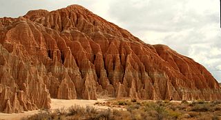
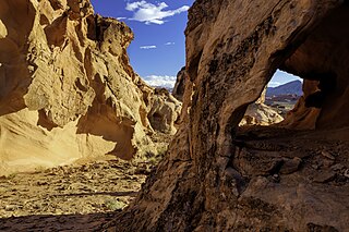
Cathedral Gorge State Park is a public recreation area and geologic preserve featuring a dramatic landscape of eroded soft bentonite clay covering almost 1,800 acres (730 ha) in Lincoln County, Nevada. The state park is located along U.S. Route 93 at the west end of State Route 319, two miles (3.2 km) northwest of the town of Panaca.

Old Las Vegas Mormon Fort State Historic Park is a state park of Nevada. It contains the Old Mormon Fort, the first permanent structure built in what would become Las Vegas fifty years later. In present-day Las Vegas, the site is at the southeast corner of Las Vegas Boulevard and Washington Avenue, less than one mile north of the downtown area and Fremont Street. This is the only U.S. state park located in a city that houses the first building ever built in that city. The fort was listed on the National Register of Historic Places on February 1, 1972. The site is memorialized with a tablet erected by the Church of Jesus Christ of Latter-day Saints in 1997, along with Nevada Historical Marker #35, and two markers placed by the Daughters of Utah Pioneers.

Floyd Lamb Park at Tule Springs is a 2,040-acre (830 ha) park in Las Vegas, Nevada. The park is centered on Tule Springs, a series of small natural spring-fed lakes that form an oasis in this part of the Mojave Desert. One of the larger urban retreats in the Las Vegas Valley, Tule Springs was once considered to be far out of town but is now encroached by development. The park includes the Tule Springs Ranch, Tule Springs Archaeological Site, Tule Springs Wash and four ponds available for fishing.

Lahontan State Recreation Area is a public recreation area surrounding Lake Lahontan, a 17-mile-long (27 km) impoundment of the Carson River, located approximately 18 miles (29 km) west of Fallon, Nevada. The reservoir features 69 miles (111 km) of shoreline and 11,200 acres (4,500 ha) of water when full. Much of the park lies below 4,000 feet (1,200 m) in elevation and is dominated by high desert sagebrush. Wooded areas of native cottonwoods and willow trees can be found along the shore of the lake. Primary access points to the park are along U.S. Route 50 near the Lahontan Dam and off U.S. Route 95 in the town of Silver Springs. A corridor known as Carson River Ranches connects Lahontan with Fort Churchill State Historic Park.

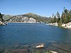
Cave Lake State Park is a public recreation area occupying more than 4,000 acres (1,600 ha) in the Schell Creek Range, adjacent to Humboldt National Forest, in White Pine County, Nevada. The state park is located at an elevation of 7,300 feet (2,200 m) five miles (8.0 km) southeast of Ely and is accessed via U.S. Route 50 and Success Summit Road. It features a 32-acre (13 ha) reservoir for fishing and flat-wake boating.

Fort Churchill State Historic Park is a state park of Nevada, United States, preserving the remains of a United States Army fort and a waystation on the Pony Express and Central Overland Routes dating back to the 1860s. The site is one end of the historic Fort Churchill and Sand Springs Toll Road. The park is in Lyon County south of the town of Silver Springs, on U.S. Route 95 Alternate, eight miles (13 km) south of U.S. Route 50. Fort Churchill was designated a National Historic Landmark in 1961. A 1994 park addition forms a corridor along the Carson River.

Mormon Station State Historic Park is a state park in downtown Genoa, Nevada, interpreting the site of the first permanent nonnative settlement in Nevada. Mormon Station was originally settled by Mormon pioneers and served as a respite for travelers on the Carson Route of the California Trail. The park offers artifacts and exhibits about the station's history housed in a replica of the 1851 trading post stockade which burned down in 1910.

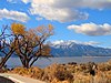
Washoe Lake State Park is a year-round public recreation area occupying over 3,700 acres (1,500 ha) on the southeast shore of Washoe Lake in Washoe County, Nevada. The state park lies to the east of Lake Tahoe, approximately five miles (8.0 km) north of Carson City near U.S. Route 395. The area around the park is known for its high winds making Washoe Lake a popular destination for windsurfers.

Kyle Ranch or Kiel Ranch, was one of the earliest ranches established in Nevada's Las Vegas Valley. Founded by Conrad Kiel in 1875, today the location of the former ranch is in North Las Vegas, where the city maintains the remnants of the site as the "Kiel Ranch Historic Park." The original adobe structure, one of the oldest buildings in Las Vegas, a wooden shed known as the "Doll House," and the cemetery are all that remain after loss of buildings through fire and neglect. Also within the park is an artesian well and a small wetlands, a reminder of what drew travelers and early settlers to the area. Presently the ranch's location is memorialized with Nevada Historical Marker number 224.

Tule Springs is one of the larger urban retreats in Las Vegas, Nevada, and the Las Vegas Valley. It is a significant desert ecosystem consisting of a series of small lakes that formed an oasis in this area of the Mojave Desert. Both the springs and the ranch are located within the Floyd Lamb Park at Tule Springs which is operated by the City of Las Vegas.
The History of Nevada as a state began when it became the 36th state on October 31, 1864, after telegraphing the Constitution of Nevada to the Congress days before the November 8 presidential election. Statehood was rushed to help ensure three electoral votes for Abraham Lincoln's reelection and add to the Republican congressional majorities.

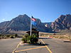
Berlin–Ichthyosaur State Park is a public recreation area and historic preserve that protects undisturbed ichthyosaur fossils and the ghost town of Berlin in far northwestern Nye County, Nevada. The state park covers more than 1,100 acres (450 ha) at an elevation of 7,000 feet (2,100 m) on the western slope of central Nevada's Shoshone mountain range, 23 miles (37 km) east of Gabbs.

Tule Springs Ranch and the remaining buildings are listed as a district on the United States National Register of Historic Places in Las Vegas, Nevada. Part of the area is included in the Tule Springs Archaeological Site and is listed on the U.S. National Register of Historic Places. The building are part of the Floyd Lamb Park at Tule Springs which is operated by the City of Las Vegas. Located about 20 miles from the Strip off U.S. Highway 95 north.
Elizabeth von Till Warren was an American historian and preservationist. She had expertise in the history of water development in the Mojave Desert and the Las Vegas Valley in particular. She also had expertise in the historical route of the Old Spanish Trail in Southern Nevada.
Gold Butte National Monument is a United States national monument located in Clark County, Nevada, northeast of Las Vegas and south of Mesquite and Bunkerville. The monument protects nearly 300,000 acres of desert landscapes featuring a wide array of natural and cultural resources, including rock art, sandstone towers, and important wildlife habitat for species including the Mojave Desert tortoise, bighorn sheep, and mountain lion. The area also protects historic ranching and mining sites such as the ghost town of Gold Butte, although little but mine openings, cement foundations, and a few pieces of rusting equipment remains. The monument is managed by the Bureau of Land Management.

Centennial Hills is a neighborhood in northwest Las Vegas, Nevada, United States. It is bordered by the Snow Mountain Paiute Reservation and Tule Springs Fossil Beds National Monument to the north, Lower Kyle Canyon and the Red Rock Canyon National Conservation Area to the west, Summerlin to the south, and North Las Vegas to the east. The Spring Mountains are visible to the west with Gass Peak in the Las Vegas Range to the north. Lone Mountain lies within the neighborhood.