Summerlin South, Nevada

Last updated

Summerlin South, Nevada
CDP
Clark County Nevada Incorporated Areas Summerlin South highlighted.svg
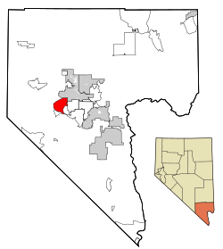
Location of Summerlin South in Clark County, Nevada
USA Nevada location map.svg
Red pog.svg
Summerlin South, Nevada
Usa edcp location map.svg
Red pog.svg
Summerlin South, Nevada
Coordinates: 36°7′35″N115°19′58″W / 36.12639°N 115.33278°W / 36.12639; -115.33278
CountryUnited States
State Nevada
County Clark
Government
  Type County Commission
  County Commissioner Justin Jones (D)
Area
[1]
  Total
9.69 sq mi (25.08 km2)
  Land9.69 sq mi (25.08 km2)
  Water0.00 sq mi (0.00 km2)
Population
 (2020)
  Total
30,744
  Density3,174.39/sq mi (1,225.67/km2)
Time zone UTC−8 (PST)
  Summer (DST) UTC−7 (PDT)
Area codes 702 and 725
FIPS code 32-70900
GNIS feature ID2410017

Summerlin South, also seen on maps as South Summerlin, is a census-designated place (CDP) in Clark County, Nevada, United States, on the western edge of the Las Vegas Valley and adjacent to the Red Rock Canyon National Conservation Area. It is so named because it is a southward extension of the master-planned community of Summerlin. Nearly all of Summerlin South is in ZIP code 89135. The population was 24,085 at the 2010 Census.

Contents

The Summerlin South Community Association is the main governmental entity of the area – it is a homeowners association for the entire community.

Summerlin South is considered to be one of the most prestigious neighborhoods in the Las Vegas Valley. [2] The area includes The Ridges, a guard-gated community consisting of custom and semi-custom homes in southwest Summerlin. In The Ridges, the average home price is over $2,000,000. [3]

Geography

It is bounded on the north by Charleston Boulevard, Hualapai Way to the east and Red Rock Canyon National Conservation Area to the west. Current development expands just below Russell Rd on the south but future developments will expand to Maule Ave. [4]

According to the United States Census Bureau, the CDP has a total area of 9.64 square miles (24.97 km2). [5]

Demographics

Historical population
CensusPop.Note
2000 3,735
2010 24,085544.8%
2020 30,74427.6%
U.S. Decennial Census [6]

As of the census of 2010, there were 24,085 people and 10,173 households residing in the CDP. The population density was 2,497.4 inhabitants per square mile (964.3/km2). The racial makeup of the CDP was 76.2% White, 4.4% African American, 0.4% Native American, 12.8% Asian, 0.4% Pacific Islander, 1.8% from other races, and 3.9% from two or more races. Hispanic or Latino of any race were 8.6% of the population.

There were 10,173 households, out of which 27.7% had children under the age of 18 living with them. 54.6% were married couples living together, and 33.3% were non-families. 25.7% of all households were made up of individuals, and 2.9% had someone living alone who was 65 years of age or older. The average household size was 2.37 and the average family size was 2.86.

In the CDP, the age distribution was 21.3% under the age of 18 and 78.7% over the age of 18. Age 65 and over made up 18% of the population. The median age was 42.9 years.

Between 2011–2013, median household income was $91,535 and mean household income was $139,061, almost double the US mean household income. [7]

See also

Related Research Articles

<span class="mw-page-title-main">Clark County, Nevada</span> County in Nevada, United States

Clark County is a county located in the U.S. state of Nevada, which also comprises the Las Vegas-Henderson-North Las Vegas, NV metropolitan statistical area. The land area of Clark County is 8,061 square miles (20,880 km2), or roughly the size of New Jersey. As of the 2020 census, the population was 2,265,461. Most of the county population resides in the Las Vegas Census County Divisions, which has 2,196,623 people as of the 2020 Census. It is by far the most populous county in Nevada, and the 11th-most populous county in the United States. It covers 7% of the state's land area but holds 73% of the state's population, making Nevada the most centralized state in the United States.

<span class="mw-page-title-main">Ridge Manor, Florida</span> Census-designated place in Florida, United States

Ridge Manor is a census-designated place (CDP) in Hernando County, Florida, United States. The population was 4,513 at the 2010 census.

<span class="mw-page-title-main">Iona, Florida</span> Census-designated place in Florida, United States

Iona is an unincorporated community and census-designated place (CDP) in Lee County, Florida, United States. The population was 16,908 at the 2020 census, up from 15,404 at the 2010 census. It is part of the Cape Coral-Fort Myers, Florida Metropolitan Statistical Area.

<span class="mw-page-title-main">Pine Ridge, Citrus County, Florida</span> Census-designated place in Florida, US

Pine Ridge is an unincorporated community and census-designated place (CDP) in Citrus County, Florida, United States. The population was 11,042 at the 2020 census, up from 9,598 at the 2010 census. It is part of the Homosassa Springs, Florida Metropolitan Statistical Area.

<span class="mw-page-title-main">Blue Diamond, Nevada</span> Census-designated place in Clark County, Nevada, United States

Blue Diamond is a census-designated place (CDP) in Clark County, Nevada, United States. The population was 268 at the 2020 census.

<span class="mw-page-title-main">Cal-Nev-Ari, Nevada</span> Census-designated place in Nevada, United States

Cal-Nev-Ari is a census-designated place on U.S. Route 95 in Clark County, Nevada, United States, near the state's southernmost point. As of the 2010 census, the town had a population of 244. The town's name is a syllabic abbreviation of California, Nevada and Arizona.

<span class="mw-page-title-main">Moapa, Nevada</span> Census-designated place in Nevada, United States

Moapa is an unincorporated town and census-designated place (CDP) in Clark County, Nevada, United States. The population was 1,025 at the 2010 census. It is the largest town in Clark County by land area. Both the second and the third tallest structures in Nevada, the Moapa Entravision Tower and the Moapa Kemp Tower respectively, are located in Moapa.

<span class="mw-page-title-main">Paradise, Nevada</span> Unincorporated town in Nevada, United States

Paradise is an unincorporated town and census-designated place (CDP) in Clark County, Nevada, United States, adjacent to the city of Las Vegas. It was formed on December 8, 1950. Its population was 191,238 at the 2020 census, making it the fifth-most-populous CDP in the United States; if it were an incorporated city, it would be the fifth-largest in Nevada. As an unincorporated town, it is governed by the Clark County Commission with input from the Paradise Town Advisory Board.

<span class="mw-page-title-main">Spring Valley, Nevada</span> Unincorporated town in the State of Nevada, United States

Spring Valley is an unincorporated town and census-designated place in Clark County, Nevada, United States, located 2 miles (3 km) west of the Las Vegas Strip. The population was 215,597 at the 2020 census. Spring Valley was formed in May 1981.

<span class="mw-page-title-main">Sunrise Manor, Nevada</span> Census-designated place in Clark County, Nevada, United States

Sunrise Manor is a census-designated place in Clark County, Nevada, United States, located on the western base of Frenchman Mountain, east of Las Vegas. The population was 205,618 at the 2020 census. If Sunrise Manor were to be incorporated, it would be one of the largest cities in Nevada. Sunrise Manor was formed in May 1957.

<span class="mw-page-title-main">Whitney, Nevada</span> Unincorporated town in the State of Nevada, United States

Whitney is an unincorporated town and census-designated place in Clark County, Nevada, United States. The population was 38,585 at the 2010 census.

<span class="mw-page-title-main">Spring Creek, Nevada</span> CDP in Nevada, United States

Spring Creek is a census-designated place (CDP) in central Elko County, in northeastern Nevada in the western United States. It mainly serves as a bedroom community for the businesses and industries in and around the nearby city of Elko. It is part of the Elko Micropolitan Statistical Area. The population was 12,361 at the 2010 census.

<span class="mw-page-title-main">Schurz, Nevada</span> Census-designated place in Nevada, United States

Schurz is an unincorporated community and census-designated place (CDP) in Mineral County, Nevada, United States. The population was 656 at the 2020 census. It is located on the Walker River Indian Reservation and is the burial place of Wovoka, the Paiute messiah who originated the Ghost Dance movement.

<span class="mw-page-title-main">Gabbs, Nevada</span> Unincorporated town in the State of Nevada, United States

Gabbs is an unincorporated town in Nye County, Nevada, United States. The population was 269 at the 2010 census. Located in northern Nye County, it is part of the Las Vegas–Henderson, NV CSA, making it at 321 miles (517 km) the most distant community from Las Vegas in the Las Vegas–Henderson combined statistical area.

Sun Valley is a census-designated place (CDP) in Washoe County, Nevada, United States. The population was 19,299 at the 2010 census. It is north of Reno and is part of the Reno–Sparks Metropolitan Statistical Area.

<span class="mw-page-title-main">Silver Ridge, New Jersey</span> Populated place in Ocean County, New Jersey, US

Silver Ridge is an unincorporated community and census-designated place (CDP) located within Berkeley Township, in Ocean County, in the U.S. state of New Jersey. As of the 2010 United States Census, the CDP's population was 1,133.

<span class="mw-page-title-main">Oglala, South Dakota</span> CDP in South Dakota, United States

Oglala is a census-designated place (CDP) in West Oglala Lakota Unorganized Territory equivalent, Oglala Lakota County, South Dakota, United States. The population was 1,282 at the 2020 census. Its location is in the northwest of the Pine Ridge Indian Reservation.

South Cleveland is a census-designated place (CDP) in Bradley County, Tennessee, United States. The population was 7,673 at the 2020 census. The community is located directly south of the city of Cleveland, Tennessee. It is included in the Cleveland Metropolitan Statistical Area.

<span class="mw-page-title-main">Bryn Mawr-Skyway, Washington</span> Census-designated place in Washington, United States

Bryn Mawr-Skyway is a census-designated place (CDP) in King County, Washington, United States. The population was 17,397 at the 2020 census.

<span class="mw-page-title-main">Gold Canyon, Arizona</span> Census-designated place in Arizona, United States

Gold Canyon is a census-designated place (CDP) and unincorporated community in Pinal County, Arizona, United States. The community is sometimes incorrectly called Gold Camp.

References

  1. "ArcGIS REST Services Directory". United States Census Bureau. Retrieved September 19, 2022.
  2. The Higley 1,000
  3. Neighborhood Tour:Summerlin
  4. Clark County Urban Planning Area (retrieved 2007-08-16)
  5. United States Census Bureau. Summerlin South CDP, Nevada
  6. "Census of Population and Housing". Census.gov. Retrieved June 4, 2016.
  7. "2011–2013 US Census Bureau Economic Characteristics for Summerlin South CDP". Archived from the original on January 27, 2015. Retrieved January 27, 2015.