This is an incomplete list of landmarks located in the Las Vegas metropolitan area.
Name | Image | Year | Comments | References |
---|---|---|---|---|
Welcome to Fabulous Las Vegas sign | 1959 | The "Welcome to Fabulous Las Vegas sign" located in the median at 5100 Las Vegas Boulevard South, is Las Vegas Strip Landmark. It was commissioned in May 1959 and erected soon after by Western Neon. The sign was designed by Betty Willis at the request of Ted Rogich, a local salesman who sold it to Clark County, Nevada. | [1] | |
Vegas Vic | 1951 | Vegas Vic is the unofficial name for a neon sign resembling a cowboy that was erected on the exterior of The Pioneer Club in Las Vegas in 1951. The sign can still be found at 25 E Fremont Street at the same place since 1951 on the outside of what used to be The Pioneer Club but is currently a souvenir shop owned by Schiff Enterprises. | ||
Hoover Dam | 1935 | Hoover Dam, originally known as Boulder Dam, is a dam located in the Black Canyon of the Colorado River between the border of Arizona and Nevada. It was constructed between 1931 and 1936, and was dedicated on September 30, 1935, by President Franklin Roosevelt. | ||
Las Vegas Strip | The Las Vegas Strip is a 4.2-mile (6.8 km) stretch of Las Vegas Boulevard South in Clark County, Nevada. Many of the largest hotel, casino and resort properties in the world are located on the Las Vegas Strip. Nineteen of the world's 25 largest hotels by room count are on the Strip, with a total of over 67,000 rooms. | |||
Downtown Las Vegas | 
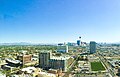
Downtown Las Vegas is the central business district of Las Vegas, Nevada. It is where the majority of the city's high-rise buildings are located and is the center for downtown gaming. | |||
Fremont Street Experience | 
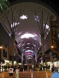
1995 | Fremont Street Experience (FSE) is a pedestrian mall and attraction in Downtown Las Vegas, Nevada. The FSE occupies the westernmost 5 blocks of Fremont Street, including the area known for years as "Glitter Gulch", and portions of some other adjacent streets. | ||
Fountains of Bellagio | 1998 | The Bellagio Fountains hotel and casino is a vast, choreographed water feature with performances set to light and music located at the front of Bellagio Hotel and Casino. | ||
Neon Museum | 1996 | The Neon Museum, also known as the Neon Boneyard or Neon Graveyard, features signs from old casinos. | [2] [1] | |
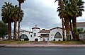
Little Church of the West | 1943 | The oldest building on the Las Vegas Strip, the Little Church of the West is a wedding chapel famous for celebrity weddings. | [2] | |
The city of Las Vegas Historic Preservation Commission (HPC) oversees preservation activities for buildings, structures, and places of historical and architectural significance. [3] The HPC review applications for the Historic Property Register, a list of locally significant historic places. [3]
Landmark name [4] | Image | Location | Built | NHRP date |
---|---|---|---|---|
Bonanza Underpass | East of 200 W Bonanza Rd | 1937 | January 28, 2004 | |
Floyd Lamb Park at Tule Springs Ranch | 9200 Tule Springs Rd | 1964 | September 23, 1981 | |
Frank Wait House | 901 E Ogden Ave | 1930 | N/A | |
Henderson House | 704 S 9th St | 1930 | N/A | |
Huntridge Theater | 1208 E Charleston Blvd | 1944 | July 22, 1993 | |
Jay Dayton Smith House | 624 S 6th St | 1931 | February 20, 1987 | |
La Concha Motel Lobby | 770 N Las Vegas Blvd | 1961 | N/A | |
Fifth Street School | 401 S 4th St | 1936 | N/A | |
Westside School | 330 W Washington Ave, Ward 5 | 1923 | N/A | |
Las Vegas High School (Las Vegas Academy) | 315 S 7th St | 1931 | September 24, 1986 | |
Las Vegas High School | ||||
Las Vegas Mormon Fort | 500 E Washington Ave | 1855 | December 12, 1978 | |
Las Vegas Springs(Big Springs) | 309 S Valley View Blvd | 500 AD | December 14, 1978 | |
Mesquite Club | 702 E St Louis Ave | 1961 | N/A | |
Morelli House | 861 S Bridger Ave | 1959 | June 3, 2012 | |
Moulin Rouge Hotel and Casino *demolished in 2010 | 840 W Bonanza Rd | 1955 | 1992 | |
U.S. Post Office and Courthouse(Mob Museum) | 300 Stewart Ave | 1933 | February 10, 1983 | |
Woodlawn Cemetery | 1500 N Las Vegas Blvd, Ward 5 | 1914 | November 21, 2006 | |
El Cortez Hotel and Casino | 600 Fremont Street | 1941 | February 22, 2013 | |
Harrison Boarding House | 1001 F Street | 1942 | N/A | |
Old Spanish Trail | 8150 Tara Ave | 1844 | August 22, 2001 | |
Wengert House | 600 E Charleston | 1938 | N/A | |
Helen Toland Residence | 1134 Comstock Dr | 1947 | N/A | |
Mesquitewood | 418 W Mesquite | 1955 | N/A | |
John Mull's Meats | 3730 Thom Blvd | 1953 | N/A | |
Eureka Locomotive | Address restricted | 1875 | January 12, 1995 | |
Tule Springs Archaeological Site | Address restricted | April 20, 1979 | ||
Green Shack*demolished | 2504 E. Fremont | 1932 | June 03, 1994 |
Source: [5]
Harlem is a neighborhood in Upper Manhattan, New York City. It is bounded roughly by the Hudson River on the west; the Harlem River and 155th Street on the north; Fifth Avenue on the east; and Central Park North on the south. The greater Harlem area encompasses several other neighborhoods and extends west and north to 155th Street, east to the East River, and south to Martin Luther King Jr. Boulevard, Central Park, and East 96th Street.
The Financial District of Lower Manhattan, also known as FiDi, is a neighborhood located on the southern tip of Manhattan in New York City. It is bounded by the West Side Highway on the west, Chambers Street and City Hall Park on the north, Brooklyn Bridge on the northeast, the East River to the southeast, and South Ferry and the Battery on the south.
Turtle Bay is a neighborhood in New York City, on the east side of Midtown Manhattan. It extends from roughly 43rd Street to 53rd Street, and eastward from Lexington Avenue to the East River's western branch. The neighborhood is the site of the headquarters of the United Nations and the Chrysler Building. The Tudor City apartment complex is next to the southeast corner of Turtle Bay.
Downtown Las Vegas is the central business district and historic center of Las Vegas, Nevada, United States. It is the original townsite, and the Downtown gaming area was the primary gambling district of Las Vegas prior to the Strip. As the urban core of the Las Vegas Valley, it features a variety of hotel and business highrises, cultural centers, historical buildings and government institutions, as well as residential and retail developments. Downtown is located in the center of the Las Vegas Valley and just north of the Las Vegas Strip, centered on Fremont Street, the Fremont Street Experience and Fremont East. The city defines the area as bounded by I-15 on the west, Washington Avenue on the north, Maryland Parkway on the east and Sahara Avenue on the south.
This is a list of the National Register of Historic Places listings in St. Louis County, Missouri.
Historic districts in the United States are designated historic districts recognizing a group of buildings, archaeological resources, or other properties as historically or architecturally significant. Buildings, structures, objects, and sites within a historic district are normally divided into two categories, contributing and non-contributing. Districts vary greatly in size and composition: a historic district could comprise an entire neighborhood with hundreds of buildings, or a smaller area with just one or a few resources.
In the law regulating historic districts in the United States, a contributing property or contributing resource is any building, object, or structure which adds to the historical integrity or architectural qualities that make the historic district significant. Government agencies, at the state, national, and local level in the United States, have differing definitions of what constitutes a contributing property but there are common characteristics. Local laws often regulate the changes that can be made to contributing structures within designated historic districts. The first local ordinances dealing with the alteration of buildings within historic districts was enacted in Charleston, South Carolina in 1931.
The Gold Coast Historic District is located in Midtown Omaha, Nebraska. Listed on the National Register of Historic Places in 1997, this historic district covers approximately a 30 block area roughly bounded by 36th, 40th, Jones, and Cuming Streets. The neighborhood housed many of Omaha's cultural and financial leaders between 1900 and 1920, taking over from Omaha's original Gold Coast in prominence.
This is a list of the National Register of Historic Places listings in Newport County, Rhode Island.
Hosmer Library, originally known as the Thirty-Sixth Street Branch Library, is a branch library of the Hennepin County Library system serving the Central neighborhood of Minneapolis, Minnesota, United States. It was named the Hosmer Library in honor of James Kendall Hosmer and was listed on the National Register of Historic Places in 2000.
The Las Vegas High School Historic District in Las Vegas, Nevada is a historic district which includes 11 buildings on the 15 acres (6.1 ha) campus of the school district. It was listed on the National Register of Historic Places in 2022.
Las Vegas High School Neighborhood Historic District, is a historic district which was listed on the National Register of Historic Places in 1991. The Las Vegas High School Academic Building and Gymnasium, already listed on the National Register in 1986, is included as a contributing property within the district. That property was later expanded to include Fraser Hall in 2021 and to include the entire 15 acres (6.1 ha) campus of the Las Vegas High School in 2022.
This is a list of the National Register of Historic Places listings in Phoenix, Arizona.
This is a list of the National Register of Historic Places listings in East Baton Rouge Parish, Louisiana.
This is a list of the National Register of Historic Places listings in Todd County, Minnesota. It is intended to be a complete list of the properties and districts on the National Register of Historic Places in Todd County, Minnesota, United States. The locations of National Register properties and districts for which the latitude and longitude coordinates are included below, may be seen in an online map.