Buster Falls, Nevada

Last updated

Buster Falls, now a ghost town, was a mining camp in El Dorado Canyon above Huse Spring and the Techatticup Mine in the Colorado Mining District during the time of the American Civil War. The source of the name of the camp is unknown. Its site lay along the canyon a mile above the site of Lucky Jim Camp. [1] [2] :15, and Note 33 [3] :611 The site would be just above the El Dorado Canyon's confluence with Copper Canyon. [4]

Ghost town city depopulated of inhabitants and that stays practically intact

A ghost town is an abandoned village, town, or city, usually one that contains substantial visible remains. A town often becomes a ghost town because the economic activity that supported it has failed, or due to natural or human-caused disasters such as floods, prolonged droughts, government actions, uncontrolled lawlessness, war, pollution, or nuclear disasters. The term can sometimes refer to cities, towns, and neighbourhoods that are still populated, but significantly less so than in past years; for example, those affected by high levels of unemployment and dereliction.

El Dorado Canyon is a canyon in southern Clark County, Nevada famed for its rich silver and gold mines. The canyon was named in 1857 by steamboat entrepreneur Captain George Alonzo Johnson when gold and silver was discovered here. It drains into the Colorado River at the former site of Nelson's Landing.

Techatticup Mine, is a former gold mine, now a tourist attraction. It is located at an elevation of 2,477 feet (755 m), midway in Eldorado Canyon, in Clark County, Nevada.

Contents

History

Founded in 1862, during the time of the American Civil War, Buster Falls was the home of miners sympathetic to the Union cause. A mile down the canyon at the foot of the Techatticup Mine, lay Lucky Jim Camp, the home of miners sympathetic to the Confederate cause. [2] :15, and Note 33 [3] :611

American Civil War Civil war in the United States from 1861 to 1865

The American Civil War was a war fought in the United States from 1861 to 1865, between the North and the South. The Civil War is the most studied and written about episode in U.S. history. Primarily as a result of the long-standing controversy over the enslavement of black people, war broke out in April 1861 when secessionist forces attacked Fort Sumter in South Carolina shortly after Abraham Lincoln had been inaugurated as the President of the United States. The loyalists of the Union in the North proclaimed support for the Constitution. They faced secessionists of the Confederate States in the South, who advocated for states' rights to uphold slavery.

Union (American Civil War) United States national government and the 20 free states and five border slave states

During the American Civil War (1861–1865), the Union, also known as the North, referred to the United States of America and specifically to the national government of President Abraham Lincoln and the 20 free states, as well as 4 border and slave states that supported it. The Union was opposed by 11 southern slave states that formed the Confederate States of America, also known as "the Confederacy" or "the South".

Lucky Jim Camp sometimes called Lucky Camp is a ghost town site in Clark County, Nevada. It was within New Mexico Territory when founded in 1862.

Site today

This site appears to be currently occupied by buildings 0.4 miles southwest of the center of Nelson, Nevada on Nevada State Route 165.

Nelson, Nevada Census-designated place in Nevada, United States

Nelson is a census-designated place in Clark County, Nevada, United States. The community is in the Pacific Standard Time zone. The location of Nelson is in El Dorado Canyon, Eldorado Mountains. The town is in the southeast region of the Eldorado Valley. As of the 2010 census it had a population of 37.

Nevada State Route 165 highway in Nevada

State Route 165 is a state highway near the southern end of the U.S. state of Nevada. The road connects the town of Nelson to U.S. Route 95. The road originated in the 1940s and was one section of former State Route 60 until the 1970s.

Related Research Articles

Comstock Lode

The Comstock Lode is a lode of silver ore located under the eastern slope of Mount Davidson, a peak in the Virginia Range in Nevada. It was the first major discovery of silver ore in the United States, and named after American miner Henry Comstock.

Ruth, Nevada CDP in Nevada, United States

Ruth is a census-designated place (CDP) in White Pine County, Nevada, United States. Founded in 1903, it had a population of 440 at the 2010 census.

Silver mining in the United States

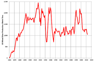
Silver mining in the United States began on a major scale with the discovery of the Comstock Lode in Nevada in 1858. The industry suffered greatly from the demonetization of silver in 1873 by the Coinage Act of 1873, known pejoratively as the "Crime of 73", but silver mining continues today.

Eldorado Mountains

The Eldorado Mountains, also called the El Dorado Mountains, are a north-south trending mountain range in southeast Nevada bordering west of the south-flowing Colorado River; the endorheic Eldorado Valley borders the range to the west, and the range is also on the western border of the Colorado River's Black Canyon of the Colorado, and El Dorado Canyon on the river. The range is 50 miles (80 km) southeast of Las Vegas, Nevada; and the Eldorado Mountains connect with the Highland and Newberry mountains.

Sageland, California Unincorporated community in California, United States

Sageland is an unincorporated community in Kern County, California. It is located near Kelso Creek 3.5 miles (5.6 km) west-northwest at the base of the Piute Mountains, at an elevation of 4,026 feet (1,227 m).

Steamboats of the Colorado River

Steamboats on the Colorado River operated from the river mouth at the Colorado River Delta on the Gulf of California in Mexico, up to the Virgin River on the Lower Colorado River Valley in the Southwestern United States from 1852 until 1909, when the construction of the Laguna Dam was completed. The shallow draft paddle steamers were found to be the most economical way to ship goods between the Pacific Ocean ports and settlements and mines along the lower river, putting in at landings in Sonora state, Baja California Territory, California state, Arizona Territory, New Mexico Territory, and Nevada state. They remained the primary means of transportation of freight until the advent of the more economical railroads began cutting away at their business from 1878 when the first line entered Arizona Territory.

Alturas, now a ghost town, was a mining camp in El Dorado Canyon near the Techatticup Mine in the Colorado Mining District of New Mexico Territory.

Louisville, which is now a ghost town, was a mining camp in El Dorado Canyon near the Techatticup Mine in the Eldorado Mining District, of New Mexico Territory. The camp was probably named for Nat S. Lewis, the superintendent of the Techatticup Mine in the 1860s, and camp doctor.

San Juan or Upper Camp is a ghost town that was a mining camp of the Eldorado Mining District. It was located in the upper reach of El Dorado Canyon, just below the present day location of Nelson in Clark County, Nevada.

El Dorado City, which is now a ghost town, was a mining camp in the Colorado Mining District at the mouth of January Wash at its confluence with El Dorado Canyon. It was located about a mile down the canyon from Huse Spring, at an elevation of 2382 feet. Its site was located nearby to the south southeast of the Techatticup Mine the primary source of the ore its mill processed.

Colorado City is now a ghost town, in Clark County, Nevada, located under Lake Mohave at the mouth of El Dorado Canyon.

Potosi or Potosi Camp, was called Crystal City in the 1870s, a mining ghost town in Clark County, Nevada. It lies at an elevation of 5705 feet.

Colorado Mining District was primarily a silver and gold mining district organized in El Dorado Canyon, New Mexico Territory on the west shore of the Colorado River in what is now Clark County, Nevada. The Colorado District was part of Arizona Territory from 1863 to 1869. In 1869, the land of Arizona Territory north and west of the Colorado River east to the 114th meridian of longitude, including the Colorado District, was turned over to Nevada.

John Thomas Moss was an American frontiersman, prospector, and miner, who discovered several new mining districts in what is now Arizona and Nevada. After living with and learning the languages of many of the tribes in the area, he was a go between and peacemaker between American miners and local Native Americans, in the Southwestern United States.

Quartette or Quartette Mill or Quartette Landing, was a mining settlement, location of the stamp mill of the Quartette Mining Company, owner of the largest mine in the Searchlight Mining District and a steamboat landing on the Colorado River, in what is now Clark County, Nevada. It lay at an elevation of 646 feet.

Johntown, Nevada Ghost Town in Nevada, United States

Johntown is a ghost town in Lyon County, Nevada United States. It was originally an important mining camp in Gold Canyon, midway between Dayton and Silver City. In the late 1850s, Johntown was the largest mining camp in the western Utah Territory.

References

  1. U.S. Geological Survey Geographic Names Information System: Lucky Jim Camp
  2. 1 2 John M. Townley, Early Development of El Dorado Canyon and Searchlight Mining Districts, NEVADA HISTORICAL SOCIETY QUARTERLY, SPRING 1968, VOLUME XI Number 1, Nevada Historical Society, Reno, 1968
  3. 1 2 James Graves Scrugham, Nevada: A Narrative of the Conquest of a Frontier Land, Vol. 1, American Historical Society, Chicago, 1935
  4. U.S. Geological Survey Geographic Names Information System: Copper Canyon

Coordinates: 35°42′10″N114°49′13″W / 35.70278°N 114.82028°W / 35.70278; -114.82028

Geographic coordinate system Coordinate system

A geographic coordinate system is a coordinate system that enables every location on Earth to be specified by a set of numbers, letters or symbols. The coordinates are often chosen such that one of the numbers represents a vertical position and two or three of the numbers represent a horizontal position; alternatively, a geographic position may be expressed in a combined three-dimensional Cartesian vector. A common choice of coordinates is latitude, longitude and elevation. To specify a location on a plane requires a map projection.