Paradise is an unincorporated town[2] and census-designated place (CDP) in Clark County, Nevada, United States, adjacent to the city of Las Vegas. It was formed on December 8, 1950. Its population was 191,238 at the 2020 census, making it the fifth-most-populous CDP in the United States; if it were an incorporated city, it would be the fifth-largest in Nevada.[3] As an unincorporated town, it is governed by the Clark County Commission with input from the Paradise Town Advisory Board.
The southern part of the Las Vegas Valley was referred to as Paradise Valley as early as 1910, owing to a high water table that made the land particularly fertile for farming.[5][6] County commissioners established a Paradise school district in 1914.[7]
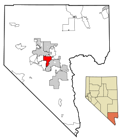
Neighborhoods on the east side of Paradise
In 1950, Mayor Ernie Cragin of Las Vegas sought to annex the Las Vegas Strip, which was unincorporated territory, to expand the city's tax base to fund his ambitious building agenda and pay down the city's rising debt.[8] A group of casino executives, led by Gus Greenbaum of the Flamingo, lobbied the county commissioners for town status, which would prevent the city from annexing the land without the commission's approval.[8] The commission voted to create the unincorporated town of Paradise on December 8, 1950.[9][10] The town encompassed a strip one mile (1.6km) wide and four miles (6.4km) long, from the southern city limits of Las Vegas to just south of the Flamingo.[10] The town board initially consisted of five casino managers, chaired by Greenbaum.[10][11]
A month after its establishment, the town was expanded to include the residential areas of Paradise Valley, giving it a total area of 54 square miles (140km2).[11] Months later, however, county officials reportedly had determined that the town had not been properly established because the petition for the town's formation had an insufficient number of signatures and because it had violated a state law forbidding formation of a town spanning multiple school districts.[12] On August 20, 1951, county commissioners accepted petitions to create two new towns covering the area of the putative town.[13] Town "A" of Paradise included the areas that lay within a Las Vegas school district, extending from the city limits to a point one mile south, while Town "B" included the areas within the Paradise school district.[12]
In 1953, Town A was renamed as Winchester, and Town B became known simply as Paradise.[14]
In 1975, Nevada enacted a law that would have incorporated Paradise (along with Sunrise Manor and Winchester) into the City of Las Vegas.[15] Before it could take effect, however, the bill was struck down as unconstitutional by the Nevada Supreme Court.[16][17]
The deadliest fire that occurred in the entire Las Vegas Valley was the MGM Grand fire on November 21, 1980. In the early morning hours, a deli counter had an electrical short that resulted in a fire in the walls of the hotel. The MGM Grand was built to the fire code of 1973, which did not require sprinkler systems, so sprinklers were only installed in the kitchens and theater. The fire traveled in the walls of the hotel, damaging the fire alarm system.[18] As the fire burned, toxic smoke entered the ventilation system, traveling to the rooms of the hotel. Guests broke windows to get fresh air, while waiting for rescue from firemen. Eighty-five people died in the fire, with two more dying later, bringing the death toll to 87. In addition to those who died, nearly 700 people were injured in the fire.[19] This fire contributed to a widespread change in the requirements for fire safety in hotels.[19]
On October 1, 2017, the deadliest mass shooting in the United States by a lone gunman occurred in Paradise when 64-year-old Stephen Paddock opened fire on the crowd attending the Route 91 Harvest music festival on the Strip from his 32nd-floor suite in the Mandalay Bay hotel.[20] He fired more than 1,000 rounds, killing 60 people and wounding at least 413 others.[21] The ensuing panic brought the total number of injured to about 867. Around an hour later, he was found dead in his room from a self-inflicted gunshot wound.[22]
On January 1, 2025, around 8:39 am (PST), an improvised explosive device exploded in a Tesla Cybertruck parked outside the main entrance of the Trump International Hotel Las Vegas in Paradise. The driver and alleged perpetrator was Matthew Alan Livelsberger, an American-born, active-duty United States Army Special Forces soldier from Colorado Springs, Colorado.[23] He was on leave from overseas duty and died from a self-inflicted gunshot wound to the head immediately before the explosion.[23] Seven bystanders were injured by the blast.[23] Authorities found that the vehicle contained firework mortars and gas canisters, which had fueled the explosion and fire. Per a note from Livelsberger, "the explosion was a stunt meant to be a 'wake up call' for the nation’s troubles".[24]
Geography
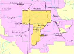
According to the United States Census Bureau, the census-designated place (CDP) of Paradise (which may not coincide exactly with the town boundaries) has a total area of 46.7 square miles (121km2), all of it land.
The official town boundaries are bordered by Desert Inn Road to the north, Nellis Boulevard to the east, Sunset Road to the south and Decatur Boulevard to the west. There is a southern finger between Bermuda Road and Eastern Avenue south to Silverado Ranch Boulevard. South of Russell Road, the eastern border stairsteps on a rough 45-degree angle toward the corner of Eastern and Robindale Road, and there is an additional finger surrounding Interstate 215 east to St. Rose Parkway.[25]
As of the census[28] of 2000, there were 186,070 people, 77,209 households, and 43,314 families residing in the CDP. The population density was 3,947.3 inhabitants per square mile (1,524.1/km2). There were 85,398 housing units at an average density of 1,811.6 per square mile (699.5/km2). The racial makeup of the CDP was 72.51% White, 6.59% African American, 0.77% Native American, 6.52% Asian, 0.59% Pacific Islander, 8.37% from other races, and 4.65% from two or more races. Hispanic or Latino of any race were 23.47% of the population.
In 2020 there were 80,732 households, out of which 23.9% had children under the age of 18 living with them, 30.6% were married couples living together, 29.4% had a female householder with no partner present, and 30.8% had a male householder with no partner present. 36.2% of all households were made up of individuals, and 10.9% had someone living alone who was 65 years of age or older.[27]
In the CDP, 21.4% was under the age of 19, 7% from 20 to 24, 29.6% from 25 to 44, 26.6% from 45 to 64, and 15.4% was 65 years of age or older. The median age was 39 years. For every 100 females, there were 105.6 males. For every 100 females age 20 and over, there were 105.4 males.[27]
The median income for a household in the CDP was $48,032. The median income for a family was $61,743 versus $72,654 for married couple families. The per capita income for the CDP was $68,858. 16.8% of the population and 11.8% of families were below the poverty line. 15.5% of males were living below the poverty line versus 18.2% of females. 19.3% of families with children under the age of 18 and 5.6% of those 65 and older were living below the poverty line.[27]
Also, since 2004, the Las Vegas Summer League, organized by the National Basketball Association (NBA), is played in the Thomas & Mack Center and in the Cox Pavilion.[37] Many NCAA College Basketball Tournament conferences are also hosted at the Thomas & Mack Center in March every year.[38]
Since 1985, almost every December the National Finals Rodeo has been held at the Thomas & Mack Center. The one exception was in 2020, when the event was held in Arlington, Texas, at Globe Life Field due to public health concerns during the COVID-19 pandemic.[39] The contract extension signed in June 2024 means that the finals will continue to be held at the Thomas & Mack Center until at least 2035.[40]
Paradise has also been the site of many prominent combat sports events, such as boxing and MMA, with Las Vegas being considered by many as the "fight capital of the world."[42]
This page is based on this Wikipedia article Text is available under the CC BY-SA 4.0 license; additional terms may apply. Images, videos and audio are available under their respective licenses.