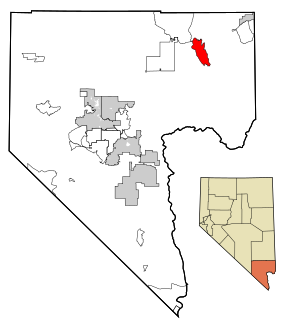
Moapa Valley is an unincorporated town in Clark County, Nevada, United States. As of the 2010 census, it had a population of 6,924. The valley in which the community lies, also named Moapa Valley, is about 40 miles (64 km) long and lies roughly northwest to southeast.
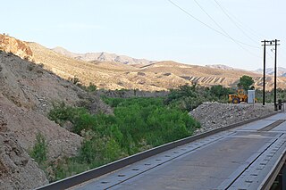
The Meadow Valley Wash is a southern Nevada stream draining the Meadow Watershed that is bordered on three sides by the Great Basin Divide. The wash's Lincoln County headpoint is in the Wilson Creek Range, and the wash includes two upper confluences. Panaca is along the upper wash, and downstream of Caliente is the wash's confluence with its east fork. Just prior to the junction with the Muddy River, the wash flows from Lincoln County into northeastern Clark County. It flows into the Muddy in the Moapa Valley just west of Glendale adjacent to Interstate 15 approximately 40 miles (64 km) northwest of Las Vegas.

St. Thomas, Nevada is a ghost town in Clark County, Nevada, near where the Muddy River flows into the Colorado River. St. Thomas was purchased by the US Federal Government and abandoned as the waters of Lake Mead submerged the town in the 1930s. However, as the level of Lake Mead dropped in the 2000s, the ruins of the town resurfaced. It is now located within the Lake Mead National Recreation Area.

The Muddy River, formerly known as the Moapa River, is a short river located in Clark County, in southern Nevada, United States. It is in the Mojave Desert, approximately 60 miles (97 km) north of Las Vegas.

Logandale is located in Clark County, Nevada. It was an unincorporated town in Clark County until 1981 when it was merged with Overton to create the unincorporated town of Moapa Valley. The community is the home of the annual Clark County Fair and Rodeo. The Las Vegas Metropolitan Police Department patrols the town.
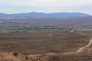
Overton is a community that is part of the unincorporated town of Moapa Valley in Clark County, Nevada. Overton is on the north end of Lake Mead. It is home to Perkins Field airport and Echo Bay Airport.

The Mormon Mountains are located in Lincoln and Clark counties in Nevada, between 16 and 28 miles (45 km) northwest of Mesquite on I–15 in the Virgin Valley, east of the Meadow Valley Mountains and Meadow Valley and northeast of Moapa Valley. The highest point in the range is Mormon Peak, at 7,414 feet (2,260 m) above sea level. Another smaller mountain range lies to the east, called the East Mormon Mountains. The south fork of the Toquop Wash drains the east side of the range and continues on through the N–S linear ridge of the East Mormon Mountains.

Joseph Stacy Murdock was an American colonizer, leader, and Latter-day Saint hymn writer. He wrote the words to "Come Listen to a Prophet's Voice."

The Meadow Valley Mountains is a mountain range in Lincoln and Clark counties in southern Nevada. The range is a narrow north to northeast trending ridgeline with a length of about 40 miles (64 km). The Clover Mountains lie to the north, Meadow Valley Wash and the Mormon Mountains to the east, the Moapa Valley to the southeast, Arrow Canyon Range to the south, Coyote Springs Valley to the southwest and the Kane Springs Valley and Delamar Mountains to the west and northwest.

The Church of Jesus Christ of Latter-day Saints in Nevada refers to The Church of Jesus Christ of Latter-day Saints and its members in Nevada. Nevada has the 7th most Members of the Church of any U.S. state, and the fourth-highest percentage of Members. The LDS Church is the 2nd largest denomination in Nevada, behind the Roman Catholic Church.

Barclay is a town in Lincoln County, Nevada, United States. Originally a Mormon settlement in the late 1860s, it has few residents and appears on several ghost town lists. The Barclay post office closed in 1910. Main sites in the town include an old Mormon cemetery, and an abandoned Post Office, the latter being one of the few remaining buildings in the town.

Rioville, Nevada was a settlement founded by Latter-day Saints in what they thought was Utah Territory in 1869, now under Lake Mead and within Clark County, Nevada.

Callville Bay is a waterway on the northwestern side of Lake Mead in the U.S. state of Nevada. It has a marina and camping resort. Situated east of Las Vegas and upstream from Las Vegas Bay, it lies within the Lake Mead National Recreation Area, which was established in 1935. Its name derives from the settlement of Callville which was established in 1865 by Anson Call under a directive led by Brigham Young. Though the settlement was abandoned in 1869, and submerged under Lake Mead when the Colorado River was dammed, Callville Bay retained the name.

Callville is a former settlement of Clark County in the U.S. state of Nevada. Abandoned in 1869, it was submerged under Lake Mead when the Colorado River was dammed, Callville Bay retaining the name. At one time, it was noted to be the southernmost outpost of the Mormon settlement.
Simonsville is a ghost town in Clark County, Nevada, that was located on the east bank of the Muddy River west of the south end of the Overton Airport in the Moapa Valley.
Stone's Ferry is a former settlement founded by members of The Church of Jesus Christ of Latter-day Saints and ferry crossing of the Colorado River between Nevada and Arizona, in Clark County, Nevada, United States.
Johnnie is a populated place in Nye County, in the U.S. state of Nevada about 15 miles north of Pahrump.
Bullionville is a ghost town in Lincoln County, Nevada, United States, 1/4 mile east of U.S. Route 93, one mile north of Panaca and 10 miles (16 km) south of Pioche. The town prospered between 1870 and 1882, and is now abandoned.
Tempiute is a ghost town in Lincoln County, Nevada United States.


