Cold Creek, Nevada

Last updated
Cold Creek
Cold Creek, Nevada.jpg
Cold Creek, Nevada
USA Nevada location map.svg
Red pog.svg
Cold Creek
Usa edcp location map.svg
Red pog.svg
Cold Creek
Coordinates: 36°24′53″N115°44′26″W / 36.41472°N 115.74056°W / 36.41472; -115.74056
Country United States
State Nevada
County Clark
Named for Cold Creek
Elevation
4,803 ft (1,464 m)
Time zone UTC-8 (Pacific (PST))
  Summer (DST) UTC-7 (PDT)
ZIP code
89124
Area code(s) 702/725
GNIS feature ID859284 [1]
Website Official website

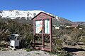
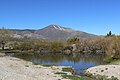
Cold Creek is an unincorporated community in Clark County, Nevada, United States located within the Spring Mountains National Recreation Area and approximately 28 miles by road from the Las Vegas city limits. [1] Cold Creek is named for the stream that flows through the community.

Contents

Cold Creek is a popular community for residents of Las Vegas and nearby locations to purchase second homes, away from large cities. The community's isolated location provides little light pollution coming from Las Vegas at night. Cold Creek has a homeowners association. [2]

History

In the 1930s, Cold Creek served as a dude ranch called Cold Creek Ranch. Stacy Irvin, curator of education at the Nevada State Museum, says, “Dude ranches were popular after the law for quickie divorces was passed in Nevada. Women would stay there for six weeks in order to get Nevada residency and be eligible for a divorce." [3] The ranch now exists as a historic site.

In June 1981, the Mack's Canyon Fire burned 6,500 acres of forest on Bonanza Peak, just southwest of Cold Creek. The scar caused by the wildfire is still visible, with only sparse vegetation and plant remains populating the area as of 2023. [4] [5]

Cold Creek Road looking west Cold Creek Road.jpg
Cold Creek Road looking west

Infrastructure

Cold Creek is served by the Clark County Fire Department with a fire station and has no commercial businesses. The community is primarily accessed by Cold Creek Road, a paved road which heads northeast from the community to intersect with U.S. Route 95 at the High Desert State Prison. [6]

Cold Creek is an off-the-grid community and relies on power from solar panels. [7]

Wildlife

Wild mustang in Cold Creek Wild Mustang (19792213999).jpg
Wild mustang in Cold Creek

Located within the 275,575 acre Bureau of Land Management (BLM) Wheeler Pass Herd Management Area (HMA), the Cold Creek Herd is one of the final remaining wild horse herds near Las Vegas. [8] The herd is made up of descendants of 1800s horse trade escapees and horses abandoned by Native Americans, Las Vegas settlers, ranchers, and prospectors in the area that moved to the Spring Mountains. [9] BLM currently estimates a smaller population of 47-66 wild horses in the HMA, [10] as, due to a drought and food depletion, BLM had previously removed and relocated 236 of the wild horses from the range. The Wheeler Pass HMA is also home to burros, elk, mule deer, coyotes, bobcats, jackrabbits, and mountain lions. [9]

Recreation

Cold Creek is located within the Spring Mountains National Recreation Area and has Cold Creek Ranch Historic Site. Parking lots serve multiple trails in the area which are popularly traveled on horseback.

Willow Creek Campground, located west of Cold Creek, is accessible from the community via Wheeler Pass Road.

Bonanza Trailhead and Group Camp, located south of Cold Creek, is accessible from the community via Bonanza Camp Road. [11]

Related Research Articles

<span class="mw-page-title-main">Clark County, Nevada</span> County in Nevada, United States

Clark County is a county located in the U.S. state of Nevada. As of the 2020 census, the population was 2,265,461. Most of the county population resides in the Las Vegas Census County Divisions, which hold 2,196,623 people as of the 2020 Census, across 435 square miles (1,130 km2). It is by far the most populous county in Nevada, and the 11th most populous county in the United States. It covers 7% of the state's land area but holds 73% of the state's population, making Nevada the most centralized state in the United States.

<span class="mw-page-title-main">Red Rock Canyon National Conservation Area</span> National conservation area in Nevada

The Red Rock Canyon National Conservation Area in Clark County, Nevada, United States, is an area managed by the Bureau of Land Management as part of its National Landscape Conservation System, and protected as a National Conservation Area. It is about 15 miles (24 km) west of Las Vegas, and is easily seen from the Las Vegas Strip. More than three million people visit the area each year.

<span class="mw-page-title-main">Black Rock Desert</span> Northwest Nevada dry lake

The Black Rock Desert is a semi-arid region of lava beds and playa, or alkali flats, situated in the Black Rock Desert–High Rock Canyon Emigrant Trails National Conservation Area, a silt playa 100 miles (160 km) north of Reno, Nevada that encompasses more than 300,000 acres (120,000 ha) of land and contains more than 120 miles (200 km) of historic trails. It is in the northern Nevada section of the Great Basin with a lakebed that is a dry remnant of Pleistocene Lake Lahontan.

<span class="mw-page-title-main">Mustang</span> Free-roaming horse of the Western US

The mustang is a free-roaming horse of the Western United States, descended from horses brought to the Americas by the Spanish. Mustangs are often referred to as wild horses, but because they are descended from once-domesticated animals, they are actually feral horses. The original mustangs were Colonial Spanish horses, but many other breeds and types of horses contributed to the modern mustang, now resulting in varying phenotypes. Some free-roaming horses are relatively unchanged from the original Spanish stock, most strongly represented in the most isolated populations.

<span class="mw-page-title-main">Las Vegas Valley</span> Metropolitan area in Nevada, United States

The Las Vegas Valley is a major metropolitan area in the southern part of the U.S. state of Nevada, and the second largest in the Southwestern United States. The state's largest urban agglomeration, the Las Vegas Metropolitan Statistical Area is coextensive since 2003 with Clark County, Nevada. The Valley is largely defined by the Las Vegas Valley landform, a 600 sq mi (1,600 km2) basin area surrounded by mountains to the north, south, east and west of the metropolitan area. The Valley is home to the three largest incorporated cities in Nevada: Las Vegas, Henderson and North Las Vegas. Eleven unincorporated towns governed by the Clark County government are part of the Las Vegas Township and constitute the largest community in the state of Nevada.

The Spring Mountains National Recreation Area (SMNRA) is a U.S. national recreation area, administered by the U.S. Forest Service, west of Las Vegas, Nevada. It covers over 316,000 acres. The area runs from low meadows, to the 11,918-foot (3,633 m) Mount Charleston. The SMNRA is a part of the Humboldt-Toiyabe National Forest. It adjoins the Red Rock Canyon National Conservation Area, which is administered by the Bureau of Land Management.

<span class="mw-page-title-main">Mount Charleston Wilderness</span> Protected wilderness in southern Nevada

The Mount Charleston Wilderness Area is located west of Las Vegas in the southern part of the state of Nevada in the western United States. It was created by the U.S. Congress in 1989 under the provisions allowed by the Wilderness Act of 1964, and is managed by both the Bureau of Land Management and the U.S. Forest Service.

<span class="mw-page-title-main">Spanish Mustang</span> American breed of horse

The Spanish Mustang is an American horse breed descended from horses brought from Spain during the early conquest of the Americas. They are classified within the larger grouping of the Colonial Spanish horse, a type that today is rare in Spain. By the early 20th century, most of the once-vast herds of mustangs that had descended from the Spanish horses had been greatly reduced in size. Seeing that these horses were on the brink of extinction, some horseman began making efforts to find and preserve the remaining "Spanish Mustangs" drawing stock from feral and Native American herds, as well as ranch stock. The breed was one of the first to be part of a concerted preservation effort for horses of Spanish phenotype, and a breed registry was founded in 1957.

<span class="mw-page-title-main">Old Spanish Trail (trade route)</span> United States historic place

The Old Spanish Trail is a historical trade route that connected the northern New Mexico settlements of Santa Fe, New Mexico with those of Los Angeles, California and southern California. Approximately 700 mi (1,100 km) long, the trail ran through areas of high mountains, arid deserts, and deep canyons. It is considered one of the most arduous of all trade routes ever established in the United States. Explored, in part, by Spanish explorers as early as the late 16th century, the trail was extensively used by traders with pack trains from about 1830 until the mid-1850s. The area was part of Mexico from Mexican independence in 1821 to the Mexican Cession to the United States in 1848.

<span class="mw-page-title-main">Kiger mustang</span> Strain of mustang horse originating in Oregon, US

The Kiger mustang is a strain of mustang horse located in the southeastern part of the U.S. state of Oregon. Horses with specific conformation traits discovered in 1977, the name applies only to wild-captured individuals and does not apply to their bred-in-captivity progeny, which are known as Kiger horses. The Bureau of Land Management (BLM) administers two herd management areas for Kiger mustangs in the Burns District—Kiger and Riddle Mountain, in the Steens Mountain area. DNA testing has shown that Kiger mustangs are descended largely from Spanish horses brought to North America in the 17th century, a bloodline thought to have largely disappeared from mustang herds before the Kiger horses were found.

<span class="mw-page-title-main">Amargosa Desert</span> Desert in Nevada and California, United States

The Amargosa Desert is located in Nye County in western Nevada, United States, along the California–Nevada border, comprising the northeastern portion of the geographic Amargosa Valley, north of the Ash Meadows National Wildlife Refuge.

<span class="mw-page-title-main">Sacatar Trail Wilderness</span> Protected wilderness area in California, United States

The Sacatar Trail Wilderness is a federally designated wilderness area located 20 miles (32 km) northwest of Ridgecrest, California USA. It was created in 1994 with the passage of the California Desert Protection Act - Public Law 103-433 - and is managed by the Bureau of Land Management (BLM). The wilderness is 51,900 acres (210 km2) in size and protects portions of the southern Sierra Nevada Mountain Range.

<span class="mw-page-title-main">Madeleine A. Pickens</span> Iraqi American businesswoman and philanthropist

Madeleine Anne Pickens is a businesswoman and philanthropist who has lived in the United States since 1969. She is a developer of and stockholder in the Del Mar Country Club in Rancho Santa Fe, California, and the owner of the Mustang Monument: Wild Horse Eco-Resort near Wells, Nevada and the founder of Saving America's Mustangs. She is also a thoroughbred racehorse owner and breeder. She is the widow of American businessman Allen E. Paulson and former wife of multi-millionaire T. Boone Pickens.

<span class="mw-page-title-main">Snake Valley (Great Basin)</span>

Snake Valley is a north-south trending valley that straddles the Nevada–Utah border in the central Great Basin. It is bound by the Snake Range and the Deep Creek Mountains to the west and the Confusion Range to the east. The valley is the gateway to Great Basin National Park and Lehman Caves, which are located in the western part of the valley and on the southern Snake Range.

The Pryor Mountains Wild Horse Range is a refuge for a historically significant herd of free-roaming mustangs, the Pryor Mountain mustang, feral horses colloquially called "wild horses", located in the Pryor Mountains of Montana and Wyoming in the United States. The range has an area of 39,650 acres (160.5 km2) and was established in 1968 along the Montana–Wyoming border as the first protected refuge dedicated exclusively for mustangs. It was the second feral horse refuge in the United States. About a quarter of the refuge lies within the Bighorn Canyon National Recreation Area. A group of federal agencies, led by the Bureau of Land Management, administers the range.

<span class="mw-page-title-main">Wild and Free-Roaming Horses and Burros Act of 1971</span> Act of Congress (Pub.L. 92–195), signed into law by President Richard M. Nixon on December 18, 1971

The Wild and Free-Roaming Horses and Burros Act of 1971 (WFRHBA), is an Act of Congress, signed into law by President Richard M. Nixon on December 18, 1971. The act covered the management, protection and study of "unbranded and unclaimed horses and burros on public lands in the United States."

<span class="mw-page-title-main">Free-roaming horse management in North America</span>

Management of free-roaming feral and semi-feral horses, on various public or tribal lands in North America is accomplished under the authority of law, either by the government of jurisdiction or efforts of private groups. In western Canada, management is a provincial matter, with several associations and societies helping to manage wild horses in British Columbia and Alberta. In Nova Scotia, and various locations in the United States, management is under the jurisdiction of various federal agencies. The largest population of free-roaming horses is found in the Western United States. Here, most of them are protected under the Wild and Free-Roaming Horses and Burros Act of 1971 (WFRH&BA), and their management is primarily undertaken by the Bureau of Land Management (BLM), but also by the U. S. Forest Service (USFS)

The 2014 Bundy standoff was an armed confrontation between supporters of cattle rancher Cliven Bundy and law enforcement following a 21-year legal dispute in which the United States Bureau of Land Management (BLM) obtained court orders directing Bundy to pay over $1 million in withheld grazing fees for Bundy's use of federally owned land adjacent to Bundy's ranch in southeastern Nevada.

<span class="mw-page-title-main">Onaqui Mountains</span> Mountain range in Tooele County, Utah, United States

The Onaqui Mountains are a mountain range in southeastern Tooele County, Utah United States.

References

  1. 1 2 "Cold Creek". Geographic Names Information System . United States Geological Survey, United States Department of the Interior . Retrieved 30 June 2021.
  2. Przybys, John (21 May 2021). "Luxury log cabin in Cold Creek offers pristine night skies, views for miles". Las Vegas Review Journal. Retrieved 2 July 2021.
  3. "Welcome to Cold Creek Nevada". Cold Creek Wild Horses. 26 October 2011. Retrieved 30 June 2021.
  4. Radke, Jace (6 June 2000). "For Cold Creek, blaze is deja vu". Las Vegas Sun . Retrieved 18 November 2023.
  5. "Bonanza Trail". United States Forest Service . Retrieved 18 November 2023.
  6. "Heading Up". Cold Creek Wild Horses. 1 November 2011. Retrieved 30 June 2021.
  7. Putnam, Valerie (30 April 2018). "Cold Creek is off the grid". Las Vegas Review Journal. Retrieved 28 January 2021.
  8. "More On Cold Creek". Cold Creek Wild Horses. 26 October 2011. Retrieved 30 June 2021.
  9. 1 2 "Cold Creek Herd". Return to Freedom. Retrieved 30 June 2021.
  10. "Wheeler Pass HMA". Bureau of Land Management . Retrieved 30 June 2021.
  11. Boone, Jim (24 May 2019). "Backroads Around Las Vegas, Cold Creek Road". Bird and Hike. Retrieved 28 January 2021.