"},"elevation_ft":{"wt":"6555"},"coordinates":{"wt":"{{coord|39|29|31|N|117|4|13|W|region:US-NV_type:city|display=inline,title}}\n"},"postal_code_type":{"wt":"[[ZIP code]]s"},"postal_code":{"wt":"89310"},"area_code":{"wt":""},"blank_name":{"wt":"[[Federal Information Processing Standard|FIPS code]]"},"blank_info":{"wt":"32-03700"},"blank1_name":{"wt":"[[Geographic Names Information System|GNIS]] feature ID"},"blank1_info":{"wt":"2583910{{GNIS|2583910}}"},"website":{"wt":""},"footnotes":{"wt":"\n{{designation list|embed=yes|designation1=Nevada Historical Marker|designation1_number=8}}"},"pop_est_as_of":{"wt":""},"pop_est_footnotes":{"wt":""},"population_est":{"wt":""},"area_total_sq_mi":{"wt":"1.15"},"area_land_sq_mi":{"wt":"1.15"},"area_water_sq_mi":{"wt":"0.00"},"population_density_sq_mi":{"wt":"145.22"}},"i":0}}]}" id="mwBw">Unincorporated town in Nevada, United States
Austin, Nevada | |
---|---|
Coordinates: 39°29′31″N117°4′13″W / 39.49194°N 117.07028°W | |
Country | United States |
State | Nevada |
County | Lander |
Area | |
• Total | 1.15 sq mi (2.98 km2) |
• Land | 1.15 sq mi (2.98 km2) |
• Water | 0.00 sq mi (0.00 km2) |
Elevation | 6,555 ft (1,998 m) |
Population (2020) | |
• Total | 167 |
• Density | 145.22/sq mi (56.05/km2) |
Time zone | UTC−8 (Pacific (PST)) |
• Summer (DST) | UTC−7 (PDT) |
ZIP codes | 89310 |
FIPS code | 32-03700 |
GNIS feature ID | 2583910 [2] |
Reference no. | 8 |
Austin is an unincorporated small town in, and former county seat of, Lander County, Nevada, United States. [3] [4] In 2020, the census-designated place of Austin had a population of 167. [5] It is located on the western slopes of the Toiyabe Range at an elevation of 6,575 feet (2,004 m). U.S. Route 50 passes through the town.
The Austin area was originally occupied by bands of the Western Shoshone people. The city of Austin was mapped out in 1862 by David Buell. [6] This was during the American Civil War, and the Union was eager to find new sources of precious metals, especially gold, to support the war effort. The city was named after Buell's partner, Alvah Austin, during a silver rush. The valued metal was reputedly found when a Pony Express horse kicked over a rock and observers noticed the silver. [7] In 1862, it was designated as the county seat of Lander County. [8] (In 1979, after the center of population had shifted, the county seat was shifted to Battle Mountain.) By summer 1863, Austin and the surrounding Reese River Mining District had a population of more than 10,000, mostly European Americans attracted to the silver boom. In January 1864, a petition was created to combine Clifton, Austin and Upper Austin into the "City of Austin." The Governor signed the bill in February 1864. [9] In 1864, the town launched Reuel Colt Gridley's impromptu fundraising drive that raised over $250,000 for wounded Civil War veterans, by repeatedly auctioning a sack of flour.
The Nevada Central Railroad was built to connect Austin with the transcontinental railroad at Battle Mountain in 1880. However, by that time the silver boom was almost over. The city was disincorporated in 1881. [4] Major silver production ended by 1887, although there was a slight revival in the 1910s. In the mid-1950s there was a great deal of interest in uranium deposits in the area, to fuel the emerging nuclear industry, but the ore proved to be of low quality.
Gold and silver mining has continued in the area sporadically and at generally low levels of production. High quality turquoise is still mined in the area in small quantities. Several shops manufacture jewelry from local turquoise.
The Austin silver deposits consist of numerous narrow (often only several inches in width) quartz veins hosted in monzonite rock. The main ore minerals are sulfides that contain silver, including large quantities of galena and tetrahedrite. Oxidized ore, which was very shallow, included silver chloride (chlorargyrite) which was easily reduced to metallic silver, although these oxidized deposits were exhausted quickly. The deeper sulfide (hypogene) ore was much more difficult to work and had to be roasted prior to amalgamation. Milling and concentration was used to separate the silver-containing sulfides from the barren quartz. Because of the added expense of this kind of processing along with the narrow veins, only high grade ores could be profitably worked in Austin.
The Austin veins are of an older age and were formed at a greater depth than many other silver districts in Nevada, such as the epithermal veins of Virginia City (Comstock Lode). In addition, the value of the Austin ores was largely (with several exceptions) silver (with significant base metals (lead, zinc and copper)) with very little gold, whereas most epithermal veins have highly significant gold.
Austin experiences a cold semi-arid climate (Köppen BSk) with cold, snowy winters and hot, dry summers.
Climate data for Austin, Nevada, 1991–2020 normals, extremes 1887–present | |||||||||||||
---|---|---|---|---|---|---|---|---|---|---|---|---|---|
Month | Jan | Feb | Mar | Apr | May | Jun | Jul | Aug | Sep | Oct | Nov | Dec | Year |
Record high °F (°C) | 70 (21) | 70 (21) | 78 (26) | 83 (28) | 93 (34) | 98 (37) | 105 (41) | 100 (38) | 97 (36) | 86 (30) | 79 (26) | 70 (21) | 105 (41) |
Mean maximum °F (°C) | 57.1 (13.9) | 59.1 (15.1) | 66.6 (19.2) | 74.3 (23.5) | 81.9 (27.7) | 89.9 (32.2) | 95.0 (35.0) | 92.5 (33.6) | 87.3 (30.7) | 77.8 (25.4) | 65.7 (18.7) | 56.7 (13.7) | 95.6 (35.3) |
Mean daily maximum °F (°C) | 42.2 (5.7) | 43.9 (6.6) | 50.3 (10.2) | 55.5 (13.1) | 65.1 (18.4) | 76.2 (24.6) | 85.9 (29.9) | 83.8 (28.8) | 75.0 (23.9) | 62.1 (16.7) | 49.3 (9.6) | 40.5 (4.7) | 60.8 (16.0) |
Daily mean °F (°C) | 34.2 (1.2) | 35.0 (1.7) | 40.7 (4.8) | 45.0 (7.2) | 53.9 (12.2) | 63.4 (17.4) | 72.6 (22.6) | 70.8 (21.6) | 62.6 (17.0) | 51.0 (10.6) | 40.0 (4.4) | 32.6 (0.3) | 50.2 (10.1) |
Mean daily minimum °F (°C) | 26.2 (−3.2) | 26.1 (−3.3) | 31.0 (−0.6) | 34.4 (1.3) | 42.7 (5.9) | 50.6 (10.3) | 59.3 (15.2) | 57.7 (14.3) | 50.2 (10.1) | 39.9 (4.4) | 30.7 (−0.7) | 24.7 (−4.1) | 39.5 (4.1) |
Mean minimum °F (°C) | 6.4 (−14.2) | 9.6 (−12.4) | 13.5 (−10.3) | 19.1 (−7.2) | 25.6 (−3.6) | 31.8 (−0.1) | 45.7 (7.6) | 42.7 (5.9) | 32.8 (0.4) | 2.01 (−16.66) | 11.3 (−11.5) | 4.5 (−15.3) | 0.8 (−17.3) |
Record low °F (°C) | −25 (−32) | −18 (−28) | −6 (−21) | 3 (−16) | 10 (−12) | 20 (−7) | 31 (−1) | 25 (−4) | 17 (−8) | 2 (−17) | −7 (−22) | −20 (−29) | −25 (−32) |
Average precipitation inches (mm) | 1.22 (31) | 1.15 (29) | 1.46 (37) | 1.64 (42) | 1.86 (47) | 0.61 (15) | 0.58 (15) | 0.40 (10) | 0.64 (16) | 0.53 (13) | 1.11 (28) | 1.14 (29) | 12.34 (312) |
Average snowfall inches (cm) | 10.4 (26) | 12.9 (33) | 11.8 (30) | 8.4 (21) | 2.6 (6.6) | 0.9 (2.3) | 0.0 (0.0) | 0.0 (0.0) | 0.3 (0.76) | 0.8 (2.0) | 6.8 (17) | 8.7 (22) | 63.6 (160.66) |
Average precipitation days (≥ 0.01 in) | 6.1 | 4.6 | 5.7 | 6.2 | 6.4 | 2.8 | 1.9 | 2.2 | 2.4 | 2.0 | 4.1 | 4.8 | 49.2 |
Average snowy days (≥ 0.1 in) | 4.7 | 4.5 | 4.0 | 3.6 | 1.1 | 0.2 | 0.0 | 0.0 | 0.2 | 0.4 | 3.1 | 4.8 | 26.6 |
Source 1: NOAA [10] | |||||||||||||
Source 2: National Weather Service [11] |
Census | Pop. | Note | %± |
---|---|---|---|
1870 | 1,324 | — | |
1880 | 1,679 | 26.8% | |
1890 | 1,215 | −27.6% | |
1900 | 702 | −42.2% | |
1910 | 755 | 7.5% | |
1920 | 666 | −11.8% | |
1930 | 661 | −0.8% | |
1940 | 580 | −12.3% | |
1950 | 419 | −27.8% | |
1960 | 389 | −7.2% | |
1990 | 990 | — | |
2000 | 468 | −52.7% | |
2010 | 192 | −59.0% | |
2020 | 167 | −13.0% | |
[12] |
In 1863 Austin had a permanent and transient population of about 7,000. [13] With the end of gold and silver mining in the region, the population has steadily declined.
Austin is a "living ghost town", a well-preserved example of an early Nevada mining town. It contains four churches; both the Catholic church and the Austin Methodist Church were built in 1866. The Methodist Church is now used as a community center. The Catholic Church, St. Augustine's, has been purchased and is being restored as a cultural center for Central Nevada. The Episcopal church, dedicated to St. George and considered by some to be the prettiest frontier church still standing, was built in 1878 and is still in regular use. These three churches are listed as Nevada Historical Marker 67. [14]
The fourth church is a more recent building built by the Church of Jesus Christ of Latter-day Saints. The International Hotel, first built in Virginia City in 1859 and moved to Austin in 1863, still serves meals and drinks, but it does not rent out rooms (there is a motel across the street). The International Hotel is said to be the oldest in Nevada. Austin contains numerous other historical buildings, in various states of repair.
Stokes Castle, an Italian-style three-story stone tower, is located just outside Austin. It was built in 1897 by Anson Phelps Stokes, a wealthy New York capitalist who had a financial interest in several of the local mines. It was occupied only for a month. Vacant and abandoned, it fell into disrepair.
In addition to Stokes Castle and the three churches, a number of other structures in Austin are listed on the National Register of Historic Places. These include the Austin Cemetery, the old city hall, the Austin Masonic and Odd Fellows Hall, the Gridley Store, the former Lander County Courthouse, and Lander County High School, as well as the Austin Historic District. Toquima Cave, an archeological and prehistoric site near the town, is also listed on the Register.
Approximately 15 miles (24 km) east of Austin is a cluster of natural hot springs maintained by visitors and local volunteers. The Hickison Petroglyph Recreation Area, 24 miles (39 km) east of Austin, features a short interpretive trail where visitors can see ancient drawings carved into the rocks. [15]
Austin is the headquarters of the federally recognized Yomba Shoshone Tribe of the Yomba Reservation. [16]
Austin has a public library, a branch of the Elko-Lander-Eureka County Library System. [17]
Turquoise is an opaque, blue-to-green mineral that is a hydrous phosphate of copper and aluminium, with the chemical formula CuAl6(PO4)4(OH)8·4H2O. It is rare and valuable in finer grades and has been prized as a gemstone for millennia due to its hue.
Battle Mountain is an unincorporated town in, and the county seat of, Lander County, Nevada, United States. The population was 3,705 at the 2020 census. Its primary economic base is gold mining and, to a lesser extent, legalized gambling.
Tonopah is an unincorporated town in and the county seat of Nye County, Nevada, United States. Nicknamed the Queen of the Silver Camps for its mining-rich history, it is now primarily a tourism-based resort city, notable for attractions like the Mizpah Hotel and the Clown Motel.
Eureka is an unincorporated town and census-designated place in and the county seat of Eureka County, Nevada, United States. With a population of 414 as of the 2020 United States census, it is the second-largest community in Eureka County. Attractions include the Eureka Opera House, Raine’s Market and Wildlife Museum, the Jackson House Hotel, and the Eureka Sentinel Museum.
Rhyolite is a ghost town in Nye County, in the U.S. state of Nevada. It is in the Bullfrog Hills, about 120 miles (190 km) northwest of Las Vegas, near the eastern boundary of Death Valley National Park.
Tuscarora is an unincorporated community in Elko County, Nevada, United States. The community lies on the east side of the Tuscarora Mountains, approximately 40 miles north of Carlin and 50 miles from Elko. Tuscarora is part of the Elko Micropolitan Statistical Area. Despite being widely referenced as a ghost town, Tuscarora is home to two schools, a library, a post office that is staffed every day, a bar and grill, and homes for its remaining residents.
Midas is a small unincorporated community in Elko County, Nevada. Although its population has fluctuated greatly over the years it has never been completely abandoned, and one can meet many of the living citizenry at the aptly named Ghost Town Saloon, its sole business. Alongside Jarbidge, the town was known as one of the biggest twentieth-century gold mining towns in Elko County.
Ione, Nevada, is a ghost town in Nye County, Nevada, located approximately 23 miles (37 km) east of Gabbs, Nevada.
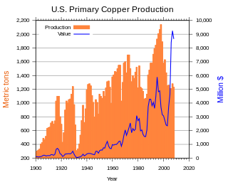
In the United States, copper mining has been a major industry since the rise of the northern Michigan copper district in the 1840s. In 2017, the US produced 1.27 million metric tonnes of copper, worth $8 billion, making it the world's fourth largest copper producer, after Chile, China, and Peru. Copper was produced from 23 mines in the US. Top copper producing states in 2014 were Arizona, Utah, New Mexico, Nevada, and Montana. Minor production also came from Idaho and Missouri. As of 2014, the US had 45 million tonnes of known remaining reserves of copper, the fifth largest known copper reserves in the world, after Chile, Australia, Peru, and Mexico.
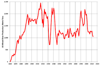
Silver mining in the United States began on a major scale with the discovery of the Comstock Lode in Nevada in 1858. The industry suffered greatly from the demonetization of silver in 1873 by the Coinage Act of 1873, known pejoratively as the "Crime of 73", but silver mining continues today.
Silver mining in Nevada, a state of the United States, began in 1858 with the discovery of the Comstock Lode, the first major silver-mining district in the United States. Nevada calls itself the "Silver State." Nevada is the nation's second-largest producer of silver, after Alaska. In 2014 Nevada produced 10.93 million troy ounces of silver, of which 6.74 million ounces were as a byproduct of the mining of gold. The largest byproducers were the Hycroft Mine, the Phoenix Mine, the Midas Mine and Round Mountain.
Wonder, Nevada, is a ghost town in Churchill County, Nevada, approximately 39 miles (63 km) east of Fallon.
Mount Tenabo is the principal peak in the Cortez Mountains. The mountain is of cultural and religious significance to the Western Shoshone people.
Cortez Gold Mine is a large gold mining and processing facility in Lander and Eureka County, Nevada, United States, located approximately 63 miles (100 km) southwest of Elko. It is owned as a joint venture between Barrick Gold Corporation (61.5%) and Newmont Corporation (38.5%), operated by Barrick, and comprises the Pipeline, Crossroads, and Cortez Hills open pit mines; and the Cortez Hills underground mine. Ore from the mines is treated at an oxide mill at the site and on leach pads, while refractory ore is shipped to Barrick’s Goldstrike operation for processing.
Poeville, also known as Peavine until 1863, is the site of a historical mining town, established in 1864. John Poe, a professional promoter from Michigan allegedly related to Edgar Allan Poe, discovered rich gold and silver veins in 1862 on the slopes of Peavine Mountain. After the discovery of ore, Poe announced that the veins comprised the next Comstock Lode; he presented extracted ore at the state fair of 1864 as rich in content. As a result, the former mining camp, called Poe City (Poeville) or Podunk (Poedunk), grew to 200 people by 1864. Ore production in the mining district and population peaked around 1873-1874 with several hundred people living in town, supported by three hotels and a post office. The post office, named "Poeville", operated between September 1, 1874, and March 24, 1878. As of 2010 the population of the community is 0.
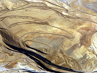
The Round Mountain Gold Mine is an open pit gold mine in Round Mountain, Nevada. The mine is operated and owned by Kinross Gold.
The Ivanhoe is a mining district in Elko County, Nevada, US. It is located in the Butte Creek Range, 10 miles (16 km) southeast of Midas, and 30 miles (48 km) north-northeast of Battle Mountain. It is situated at an elevation of 6,099 feet (1,859 m) above sea level. Mercury mining took place in Ivanhoe between the time of the discovery of cinnabar ore in the 19th century and the mid-1940s. A rare dimorph of cinnabar, metacinnabar, has also been reported in the Ivanhoe district. Gold mining started in the 1980s. The rare mineral, Ammonioalunite, has been discovered in a fossil hot spring deposit in Ivanhoe.
Treasure Hill is an east-jutting spur of the White Pine Range of White Pine County in the east central region of the U.S. state of Nevada. It lies to the east of Mount Hamilton and to the northwest of Mokomoke Hill. It is noted for a silver mining boom in the late 1860s: between 1867 and 1880, the total production from area mines was valued at $20 million. The rush drew thousands to new towns such as Hamilton, situated at the northern base of the hill, and Treasure City, located near its peak, 2.5 miles (4.0 km) from Hamilton.
Cornucopia is an extinct town located in Elko County, Nevada. The town used to be well-known for its mining district area, which was established in 1873. Cornucopia was also known under several names, including Milltown and Kaufmanville.
The epithermal vein deposit (EVP) is a type of mineral deposit that forms in the shallow subsurface, typically at depths of less than 1,500 meters below the Earth's surface. These deposits are formed by hot, mineral-rich fluids that circulate through fractures and cracks in rocks. As the fluids cool, they deposit minerals, such as gold, silver, copper, lead, and zinc, into the veins. EVP are typically small in size, but they can be very high-grade, meaning that they contain a high concentration of valuable minerals.