Eureka, Nevada

Last updated

Eureka, Nevada
2013-09-19 09 56 20 View of downtown Eureka, Nevada.JPG
Nickname: 
The Friendliest Town on The Loneliest Road [1]
USA Nevada location map.svg
Red pog.svg
Eureka
Location in the state of Nevada
Coordinates: 39°30′20″N115°57′52″W / 39.50556°N 115.96444°W / 39.50556; -115.96444
CountryUnited States
State Nevada
County Eureka
Area
[2]
  Total1.29 sq mi (3.35 km2)
  Land1.29 sq mi (3.35 km2)
  Water0.00 sq mi (0.00 km2)
Elevation
[3]
6,674 ft (2,034 m)
Population
 (2020)
  Total414
  Density320.43/sq mi (123.71/km2)
Time zone UTC−8 (Pacific (PST))
  Summer (DST) UTC−7 (PDT)
ZIP code
89316
FIPS code 32-23900
GNIS feature ID2583922 [3]

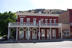
Eureka is an unincorporated town and census-designated place in and the county seat of Eureka County, Nevada, United States. [4] [5] [6] With a population of 414 as of the 2020 United States census, [7] it is the second-largest community in Eureka County. Attractions include the Eureka Opera House (built in 1880 and restored in 1993), Raine’s Market and Wildlife Museum (built 1887), the Jackson House Hotel (built 1877), and the Eureka Sentinel Museum (housed in the 1879 Eureka Sentinel Newspaper Building).

Contents

Eureka is part of the Elko Micropolitan Statistical Area.

Geography and climate

Eureka is located in the southern part of Eureka County, at 6,481 feet (1,975 m) in the Diamond Mountains, in a draw on the southern end of Diamond Valley, between Antelope and Newark valleys. At the 2018 American Community Survey 5-Year Estimates, the population of the census-designated place of Eureka was 480, [7] while the total population of Eureka and the surrounding area (Eureka CCD, Eureka County, Nevada) was 1,313. [8]

The town is located along the Lincoln Highway / U.S. Route 50, nicknamed "The Loneliest Road in America": aptly named, as the nearest towns along the highway are Austin (70 mi or 110 km west) and Ely (77 mi or 124 km east). The nearest town is Duckwater, 46 mi (74 km) south.

The climate is typical of the Great Basin: hot and dry with cool mornings in the summer with occasional monsoonal thunderstorms from late July through August; cold and relatively dry in the winter. Temperatures drop to 0 °F or −17.8 °C or lower on an average 3.2 mornings during the winter, though in the severe winter of 1916/1917 this happened twenty-five times. They drop to 32 °F or 0 °C on an average 185.5 mornings, though maximum temperatures top freezing on all but 30.8 days during an average winter. During the summer temperatures rise to 90 °F or 32.2 °C or hotter on 12.5 afternoons, though 100 °F or 37.8 °C does not occur annually. However, the hottest temperature was 110 °F or 43.3 °C on July 22, 1904. Snow accumulations vary from 10 to 30 inches (0.25 to 0.76 m) in mild winters to in excess of 80 inches (2.03 m) in more severe years; in the winter of 1906/1907, more than 150 inches or 3.81 metres of snow fell.

The wettest calendar year has been 1941 with 23.86 inches (606.0 mm) and the driest 2020 with 4.18 inches (106.2 mm), whilst May 1917 with 5.73 inches (145.5 mm) has been the wettest single month. The snowiest month has been March 1902 with 54.0 inches or 1.37 metres of fresh snowfall.

Under the Köppen climate classification, Eureka has a cold semi-arid (BSk).

Climate data for Eureka, Nevada, 1991–2020 normals, extremes 1888–present
MonthJanFebMarAprMayJunJulAugSepOctNovDecYear
Record high °F (°C)65
(18)
65
(18)
75
(24)
87
(31)
95
(35)
100
(38)
110
(43)
105
(41)
109
(43)
100
(38)
81
(27)
64
(18)
110
(43)
Mean maximum °F (°C)51.3
(10.7)
54.6
(12.6)
64.8
(18.2)
73.1
(22.8)
80.6
(27.0)
88.9
(31.6)
93.6
(34.2)
91.0
(32.8)
85.9
(29.9)
76.9
(24.9)
65.1
(18.4)
53.1
(11.7)
94.2
(34.6)
Mean daily maximum °F (°C)37.6
(3.1)
40.2
(4.6)
48.4
(9.1)
54.9
(12.7)
64.7
(18.2)
76.7
(24.8)
85.6
(29.8)
84.1
(28.9)
74.7
(23.7)
61.7
(16.5)
47.7
(8.7)
37.3
(2.9)
59.5
(15.2)
Daily mean °F (°C)27.8
(−2.3)
29.7
(−1.3)
36.4
(2.4)
41.7
(5.4)
50.6
(10.3)
60.6
(15.9)
69.4
(20.8)
68.2
(20.1)
59.4
(15.2)
47.5
(8.6)
36.0
(2.2)
27.3
(−2.6)
46.2
(7.9)
Mean daily minimum °F (°C)18.0
(−7.8)
19.3
(−7.1)
24.3
(−4.3)
28.6
(−1.9)
36.4
(2.4)
44.4
(6.9)
53.2
(11.8)
52.3
(11.3)
44.1
(6.7)
33.3
(0.7)
24.3
(−4.3)
17.3
(−8.2)
33.0
(0.5)
Mean minimum °F (°C)0.4
(−17.6)
3.3
(−15.9)
10.1
(−12.2)
16.7
(−8.5)
24.5
(−4.2)
32.0
(0.0)
43.8
(6.6)
42.6
(5.9)
31.4
(−0.3)
17.9
(−7.8)
6.8
(−14.0)
0.2
(−17.7)
−4.5
(−20.3)
Record low °F (°C)−26
(−32)
−23
(−31)
−10
(−23)
5
(−15)
10
(−12)
11
(−12)
29
(−2)
30
(−1)
5
(−15)
0
(−18)
−10
(−23)
−21
(−29)
−26
(−32)
Average precipitation inches (mm)0.85
(22)
1.28
(33)
1.34
(34)
1.36
(35)
1.18
(30)
0.49
(12)
0.46
(12)
0.64
(16)
0.78
(20)
0.83
(21)
0.79
(20)
0.86
(22)
10.86
(277)
Average snowfall inches (cm)8.8
(22)
11.9
(30)
7.4
(19)
4.5
(11)
0.8
(2.0)
0.0
(0.0)
0.0
(0.0)
0.0
(0.0)
0.1
(0.25)
0.6
(1.5)
3.4
(8.6)
9.8
(25)
47.3
(119.35)
Average precipitation days (≥ 0.01 in)5.95.95.86.45.42.32.73.13.13.54.66.455.1
Average snowy days (≥ 0.1 in)2.82.41.71.40.50.00.00.00.10.31.53.314.0
Source 1: NOAA [9]
Source 2: National Weather Service [10]

History

The historic Jackson House Hotel, built 1877 JacksonHouseHotelEurekaNV.jpg
The historic Jackson House Hotel, built 1877
The historic Richmond Mine, one of the two major lead-silver mines in Eureka Richmond Mine-Eureka NV.jpg
The historic Richmond Mine, one of the two major lead-silver mines in Eureka

The town was first settled in 1864 by a group of silver prospectors from nearby Austin, who discovered rock containing a silver-lead ore on nearby Prospect Peak. According to tradition, the town was named from an incident when a prospector exclaimed "Eureka!" when he discovered deposits of silver ore. [11] The town became the county seat in 1873, when Eureka County was carved out of adjacent Lander, Elko, and White Pine counties.

Mining, especially for lead, was the town's economic mainstay, [12] as the nearby hillsides ranked as Nevada's second-richest mineral producer, behind western Nevada's Comstock Lode. Two of the largest concerns in Eureka were the Richmond Mining Company and the Eureka Mining Company. These two companies often collided, and in one instance, their litigation reached the U.S Supreme Court. [13] The population boomed, reaching a high of 10,000 by 1878, but shrank as decreasing mine production and changing market conditions led to the closing of mines.

The town was serviced by the narrow gauge Eureka and Palisade Railroad from 1873 to 1938.

Demographics

Historical population
CensusPop.Note
2020 414
U.S. Decennial Census [14]

Public services

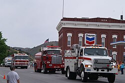
Eureka is served by an all-volunteer fire department, which provides fire protection, rescue, and vehicle rescue services for Eureka and the surrounding areas. In 2009 a new brick and steel fire house was built on Main Street in Eureka. At the time of its building it was the second largest fire house in the state. In addition to being a modern fire fighting facility, it contains a museum of Eureka fire department equipment and vehicles dating back to the 1870s. The fire-museum may be viewed through the large glass windows, or a tour may be taken by contacting a local fireman.

Eureka boasts three parks, a modern enclosed swimming facility, two baseball fields, a track, and football field.

The 1880s Eureka Opera House was re-modeled in recent times and regularly schedules performers. [15]

The 1876 Eureka Court House is both historic and modern. It stands as the functioning governmental and legal center of Eureka County.

Education

Eureka County School District is the local school district.

Eureka has a public library, a branch of the Elko-Lander-Eureka County Library System. [16]

Transportation

Notable people

Related Research Articles

<span class="mw-page-title-main">Carson City, Nevada</span> State capital of Nevada, United States

Carson City is an independent city and the capital of the U.S. state of Nevada. As of the 2020 census, the population was 58,639, making it the 6th most populous city in the state. The majority of the city's population lives in Eagle Valley, on the eastern edge of the Carson Range, a branch of the Sierra Nevada, about 30 miles (50 km) south of Reno. The city is named after the mountain man Kit Carson. The town began as a stopover for California-bound immigrants, but developed into a city with the Comstock Lode, a silver strike in the mountains to the northeast. The city has served as Nevada's capital since statehood in 1864; for much of its history it was a hub for the Virginia and Truckee Railroad, although the tracks were removed in 1950.

<span class="mw-page-title-main">Weaverville, California</span> Census-designated place in California, United States

Weaverville is a census-designated place and the county seat of Trinity County, California, United States. Its population is 3,667 as of the 2020 census, up from 3,600 from the 2010 census.

<span class="mw-page-title-main">Minden, Nevada</span> County seat in Nevada, United States

Minden is a census-designated place (CDP) in Douglas County, Nevada, United States. The population was 3,001 at the 2010 census. It is the county seat of Douglas County and is adjacent to the town of Gardnerville. The Douglas campus of the Western Nevada College is located in Minden.

<span class="mw-page-title-main">Elko, Nevada</span> City in Nevada, United States

Elko is a city in the U.S. state of Nevada and the county seat of Elko County. As of the official 2020 U.S. Census, the city has a population of 20,564. Elko serves as the center of the Ruby Valley, a region with a population of over 55,000. Elko is 21 miles (34 km) from Lamoille Canyon and the Ruby Mountains, providing year-round access to recreation, including hiking, skiing, hunting, and more than 20 alpine lakes. The city straddles the Humboldt River. Spring Creek, Nevada, serves as a bedroom community 6 miles (10 km) from the city with a population of 13,805.

<span class="mw-page-title-main">Battle Mountain, Nevada</span> Unincorporated town in the State of Nevada, United States

Battle Mountain is an unincorporated town in and the county seat of Lander County, Nevada, United States. The population was 3,705 at the 2020 census. Its primary economic base is gold mining and, to a lesser extent, legalized gambling.

<span class="mw-page-title-main">Yerington, Nevada</span> City in Nevada, United States

Yerington is a city in Lyon County, Nevada, United States. The population was 3,048 at the 2010 census. It is the current county seat of Lyon County, with the first county seat having been established at Dayton on November 29, 1861. It is named after Henry M. Yerington, superintendent of the Virginia and Truckee Railroad from 1868 to 1910.

<span class="mw-page-title-main">Tonopah, Nevada</span> Unincorporated town in the state of Nevada, United States

Tonopah is an unincorporated town in and the county seat of Nye County, Nevada, United States. Nicknamed the Queen of the Silver Camps for its mining-rich history, it is now primarily a tourism-based resort city, notable for attractions like the Mizpah Hotel and the Clown Motel.

<span class="mw-page-title-main">Ely, Nevada</span> City in Nevada, United States

Ely is the largest city and county seat of White Pine County, Nevada, United States. Ely was founded as a stagecoach station along the Pony Express and Central Overland Route. In 1906 copper was discovered. Ely's mining boom came later than the other towns along US 50. The railroads connecting the transcontinental railroad to the mines in Austin, Nevada and Eureka, Nevada have long been removed, but the railroad to Ely is preserved as a heritage railway by the Nevada Northern Railway and known as the Ghost Train of Old Ely. As of the 2020 census, the population was 3,924.

<span class="mw-page-title-main">Grants, New Mexico</span> City in New Mexico, United States

Grants is a city in Cibola County, New Mexico, United States. It is located about 78 miles (126 km) west of Albuquerque. The population was 9,163 at the 2020 Census. It is the county seat of Cibola County.

<span class="mw-page-title-main">Riddle, Oregon</span> City in Oregon, United States

Riddle is a city in Douglas County, Oregon, United States. The population was 1,185 at the 2010 census.

<span class="mw-page-title-main">Lead, South Dakota</span> City in South Dakota, United States

Lead is a city in Lawrence County, South Dakota, United States. The population was 2,982 at the 2020 census. Lead is located in western South Dakota, in the Black Hills near the Wyoming state line.

<span class="mw-page-title-main">Hebbronville, Texas</span> Census-designated place in Jim Hogg County, Texas, United States

Hebbronville is a census-designated place (CDP) in and the county seat of Jim Hogg County, Texas, United States. The population was 4,101 at the 2020 census.

<span class="mw-page-title-main">Bridgeport, California</span> Census designated place and county seat in California, United States

Bridgeport is an unincorporated community and census-designated place (CDP) in Mono County, California, United States. It is the Mono county seat. The population was 553 at the 2020 census.

<span class="mw-page-title-main">Bodie, California</span> Ghost town in Mono County

Bodie is a ghost town in the Bodie Hills east of the Sierra Nevada mountain range in Mono County, California, United States. It is about 75 miles (121 km) southeast of Lake Tahoe, and 12 mi (19 km) east-southeast of Bridgeport, at an elevation of 8,379 feet (2554 m). Bodie became a boom town in 1876 after the discovery of a profitable vein of gold; by 1879 it had established 2,000 structures with a population of roughly 8,000 people.

<span class="mw-page-title-main">Goldfield, Nevada</span> Place in Esmeralda County, Nevada

Goldfield is a census-designated place in and the county seat of Esmeralda County, Nevada.

<span class="mw-page-title-main">Pioche, Nevada</span> Unincorporated town in the State of Nevada, United States

Pioche is an unincorporated town in Lincoln County, Nevada, United States, approximately 180 miles (290 km) northeast of Las Vegas. U.S. Route 93 is the main route to Pioche and bypasses the town center just to the east, with Nevada State Route 321 and Nevada State Route 322 providing direct access. Pioche is the county seat of Lincoln County. Pioche is named after François Louis Alfred Pioche, a San Francisco financier and land speculator originally from France. The town's population was 1,002 at the 2010 census.

<span class="mw-page-title-main">Austin, Nevada</span> Unincorporated town in the State of Nevada, United States

Austin is an unincorporated small town in, and former county seat of, Lander County, Nevada, United States. In 2020, the census-designated place of Austin had a population of 167. It is located on the western slopes of the Toiyabe Range at an elevation of 6,575 feet (2,004 m). U.S. Route 50 passes through the town.

<span class="mw-page-title-main">Cherry Creek, Nevada</span> Historic mining town in Nevada, U.S.

Cherry Creek is a historic mining town located in northern White Pine County, in northeastern Nevada in the western United States. It is a census county division (CCD), with a population at the 2010 census of 72.

<span class="mw-page-title-main">Graniteville, California</span> Unincorporated community in California, United States

Graniteville is a small, unincorporated community and census-designated place (CDP) located in Nevada County, California, United States. The town sits on the San Juan ridge separating the Middle and South Forks of the Yuba River, approximately 26 miles (42 km) northeast of Nevada City. The elevation of Graniteville is 4,977 feet (1,517 m) above sea level. As of the 2010 census, Graniteville had a population of 11.

<span class="mw-page-title-main">Swansboro, California</span> Unincorporated community in California, United States

Swansboro Country; a subdivision within the community of Mosquito, is a residential area northeast of Placerville, the county seat of El Dorado County, California. The population was approximately 1,000 at the 2010 census. It is part of the Sacramento–Arden-Arcade–Roseville Metropolitan Statistical Area.

References

  1. "The Loneliest Road In America Comes Of Age – Nevada Magazine". Nevada Magazine –. January 11, 2016. Retrieved August 27, 2022.
  2. "ArcGIS REST Services Directory". United States Census Bureau. Retrieved September 19, 2022.
  3. 1 2 U.S. Geological Survey Geographic Names Information System: Eureka, Nevada
  4. "Eureka County Code - Title 12- Town of Eureka" (PDF). Eureka County. Retrieved October 16, 2017.
  5. "Find a County". National Association of Counties. Archived from the original on May 31, 2011. Retrieved June 7, 2011.
  6. Lambert Molinelli & Co (1982). Eureka and its resources: a complete history of Eureka County, Nevada, containing the United States mining laws, the mining laws of the district, bullion product and other statistics for 1878, and a list of county officers. Reno, Nev.: University of Nevada Press. ISBN   978-0-87417-069-6. LCCN   82004948. OCLC   8346713. Reprint. Originally published: San Francisco : H. Keller, 1879.
  7. 1 2 "Census Geography Profile". U.S. Census Bureau. Retrieved March 11, 2024.
  8. "Census Search result". U.S. Census Bureau. Retrieved April 10, 2020.
  9. "U.S. Climate Normals Quick Access". National Oceanic and Atmospheric Administration. Retrieved September 13, 2022.
  10. "NOAA Online Weather Data". National Weather Service. Retrieved September 13, 2022.
  11. Federal Writers' Project (1941). Origin of Place Names: Nevada (PDF). W.P.A. p. 34.
  12. "Eureka, Nevada". Western Mining History. Retrieved March 18, 2012.
  13. "Richmond Mining Co. v. Eureka Mining Co., 103 U.S. 839 (1880)". Justia Law. Retrieved September 9, 2021.
  14. "Census of Population and Housing". Census.gov. Retrieved June 4, 2016.
  15. "Eureka Opera House". Eureka County, Nevada -- Official Home Page. Retrieved March 18, 2012.
  16. "Nevada Public Libraries". PublicLibraries.com. Retrieved June 14, 2019.
  17. Biographical Directory of the United States Congress