Inyo County is a county in the eastern central part of the U.S. state of California, located between the Sierra Nevada and the state of Nevada. In the 2020 census, the population was 19,016. The county seat is Independence. Inyo County is on the east side of the Sierra Nevada and southeast of Yosemite National Park in Central California. It contains the Owens River Valley; it is flanked to the west by the Sierra Nevada and to the east by the White Mountains and the Inyo Mountains. With an area of 10,192 square miles (26,400 km2), Inyo is the second-largest county by area in California, after San Bernardino County. Almost one-half of that area is within Death Valley National Park. However, with a population density of 1.8 people per square mile, it also has the second-lowest population density in California, after Alpine County.

The Wasatch Range or Wasatch Mountains is a mountain range in the western United States that runs about 160 miles (260 km) from the Utah-Idaho border south to central Utah. It is the western edge of the greater Rocky Mountains, and the eastern edge of the Great Basin region. The northern extension of the Wasatch Range, the Bear River Mountains, extends just into Idaho, constituting all of the Wasatch Range in that state.

The San Jacinto Mountains are a mountain range in Riverside County, located east of Los Angeles in southern California in the United States. The mountains are named for one of the first Black Friars, Saint Hyacinth, who is a popular patron in Latin America.
The Desatoya Mountains are located in central Nevada in the western United States, approximately 117 miles east of Reno by road. The range runs in a southwest-northeasterly direction along the border of Churchill and Lander counties, reaching a maximum elevation of 9,978 feet (3,041 m) at Desatoya Peak near Rock Creek Canyon.

State Route 278 is a state highway in Nevada. It runs from U.S. Route 50 near Eureka north to Interstate 80 (I-80) in Carlin.
The Jackson Mountains are a north-northeast trending mountain range in southwestern Humboldt County, Nevada. The range is flanked on the west by the Black Rock Desert and the Black Rock Range beyond. To the north across the Quinn River and Nevada State Route 140 lie the Bilk Creek Mountains. To the northeast across Kings River Valley is the Double Mountains and to the east are the Sleeping Hills. To the southeast and south lie the Eugene and Kamma Mountains. The ghost town of Sulphur lies just southwest of the pass between the Jackson and Kamma ranges. Nevada State Route 49 and the Union Pacific railroad Feather River Route traverse this pass.

Union Pass is a high mountain pass in the Wind River Range in Fremont County of western Wyoming in the United States. The pass is located on the Continental Divide between the Gros Ventre mountains on the west and the Wind River Range on the east. A triple divide exists nearby, where water may flow to the Mississippi River, Columbia River, or Colorado River. The pass was historically used by Native Americans and early mountain men including the Astor Expedition in 1811 on its way west. On the return trip, fearing hostile Indian activity near Union Pass, the Astorians chose a southern route and discovered South Pass.
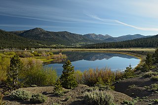
The Piper Mountain Wilderness is a federally designated wilderness area located in the White Mountains 20 miles (32 km) northeast of Big Pine, California in Inyo County, California.

The Seaman Range is a 30-mile (48 km) long mountain range in Lincoln and Nye counties, Nevada, in the western United States.
The Harcuvar Mountains are a narrow mountain range in western-central Arizona, United States. The range lies just east of the north–south Colorado River, and south of the east–west, west-flowing Bill Williams River, from Alamo Lake.

The Mohave Mountains are a small 18-mi (29 km) long mountain range of northwest Arizona. The range is a northwest trending range in southwest Mohave County that parallels a southeast-flowing stretch of the Colorado River, the Arizona-California border. The range also forms the southwest border of a flatland region to its east and north, namely, Dutch Flat which lies east, at the south end of Sacramento Valley. Lake Havasu City, AZ on the Colorado, lays opposite the southwest flank of the range, where the London Bridge was reconstructed at Lake Havasu.
The Antelope Valley of west Lander County is a small, 25 mile long, mostly arid valley in central Nevada, USA. A fourth valley of the same name Antelope Valley lies in southern Eureka County, east of the Monitor Range. The Lander County valley lies south of the Humboldt River and with Antelope Creek, is a western tributary valley to the north-flowing Reese River.

The Cedar Mountains of Tooele County, Utah, USA, are a 45-mile (72 km) long mountain range located in the county's east, bordering east sections of the Great Salt Lake Desert on the range's west and southwest flanks.

The Gilson Mountains are an 11-mile (18 km) long almost circular, small mountain range adjacent the north terminus of the Canyon Mountains,, located in far eastern Juab County, Utah, United States.
The Dugway Range is a 13-mile (21 km) long mountain range located in central-south Tooele County, Utah, on the Juab County north border.

Pine Valley is a 50-mile (80 km) long valley in southwestern Utah, United States. Most of the valley lies in western Beaver and Millard counties; the extreme south of the valley arises in two mountain range regions in northwestern Iron County.

The Red Mountains of Washington County, Utah, United States, is a mostly circular 7 miles (11 km) long mountain range.

Beaver Lake Mountains is an 8-mile (13 km) long mountain in central and north Beaver County, Utah, United States adjacent the south border of Millard County.

The Bitter Spring Valley is a 13-mile (21 km) long valley located northeast of Las Vegas, Nevada on the west edge of Lake Mead, on the north-trending Overton Arm,.