
Shelby County Airport is a public use airport located four nautical miles (7 km) southeast of the central business district of Alabaster, a city in Shelby County, Alabama, United States. It is owned by the Shelby County Commission. The airport is situated in the city of Calera.
Clarion Municipal Airport is a city-owned public-use airport located one nautical mile (1.85 km) northwest of the central business district of Clarion, a city in Wright County, Iowa, United States. This airport is included in the FAA's National Plan of Integrated Airport Systems for 2009–2013, which categorized it as a general aviation facility.
Springdale Municipal Airport is a public use airport in Washington County, Arkansas, United States. It is owned by the City of Springdale and located one nautical mile (2 km) southeast of its central business district. This airport is included in the National Plan of Integrated Airport Systems for 2011–2015, which categorized it as a general aviation facility.

Henderson Executive Airport is a public use government airport located in Henderson, Nevada, 13 miles south of Las Vegas, in Clark County, Nevada. The airport is owned by the Clark County Commission and operated by the Clark County Department of Aviation. The FAA's National Plan of Integrated Airport Systems for 2009-2013 categorized it as a reliever airport.
Jackpot Airport, also known as Hayden Field, is a county-owned, public-use airport located east of Jackpot, in Elko County, Nevada, United States. The National Plan of Integrated Airport Systems for 2011–2015 categorized it as a general aviation facility.

Boulder City Municipal Airport is a public use airport located one nautical mile (2 km) southwest of the central business district of Boulder City, in Clark County, Nevada, United States. In operation since 1990, it is owned by Boulder City Municipality.

Derby Field is a public airport nine miles southwest of Lovelock, in Pershing County, Nevada. The National Plan of Integrated Airport Systems for 2011–2015 categorized it as a general aviation facility.

Grant County Regional Airport - GCRA is in Grant County, Oregon, a mile southwest of John Day, Oregon. The National Plan of Integrated Airport Systems for 2011–2015 categorized it as a general aviation facility.
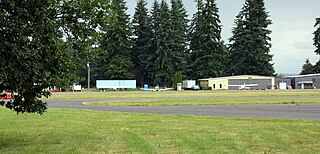
Scappoose Airport is a public use airport located one nautical mile (1.85 km) northeast of the central business district of Scappoose, in Columbia County, Oregon, United States. It is owned and operated by the Port of Columbia County, an Oregon port district and municipal corporation, on behalf of district residents. According to the FAA's National Plan of Integrated Airport Systems for 2009–2013, it is categorized as a general aviation airport.

Tillamook Airport is a public use airport located 3 miles (4.8 km) south of the central business district of Tillamook, a city in Tillamook County, Oregon, United States. It is owned by the Port of Tillamook Bay. According to the FAA's National Plan of Integrated Airport Systems for 2009–2013, it is categorized as a general aviation facility.

Sylacauga Municipal Airport, also known as Merkel Field, is a city-owned public-use airport located three nautical miles west of the central business district of Sylacauga, a city in Talladega County, Alabama, United States. It is included in the FAA's National Plan of Integrated Airport Systems for 2011–2015, which categorized it as a general aviation facility.

Murfreesboro Municipal Airport is a city-owned, public-use airport located two nautical miles (3.7 km) north of the central business district of Murfreesboro, a city in Rutherford County, Tennessee, United States. This airport is included in the National Plan of Integrated Airport Systems for 2011–2015, which categorized it as a general aviation airport. Although most U.S. airports use the same three-letter location identifier for the FAA and IATA, this airport is assigned MBT by the FAA, but has no designation from the IATA.
Centerville Municipal Airport is a city-owned public-use airport located three nautical miles (6 km) southwest of the central business district of Centerville, a city in Appanoose County, Iowa, United States. According to the FAA's National Plan of Integrated Airport Systems for 2009–2013, it is categorized as a general aviation airport.
Russellville Regional Airport is a city-owned public-use airport located two nautical miles (3.7 km) southeast of the central business district of Russellville, a city in Pope County, Arkansas, United States. According to the FAA's National Plan of Integrated Airport Systems for 2009–2013, it is categorized as a general aviation facility. It was formerly known as Russellville Municipal Airport.
J. Lynn Helms Sevier County Airport is a county-owned public-use airport in Sevier County, Arkansas, United States. It is located three nautical miles west of the central business district of De Queen, Arkansas. The airport is named for J. Lynn Helms, who was Administrator of the Federal Aviation Administration under U.S. President Ronald Reagan. Helms was born in De Queen.

Sharp County Regional Airport is a public-use airport in Sharp County, Arkansas, United States. It is located three nautical miles northeast of the central business district of Ash Flat, Arkansas. The airport is owned by the Sharp County Regional Airport Authority.
Choteau Airport is a public use airport located one nautical mile (2 km) northeast of the central business district of Choteau, a city in Teton County, Montana, United States. The airport is owned by the city and county. It is included in the National Plan of Integrated Airport Systems for 2011–2015, which categorized it as a general aviation airport.
Portland Municipal Airport is a city-owned, public-use airport located one nautical mile (2 km) northwest of the central business district of Portland, a city in Jay County, Indiana, United States. It is included in the National Plan of Integrated Airport Systems for 2011–2015, which categorized it as a general aviation facility.
New Castle-Henry County Municipal Airport is a public use airport located four nautical miles southeast of the central business district of New Castle, a city in Henry County, Indiana, United States. It is included in the National Plan of Integrated Airport Systems for 2011–2015, which categorized it as a general aviation facility.
White County Airport is a public use airport in White County, Indiana, United States. It is owned by the White County Board of Aviation Commissioners and located three nautical miles (6 km) south of the central business district of Monticello, Indiana. This airport is included in the National Plan of Integrated Airport Systems for 2011–2015, which categorized it as a general aviation facility.

