Spring Creek, Nevada

Last updated

Spring Creek, Nevada
CDP
2014-06-13 12 25 37 View of Spring Creek, Nevada from the summit of "E" Mountain in the Elko Hills of Nevada.JPG
View of Spring Creek from "E" Mountain, with the Ruby Mountains in the background
Elko County Nevada Incorporated and Unincorporated areas Spring Creek Highlighted.svg
Location of Spring Creek within Nevada
Coordinates: 40°44′48″N115°35′34″W / 40.74667°N 115.59278°W / 40.74667; -115.59278
CountryUnited States
State Nevada
County Elko
Area
[1]
  Total53.73 sq mi (139.17 km2)
  Land53.67 sq mi (138.99 km2)
  Water0.07 sq mi (0.17 km2)
Elevation
5,659 ft (1,725 m)
Population
 (2020)
  Total14,967
  Density278.89/sq mi (107.68/km2)
Time zone UTC−8 (Pacific (PST))
  Summer (DST) UTC−7 (PDT)
ZIP code
89815
Area code 775
FIPS code 32-68550
GNIS feature ID0857655

Spring Creek is a census-designated place (CDP) in central Elko County, in northeastern Nevada in the western United States. It mainly serves as a bedroom community for the businesses and industries in and around the nearby city of Elko. It is part of the Elko Micropolitan Statistical Area. The population was 12,361 at the 2010 census.

Contents

Geography

Spring Creek is located in a large valley between the Elko Hills [2] to the northwest, and the Ruby Mountains [3] to the southeast. To the southwest is Huntington Valley and the South Fork of the Humboldt River, while to the north is the main branch of the Humboldt. The city of Elko is approximately 6 miles (9.7 km) to the northwest, while Lamoille is just to the east. According to the United States Census Bureau, the CDP has a total area of 58.7 square miles (152 km2).

Marina Park in Spring Creek, Nevada SpringCreekMarina2.jpg
Marina Park in Spring Creek, Nevada
Spring Creek lies at the base of the Ruby Mountains SpringCreekNV.jpg
Spring Creek lies at the base of the Ruby Mountains
Spring Creek High School Spring Creek High.jpg
Spring Creek High School
Spring Creek from Lamoille Summit Spring Creek.jpg
Spring Creek from Lamoille Summit

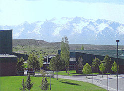
The community was developed in the 1970s by C. V. Wood, president of McCulloch Oil, as three large housing sections. [4] The western section, at the base of the Elko Hills, is located near the post office (zip 89815), a shopping center, and a supermarket. About 1 mile to the east is the main school campus for grades 1-12. The central section of the community, another mile to the east, includes a park and lake ("The Marina"), and an 18-hole golf course and clubhouse. Nearby are an outdoor sports complex and a second elementary school. The southern section of the community surrounds an indoor sports arena ("The Horse Palace"), and is adjacent to the Ruby Mountains and a community-owned campground.

Demographics

Historical population
CensusPop.Note
1990 5,866
2000 10,54879.8%
2010 12,36117.2%
2020 14,96721.1%
source: [5]

As of the census [6] of 2010, there were 12,362 people, 4,204 households, and 3,425 families residing in the CDP. The population density was 179.8 inhabitants per square mile (69.4/km2). There were 4,394 housing units at an average density of 62.4 per square mile (24.1/km2). The racial makeup of the CDP was 92.5% White, 0.3% African American, 1.6% Native American, 0.6% Asian, 0.1% Pacific Islander, 2.3% from other races, and 2.6% from two or more races. Hispanic or Latino of any race were 7.8% of the population.

Spring Creek Association Executive Offices 2014-07-26 09 46 07 Spring Creek Homeowners Association Executive Offices in Spring Creek, Nevada.JPG
Spring Creek Association Executive Offices

There were 4,204 households, out of which 44.1% had children under the age of 18 living with them, 75.2% were married couples living together, 4.7% had a female householder with no husband present, and 15.0% were non-families. 11.0% of all households were made up of individuals, and 1.6% had someone living alone who was 65 years of age or older. The average household size was 3.10 and the average family size was 3.35.

In the CDP, the population was spread out, with 35.1% under the age of 18, 6.0% from 18 to 24, 33.5% from 25 to 44, 22.1% from 45 to 64, and 3.2% who were 65 years of age or older. The median age was 32 years. For every 100 females, there were 105.0 males. For every 100 females age 18 and over, there were 104.9 males.

The median income for a household in the CDP was $60,109, and the median income for a family was $61,650. Males had a median income of $50,053 versus $27,260 for females. The per capita income for the CDP was $20,606. About 2.9% of families and 4.2% of the population were below the poverty line, including 2.7% of those under age 18 and 8.2% of those age 65 or over.

Transportation

SR 227, more commonly known as Lamoille Highway, is the primary highway through Spring Creek, connecting it to Lamoille and Elko. SR 228, also known as Jiggs Highway, begins at SR 227 in Spring Creek and continues south to Jiggs; the road eventually reaches Ruby Valley after losing its state highway designation. Passenger rail service is available from the nearby Elko Train Station, while commercial air service can be found at the Elko Regional Airport.

Media

Related Research Articles

<span class="mw-page-title-main">Willow Street, Pennsylvania</span> Census-designated place in Pennsylvania, United States

Willow Street is an unincorporated community and census-designated place (CDP) in Lancaster County, Pennsylvania, United States. The population was 7,578 at the 2010 census. In the early part of the 20th century, the main thoroughfare in town was lined with willow trees on both sides for the length of the town, hence the community's name. As time passed and the town grew, the road was widened and sidewalks were installed, which required the trees be removed. Only a few of the original trees remain to this day.

<span class="mw-page-title-main">Elko County, Nevada</span> County in Nevada, United States

Elko County is a county in the northeastern corner of Nevada, United States. As of the 2020 census, the population was 53,702. Its county seat is Elko. The county was established on March 5, 1869, from Lander County.

<span class="mw-page-title-main">Brickerville, Pennsylvania</span> Census-designated place in Pennsylvania, United States

Brickerville is an unincorporated community and census-designated place (CDP) in Elizabeth Township, Lancaster County, Pennsylvania, United States, with a ZIP code of 17543. The population was 1,309 at the 2010 census.

<span class="mw-page-title-main">Primrose, Alaska</span> Census-designated place in Alaska, United States

Primrose is a census-designated place (CDP) in Kenai Peninsula Borough, Alaska, United States. The population was 78 at the 2010 census, down from 93 at the 2000 census. Primrose is one of a number of small communities located north of Seward along the Seward Highway.

<span class="mw-page-title-main">Trapper Creek, Alaska</span> Census-designated place in Alaska, United States

Trapper Creek is a census-designated place (CDP) in Matanuska-Susitna Borough, Alaska, United States. It is part of the Anchorage Metropolitan Area and is known as the southern gateway to Denali State Park. According to the 2020 census the population of Trapper Creek was 499.

<span class="mw-page-title-main">Prairie Creek, Arkansas</span> CDP in Arkansas, United States

Prairie Creek is a census-designated place (CDP) in Benton County, Arkansas, United States. Per the 2020 census, the population was 2,217. It is a lakefront community adjacent to Beaver Lake and Rogers within the Northwest Arkansas region.

<span class="mw-page-title-main">High Ridge, Missouri</span> Census-designated place in Missouri, United States

High Ridge is an unincorporated community and census-designated place (CDP) in Jefferson County, Missouri, United States. The population was 4,305 at the 2010 census. At 927 feet (283 m) above sea level, High Ridge is the second-highest point in Jefferson County, second only to Sun Ridge, north of Hillsboro, according to data from the House Springs/Hillsboro 7.5 minute topographic quadrangles. The Beaumont Scout Reservation, a property of the Greater St. Louis Area Council, Boy Scouts of America, is 4 miles (6 km) north of High Ridge.

<span class="mw-page-title-main">Alder, Montana</span> Census-designated place in Montana, United States

Alder is a census-designated place (CDP) in Madison County, Montana, United States. The population was 86 at the 2020 census. The community takes its name from Alder Creek, the site of the second major gold discovery in Montana.

<span class="mw-page-title-main">Elko, Nevada</span> City in Nevada, United States

Elko is the largest city in and county seat of Elko County, Nevada, United States. With a 2020 population of 20,564, Elko is currently growing at a rate of 0.31% annually and its population has increased by 11.86% since the 2010 Census, which recorded a population of 18,297. Elko serves as the economic hub of the Ruby Valley, a region with a population of over 55,000. Elko is 21 miles (34 km) from Lamoille Canyon and the Ruby Mountains, dubbed the Swiss Alps of Nevada, providing year round access to recreation including hiking, skiing, hunting, and more than 20 alpine lakes. The city straddles the Humboldt River. Most of the residents in Elko live within the Tree Streets, houses lined with trees and greenery. Spring Creek, Nevada, serves as a bedroom community 6 miles (9.7 km) from the city with a population of 13,805.

<span class="mw-page-title-main">Vancleave, Mississippi</span> Census-designated place in Mississippi

Vancleave is an unincorporated community and census-designated place (CDP) in Jackson County, Mississippi, United States. It is part of the Pascagoula Metropolitan Statistical Area. The population was 5,886 at the 2010 census, up from 4,910 at the 2000 census.

<span class="mw-page-title-main">Avery Creek, North Carolina</span> Census-designated place in North Carolina, United States

Avery Creek is a census-designated place (CDP) in Buncombe County, North Carolina, United States. The population was 1,950 at the 2010 census. It is part of the Asheville Metropolitan Statistical Area.

<span class="mw-page-title-main">Dry Creek, Oklahoma</span> Census-designated place in Oklahoma, United States

Dry Creek is an unincorporated community and census-designated place (CDP) in Cherokee County, Oklahoma, United States. The population was 227 at the 2010 census.

<span class="mw-page-title-main">Houserville, Pennsylvania</span> Census-designated place in Pennsylvania, United States

Houserville is an unincorporated community and census-designated place (CDP) in Centre County, Pennsylvania, United States. It is part of the State College, Pennsylvania Metropolitan Statistical Area. The population was 1,814 at the 2010 census.

<span class="mw-page-title-main">Spring Mills, Pennsylvania</span> Census designated place in Pennsylvania, United States

Spring Mills is an unincorporated community and census-designated place (CDP) in Centre County, Pennsylvania, United States. It is part of the State College, Pennsylvania Metropolitan Statistical Area. The population was 268 at the 2010 census.

Springdale is an unincorporated community and census-designated place (CDP) in Lancaster County, South Carolina, United States. The population was 2,574 at the 2010 census, down from 2,864 at the 2000 census.

<span class="mw-page-title-main">Mountville, South Carolina</span> Census-designated place in South Carolina, United States

Mountville is an unincorporated community and census-designated place (CDP) in Laurens County, South Carolina, United States. The population was 108 at the 2010 census, down from 130 at the 2000 census. It is part of the Greenville–Mauldin–Easley Metropolitan Statistical Area.

<span class="mw-page-title-main">Red Bank, South Carolina</span> Census-designated place in South Carolina, United States

Red Bank is an unincorporated community and census-designated place (CDP) in Lexington County, South Carolina, United States. The population was 9,617 at the 2010 census, up from 8,811 at the 2000 census. It is part of the Columbia, South Carolina Metropolitan Statistical Area.

<span class="mw-page-title-main">Lipscomb, Texas</span> Census-designated place in Texas, United States

Lipscomb is an unincorporated community and census-designated place (CDP) in Lipscomb County, Texas, United States. It is the Lipscomb county seat. The population was 37 at the 2010 census.

<span class="mw-page-title-main">Montezuma Creek, Utah</span> Census-designated place in Utah, United States

Montezuma Creek is a census-designated place (CDP) in San Juan County, Utah, United States. The population was 335 at the 2010 census, a decrease from the 2000 figure of 507.

<span class="mw-page-title-main">Nevada State Route 228</span>

State Route 228 (SR 228), also known as Jiggs Highway, is a 20.803-mile (33.479 km) state highway in Elko County, Nevada, United States, that connects Jiggs with Nevada State Route 227 in Spring Creek.

References

  1. "ArcGIS REST Services Directory". United States Census Bureau. Retrieved September 19, 2022.
  2. "Elko Hills". Geographic Names Information System . United States Geological Survey, United States Department of the Interior . Retrieved May 3, 2009.
  3. "Ruby Mountains". Geographic Names Information System . United States Geological Survey, United States Department of the Interior . Retrieved May 3, 2009.
  4. "History of MAXXAM Inc. – FundingUniverse" . Retrieved July 17, 2016.
  5. "CENSUS OF POPULATION AND HOUSING (1790-2000)". U.S. Census Bureau . Retrieved July 17, 2010.
  6. "U.S. Census website". United States Census Bureau . Retrieved January 31, 2008.

40°44′48″N115°35′34″W / 40.746595°N 115.592761°W / 40.746595; -115.592761