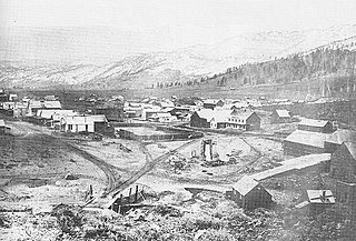
Old Washoe City is a ghost town in Washoe County, Nevada, in the United States. Nearby there is a new community called New Washoe City.
Cobre is a ghost town in Elko County, Nevada, United States.
Blair, Nevada is a mining ghost town in Esmeralda County, Nevada.
Elgin is a ghost town located between Caliente and Carp, Nevada on the eastern banks of the Meadow Valley Wash off of Nevada State Route 317.

Wonder, Nevada, is a ghost town in Churchill County, Nevada, approximately 39 miles (63 km) east of Fallon.

Candelaria is a ghost town in Mineral County, Nevada. Today the site of Candelaria is dominated by the Kinross Gold Candelaria Mine on Mt. Diablo.
Barclay is a town in Lincoln County, Nevada, United States. Originally a Mormon settlement in the late 1860s, it has few residents and appears on several ghost town lists. The Barclay post office closed in 1910. Main sites in the town include an old Mormon cemetery, and an abandoned Post Office, the latter being one of the few remaining buildings in the town.

Bonnie Claire is a ghost town located in Nye County, Nevada. The settlement is located on the edge of Sarcobatus Flat adjacent to Nevada State Route 267. The mines of Slate Ridge lie to the northwest and the northernmost spur of the Amargosa Range, the Grapevine Mountains, is just to the south of the townsite. Bonnie Claire Flat extends to the southwest between the Slate Ridge and the Grapevines to the California border.

Carrara is a ghost town in Nye County, Nevada. The townsite is located in the Amargosa Desert adjacent to US Route 95 about 8.5 miles southeast of Beatty. The old Tonopah and Tidewater Railroad line was about one half mile to the southwest. An old road, previously a railroad grade, runs straight for about 3 miles to the northeast up Carrara Canyon on the southeast flank of the Bare Mountains to an old marble quarry. The quarry is about 1400 feet higher in elevation than the townsite.

Palmetto, Nevada is a ghost town in Esmeralda County, in the U.S. state of Nevada.
Schellbourne, formerly known as Fort Schellbourne and Schell Creek Station is a ghost town located in the Schell Creek Range in White Pine County in Nevada, United States, located 43 miles (69 km) north of Ely. The town was a stopover along the Central Overland Route, Pony Express and original routing of the Lincoln Highway. It is today Nevada Historical Marker number 51. The site was listed on the National Register of Historic Places in 1972. Its boundaries were increased in 1977.
Rowland is a ghost town in northern Elko County, Nevada, United States.

Shafter is a ghost town in Elko County, Nevada, United States.
South Fork is an unincorporated community semi-ghost town in Elko County, Nevada in the United States.

Fairview is a ghost town in Churchill County, Nevada, in the United States of America.

Argenta is a ghost town in Lander County, Nevada, in the United States.
Lander is a ghost town in Lander County in Nevada in the United States. The site is approximately 24 miles southeast of Battle Mountain.
Allred is a ghost town situated in Nye County, Nevada. A post office in the settlement opened on April 17, 1911 with Allen Oxborrow and George Kump as postmasters. The post office was closed more than a year later on October 31, 1912. There are no visible remains left of Allred.
Adaven is a former mining settlement and ghost town in Nye County, Nevada.
This page is based on this
Wikipedia article Text is available under the
CC BY-SA 4.0 license; additional terms may apply.
Images, videos and audio are available under their respective licenses.


