The First Transcontinental Railroad was a 1,912-mile (3,077 km) continuous railroad line constructed between 1863 and 1869 that connected the existing eastern U.S. rail network at Council Bluffs, Iowa with the Pacific coast at the Oakland Long Wharf on San Francisco Bay. The rail line was built by three private companies over public lands provided by extensive US land grants. Construction was financed by both state and US government subsidy bonds as well as by company issued mortgage bonds. The Western Pacific Railroad Company built 132 mi (212 km) of track from the road's western terminus at Alameda/Oakland to Sacramento, California. The Central Pacific Railroad Company of California (CPRR) constructed 690 mi (1,110 km) eastward from Sacramento to Promontory Summit, Utah Territory. The Union Pacific Railroad (UPRR) built 1,085 mi (1,746 km) from the road's eastern terminus at the Missouri River settlements of Council Bluffs and Omaha, Nebraska westward to Promontory Summit.

Palisade is located in Eureka County in the northeastern section of the state of Nevada, in the western United States. It is about 10 miles (16 km) south of Carlin, and about 33 miles (53 km) southwest of Elko. Although now a virtual ghost town, it had a rich history following construction of the Transcontinental Railroad. The town takes its name from Palisade Canyon, an important obstacle to the construction and operation of the railroad, which lies to the west.

Virginia City is a census-designated place (CDP) that is the county seat of Storey County, Nevada, and the largest community in the county. The city is a part of the Reno–Sparks Metropolitan Statistical Area.
The Carson and Colorado Railway was a U.S. 3 ft narrow gauge railroad that ran from Mound House, Nevada, to Keeler, California below the Cerro Gordo Mines. It was incorporated on May 10, 1880 as the Carson and Colorado Railroad, and construction on the railroad began on May 31, 1880. 3 ft narrow gauge track was chosen to reduce cost. Much of the route now parallels U.S. Route 95 Alternate, U.S. Route 95, Nevada State Route 360 and U.S. Route 6

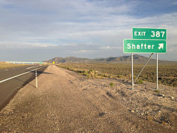
The Nevada Northern Railway was a railroad in the U.S. state of Nevada, built primarily to reach a major copper producing area in White Pine County, Nevada. The railway, constructed in 1905-06, extended northward about 140 miles (230 km) from Ely to connections with the Western Pacific Railroad at Shafter and Southern Pacific Railroad at Cobre. In 1967 NN reported 40 million net ton-miles of revenue freight on 162 miles of line.

Mina is a census-designated place in Mineral County in west-central Nevada, United States. It is located along U.S. Route 95 at an elevation of 4,560 feet (1,390 m). The 2010 population was 155.

Nelson is a census-designated place in Clark County, Nevada, United States. The community is in the Pacific Standard Time zone. The location of Nelson is in El Dorado Canyon, Eldorado Mountains. The town is in the southeast region of the Eldorado Valley. As of the 2010 census it had a population of 37.

Delamar, Nevada, nicknamed The Widowmaker, is a ghost town in central eastern Nevada, USA along the east side of the Delamar Valley. During its heyday, primarily between 1895 and 1900, it produced $13.5 million in gold.
Interstate 80 (I-80) traverses the northern portion of the U.S. state of Nevada. The freeway serves the Reno–Sparks metropolitan area and passes through the towns of Fernley, Lovelock, Winnemucca, Battle Mountain, Carlin, Elko, Wells and West Wendover on its way through the state.

Montello is a census-designated place (CDP) in Elko County, Nevada, United States. It is home to Montello Elementary School, which is part of the Elko County School District. The population of Montello was 50 as of the 2018 American Community Survey. Two small bars and a market/motel selling fuel and sundries comprise the business district. Various cattle ranching operations surround the area.

Gold Point, Nevada is a well preserved ghost town in Esmeralda County, Nevada. The community was named after the local gold-mining industry. Gold Point is the southern terminus of Nevada State Route 774.

Laws is an unincorporated community in Inyo County, California. Laws is located 4 miles (6.4 km) northeast of Bishop on U.S. Route 6, towards the Nevada state line. Laws has been noted for its unusual place name.

The Los Angeles and Salt Lake Railroad was a rail company that completed and operated a railway line between its namesake cities, via Las Vegas, Nevada. Incorporated in Utah in 1901 as the San Pedro, Los Angeles and Salt Lake Railroad, the line was largely the brainchild of William Andrews Clark, a Montana mining baron and United States Senator. Clark enlisted the help of Utah's U.S. Senator Thomas Kearns, mining magnate and newspaper man, to ensure the success of the line through Utah. Construction of the railroad's main line was completed in 1905. Company shareholders adopted the LA&SL name in 1916. The railway was also known by its official nickname, "The Salt Lake Route", and was sometimes informally referred to as "The Clark Road". The tracks are still in use by the modern Union Pacific Railroad, as the Caliente, Sharp, and Lynndyl Subdivisions.

You Bet is a small unincorporated community in Nevada County, California. You Bet is located in the Sierra Nevada foothills, 7 miles (11.3 km) east of Grass Valley and 5.5 miles (8.9 km) northeast of Chicago Park.

The Bodie & Benton Railway was a 3 ft narrow gauge common carrier railroad in California, from the Mono Mills to a terminus in Bodie, now a ghost town, in Mono County. It was unusual among U.S. railroads in that it was completely isolated from the rest of the railroad system.
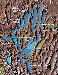
The Lahontan Valley is a basin in Churchill County, Nevada, United States. The valley is a landform of the central portion of the prehistoric Lake Lahontan's lakebed of 20,000-9,000 years ago. The valley and the adjacent Carson Sink represent a small portion of the lake bed. Humboldt Lake is to the valley's northeast. Pyramid Lake is west. Walker Lake is to the south.
The Goshute Valley is an endorheic landform of the Great Basin in Elko County, Nevada, United States.

Sodaville is an extinct town in Mineral County, in the U.S. state of Nevada. The GNIS classifies it as a populated place.
Excelsior is a ghost town in Elko County, in the U.S. state of Nevada.
Tulasco is an extinct town in Elko County, in the U.S. state of Nevada.