Related Research Articles

Tuscarora is an unincorporated community in Elko County, Nevada, United States. Tuscarora is part of the Elko Micropolitan Statistical Area.

Midas is a small unincorporated community in Elko County, Nevada. Although its population has fluctuated greatly over the years and it often appears on ghost town lists, it has never been completely abandoned.

Mountain City is a small census-designated place in Elko County, Nevada, United States, within the Mountain City Ranger District of the Humboldt-Toiyabe National Forest. The community is located on State Route 225, approximately 16 miles (26 km) south of the Idaho border, is situated on the Owyhee River at an elevation of approximately 5,620 feet (1,710 m).
Lee is an unincorporated community in Elko County, Nevada, United States. The community is located on the reservation land belonging to, and constituting the sole organized community of, the South Fork Band of the Te-Moak Tribe of Western Shoshone Indians of Nevada. Lee is located at the western foothills of the Ruby Mountains range, within the Elko Micropolitan Statistical Area.

North Fork is an unincorporated community in Elko County, Nevada, United States. The ZIP Code of North Fork, Nevada is 89801.
Cobre is a ghost town in Elko County, Nevada, United States.
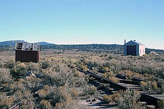
Rowland is a ghost town in northern Elko County, Nevada, United States.

Shafter is a ghost town in Elko County, Nevada, United States.
Sprucemont is a ghost town in Elko County, in the U.S. state of Nevada. The GNIS classifies it as a populated place.
Huntington is a ghost town in Elko County, Nevada, United States.
Excelsior is a ghost town in Elko County, in the U.S. state of Nevada.
Fairlawn is a ghost town in Elko County, in the U.S. state of Nevada.
Black Forest is an extinct town in Elko County, in the U.S. state of Nevada.
Fenelon is an extinct town in Elko County, in the U.S. state of Nevada. The GNIS classifies it as a populated place.
Flowery Lake is a swamp in the Elko County of the U.S. state of Nevada. Flowery Lake was named for the flowers lining its perimeter.

Gold Creek is an extinct town in Elko County, Nevada, United States.
Loray is an extinct town in Elko County in Nevada. The GNIS classifies it as a populated place.
Moleen is an extinct town in Elko County, Nevada. The Geographic Names Information System classifies it as a populated place.
Tobar is an extinct town in Elko County, in the U.S. state of Nevada.
White Rock is an extinct town in Elko County, in the U.S. state of Nevada.
References
- 1 2 U.S. Geological Survey Geographic Names Information System: Silver Zone
- ↑ Tingley, Joseph V. (1981). Summary Report, Mineral Inventory of the Wells Resource Area, Elko District, Elko County, Nevada. NV Bureau of Mines & Geology. p. 34. GGKEY:2T2G65C6HY8.
- ↑ U.S. Geological Survey Geographic Names Information System: Silver Zone Post Office
- ↑ Federal Writers' Project (1941). Origin of Place Names: Nevada (PDF). W.P.A. p. 28.
Municipalities and communities of Elko County, Nevada, United States | ||
|---|---|---|
| Cities |  | |
| CDPs | ||
| Other unincorporated communities | ||
| Indian reservations | ||
| Ghost towns |
| |
| Footnotes | ‡This populated place also has portions in an adjacent county or counties | |
Coordinates: 40°55′13″N114°21′12″W / 40.92028°N 114.35333°W
| | This Elko County, Nevada state location article is a stub. You can help Wikipedia by expanding it. |