In all modern states, a portion of land is held by central or local governments. This is called public land, state land, or Crown land. The system of tenure of public land, and the terminology used, varies between countries. The following examples illustrate some of the range.

The Iroquois National Wildlife Refuge is a wildlife refuge in Genesee and Orleans counties in western New York. The refuge is located between the cities of Buffalo and Rochester and is operated by the United States Fish and Wildlife Service.
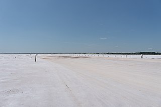
The Salt Plains National Wildlife Refuge is part of the United States system of national wildlife refuges. It is located in Alfalfa County in northern Oklahoma, north of Jet, along Great Salt Plains Lake, which is formed by a dam on the Salt Fork of the Arkansas River.

The Arthur R. Marshall Loxahatchee National Wildlife Refuge is a 145,188-acre (587.55 km2) wildlife sanctuary is located west of Boynton Beach, in Palm Beach County, Florida. It is also known as Water Conservation Area 1 (WCA-1). It includes the most northern remnant of the historic Everglades wetland ecosystem.

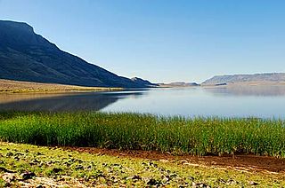
The Ruby Lake National Wildlife Refuge is located in southwestern Elko County and northwestern White Pine County in the northeastern section of the state of Nevada in the western United States. Established in 1938, as of 2023 it encompasses 39,928 acres (161.58 km2) of wetlands in Ruby Valley, just east of the Ruby Mountains and just south of Harrison Pass. It is 16 miles (26 km) long, up to 3 miles (4.8 km) in width, and lies at an elevation of 6,000 feet (1,800 m). Once the bed of a 200-foot (61 m) deep lake, it is now a network of spring-fed marshes and shallow ponds serving as a habitat for hundreds of species of native and migratory birds and mammals.

The Detroit River International Wildlife Refuge is the only international wildlife refuge in North America. Established in 2001 and managed jointly by the United States Fish and Wildlife Service and the Canadian Wildlife Service, it is located in a major metropolitan area. The Detroit River International Wildlife Refuge is one of over 540 National Wildlife Refuges managed by the U.S. Fish and Wildlife Service within the Department of the Interior. It occupies 7.88 square miles (20.41 km2) of scattered property but has drawn boundaries for further expansion.

The Lower Suwannee National Wildlife Refuge (LSNWR) is part of the United States National Wildlife Refuge System. It is located in southeastern Dixie and northwestern Levy counties on the western coast of Florida, approximately fifty miles southwest of the city of Gainesville.

The Okefenokee National Wildlife Refuge is a 402,000‑acre (1,627 km2) National Wildlife Refuge located in Charlton, Ware, and Clinch Counties of Georgia, and Baker County in Florida, United States. The refuge is administered from offices in Folkston, Georgia. The refuge was established in 1937 to protect a majority of the 438,000 acre (1,772 km2) Okefenokee Swamp. Though often translated as "land of trembling earth", the name "Okefenokee" is likely derived from Hitchiti oki fanôːki "bubbling water".

Malheur National Wildlife Refuge is a National Wildlife Refuge located roughly 30 miles (48 km) south of the city of Burns in Oregon's Harney Basin. Administered by the United States Fish and Wildlife Service, the refuge area is roughly T-shaped with the southernmost base at Frenchglen, the northeast section at Malheur Lake and the northwest section at Harney Lake.

The Banks Lake National Wildlife Refuge is a 4,049 acre (16.4 km2) National Wildlife Refuge located in Lanier County, Georgia. Banks Lake is a natural pocosin or sink of ancient geologic origin. The refuge was established in 1985 for the protection and conservation of this unique environment as well as migratory and resident wildlife.

The Lake George State Forest is a designated protected area and state forest in the U.S. state of Florida. The 21,176-acre (8,570 ha) forest is located in northwestern Volusia County, Florida, near Lake George and the communities of Pierson, Barberville, and Volusia. It is overseen by the Florida Forest Service within the Florida Department of Agriculture and Consumer Services.

Bandon Marsh National Wildlife Refuge is a U.S. National Wildlife Refuge on Oregon's coast. It is one of six National Wildlife Refuges comprising the Oregon Coast National Wildlife Refuge Complex and is renowned among bird watchers for being able to view rare shorebirds including ruff, Hudsonian godwit, and Mongolian plover. The refuge was last expanded in 1999, it now has 889 acres (3.60 km2) in two units: Bandon Marsh and Ni-les'tun.
Ruby Valley is an unincorporated community in Ruby Valley, in Elko County, Nevada, United States.
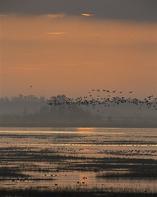
Lacassine National Wildlife Refuge is located in Cameron and Evangeline Parishes in southwestern Louisiana, was established in 1937 by Executive Order No. 7780 as "a refuge and breeding ground for migratory birds and other wildlife." The refuge is nearly 35,000 acres (140 km2) in size, including 653 acres (2.64 km2) leased from the Cameron Parish School Board. The Evangeline Parish unit is called Duralde Prairie and is currently being developed. It is located south of the city of Eunice.
The John H. Chafee National Wildlife Refuge is a national wildlife refuge of the United States, located along the Narrow River on the southern coast of Rhode Island.
Hart Lake is a shallow lake in the Warner Valley of eastern Lake County, Oregon, United States. The lake covers 7,324 acres (29.64 km2) and has the most stable water level within the valley's Warner Lakes chain. The lake is named for the heart-shaped brand used by the pioneer Wilson and Alexander cattle ranch established near the lake. Much of the land around Hart Lake is administered by the Bureau of Land Management (BLM) and the United States Fish and Wildlife Service (FWS). The lake and the surrounding wetlands support a wide variety of birds and other wildlife. Recreational opportunities on and near Hart Lake include hunting, fishing, bird watching, and boating.

Hagerman National Wildlife Refuge (HNWR), a haven for migratory birds and other wildlife, lies in northwestern Grayson County, Texas, on the Big Mineral Arm of Lake Texoma, on the Red River between Oklahoma and Texas. This National Wildlife Refuge is made up of water, marsh, and upland habitat. Visitors can hike, observe wildlife, hunt, and fish throughout the year.
Slade National Wildlife Refuge is a 3,000-acre (12 km2) National Wildlife Refuge in Kidder County, North Dakota. It was established in 1941 when the property was donated by G.T. Slade, a Northern Pacific Railroad executive. It is managed under the Long Lake National Wildlife Refuge. It contains Harker Lake and Upper Harker Lake.

The Summer Lake Wildlife Area is a 29.6-square-mile (77 km2) wildlife refuge located on the northwestern edge of the Great Basin drainage in south-central Oregon. It is administered by the Oregon Department of Fish and Wildlife. The refuge is an important stop for waterfowl traveling along the Pacific Flyway during their spring and fall migrations. The Summer Lake Wildlife Area also provides habitat for shorebirds and other bird species as well as wide variety of mammals and several fish species. The Ana River supplies the water for the refuge wetlands.

