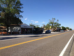
Montello, Nevada | |
---|---|
Coordinates: 41°16′01″N114°11′49″W / 41.26694°N 114.19694°W [1] | |
Country | United States |
State | Nevada |
County (United States) | Elko |
Area | |
• Total | 0.41 sq mi (1.07 km2) |
• Land | 0.41 sq mi (1.07 km2) |
• Water | 0.00 sq mi (0.00 km2) |
Elevation | 4,892 ft (1,491 m) |
Population (2020) | |
• Total | 66 |
• Density | 160.58/sq mi (61.96/km2) |
Time zone | UTC-8 (Pacific (PST)) |
• Summer (DST) | UTC-7 (PDT) |
ZIP code | 89830 |
FIPS code | 32-48400 |
GNIS feature ID | 2583943 [1] |
Montello is a small desert village in Elko County, Nevada, United States. It is home to Montello Elementary School, which is part of the Elko County School District. The population of Montello was 50 as of the 2018 American Community Survey. [3] Various cattle ranching operations surround the area.
Montello is part of the Elko Micropolitan Statistical Area and also a part of a census-designated place (CDP) named after it.
The first permanent settlement at Montello was made in 1869. [4] The town of Montello was established in 1904 as a "division point" (operations base) for the Southern Pacific Railroad. Montello's development was prompted by the construction of the Lucin Cutoff across the Great Salt Lake in Utah, a line that bypassed the area's former division point town of Terrace, Utah. Many of the original houses in Montello were moved there from Terrace and nearby Kelton, Utah. Montello was originally named "Bauvard", and received its current name in 1912. The word Montello is Italian for "little mountain" and was probably given by one of the early Italian settlers.
Montello was at its peak in the 1910s and early 1920s, with a population of perhaps 800. While the town's economic life was dominated by the railroad, it also served as a community center for local ranchers and as a supply point for the nearby mining camp of Delano. Montello began declining in the late 1920s, however; railroad employment began to lessen and a 1925 fire devastated the town's business district. The primary factor in Montello's decline, though, was the railroad's shift from steam to diesel locomotives, which took place in the 1940s and early 1950s. This rendered the servicing facilities at Montello obsolete, and they were removed by the Southern Pacific in the 1950s.
In February 2017, the town was flooded after a very wet winter. The failure of the "Twenty One Mile" earthen dam did not contribute to Montello flooding. [5] Sections of State Route 30, State Route 233, and U.S. Highway 93 were closed, some sections of road were washed out and rail traffic had to be re-routed. [6]
Montello is located in eastern Elko County along Nevada State Route 233, 23 miles (37 km) northeast of Interstate 80 at Oasis and 11 miles (18 km) southwest of the Utah border. Elko, the county seat, is 100 miles (160 km) to the west.
According to the U.S. Census Bureau, the Montello CDP has an area of 0.39 square miles (1.0 km2), all of it land. No information is provided for the village alone. [3]
Because the United States Census Bureau has included Montello in one of its census-designated places (CDP), published census information only applies to the entire CDP, not the village alone.
Census | Pop. | Note | %± |
---|---|---|---|
2020 | 66 | — | |
U.S. Decennial Census [7] |
Elko County is a county in the northeastern corner of Nevada, United States. As of the 2020 census, the population was 53,702. Its county seat is Elko. The county was established on March 5, 1869, from Lander County.
Grandwood Park is a census-designated place (CDP) in Warren Township, Lake County, Illinois, United States. Per the 2020 census, the population was 5,297.
Elko is a city in the U.S. state of Nevada and the county seat of Elko County. As of the official 2020 U.S. Census, the city has a population of 20,564. Elko serves as the center of the Ruby Valley, a region with a population of over 55,000. Elko is 21 miles (34 km) from Lamoille Canyon and the Ruby Mountains, providing year-round access to recreation, including hiking, skiing, hunting, and more than 20 alpine lakes. The city straddles the Humboldt River. Spring Creek, Nevada, serves as a bedroom community 6 miles (10 km) from the city with a population of 13,805.
Owyhee is a census-designated place (CDP) in Elko County, Nevada, United States, along the banks of the Owyhee River. The population was 953 at the 2010 census. It is part of the Elko Micropolitan Statistical Area. It is the primary town of the federally recognized Shoshone-Paiute tribe's Duck Valley Indian Reservation, which covers portions of northern Nevada and southern Idaho, and the majority of its population are Native American.
Spring Creek is a census-designated place (CDP) in central Elko County, in northeastern Nevada in the western United States. It mainly serves as a bedroom community for the businesses and industries in and around the nearby city of Elko. It is part of the Elko Micropolitan Statistical Area. The population was 12,361 at the 2010 census.
Wells is a small city in Elko County, in northeast Nevada in the western United States. The population was 1,292 at the 2010 census. Wells is located at the junction of Interstate 80 and U.S. Route 93, approximately 50 miles (80 km) east of Elko and is part of the Elko micropolitan area.
Dayton is an unincorporated community and census-designated place (CDP) in Lyon County, Nevada, United States. The population was 15,153 at the 2020 census. Dayton is the second oldest Nevada settlement. It is home to the oldest hotel in Nevada.
Hawthorne is an unincorporated community and census-designated place (CDP) in Mineral County, Nevada, United States. As of the 2020 census, the population was 3,118. It is the county seat of Mineral County. The nearby Hawthorne Army Depot is the primary economic base of the town.
Jackpot is an unincorporated community and census-designated place (CDP) in Elko County, Nevada, United States. The population was 855 as of the 2020 census. Located less than one mile (1.6 km) from the Idaho border on US 93, Jackpot has been a popular casino gaming destination for residents of Idaho and other neighboring states since its founding.
Panaca is an unincorporated town in eastern Lincoln County, Nevada, United States, on State Route 319, about 1 mile east of U.S. Route 93, near the border with Utah. Its elevation is 4,729 feet above sea level. As of the 2010 census, it had a population of 963. It is one of only two cities in Nevada that prohibits gambling, the other being Boulder City.
Mina is an unincorporated community and census-designated place (CDP) in Mineral County in west-central Nevada, United States. It is located along U.S. Route 95 at an elevation of 4,560 feet (1,390 m). The population at the 2020 census was 127.
Littlefield is an unincorporated community and census-designated place in Mohave County, Arizona, United States, that is located in the Arizona Strip region. As of the 2020 census, its population was 256, a decline from the figure of 308 tabulated in 2010. It lies just south of Interstate 15, next to the Virgin River, approximately 10 miles (16 km) northeast of Mesquite, Nevada. Littlefield is located in the 86432 ZIP Code.
Nelson is a census-designated place in Clark County, Nevada, United States. The community is in the Pacific Standard Time zone. The location of Nelson is in El Dorado Canyon, Eldorado Mountains. The town is in the southeast region of the Eldorado Valley. As of the 2010 census it had a population of 37.
Crescent Valley is a census-designated place (CDP) in Eureka County, Nevada, United States, directly off Nevada State Route 306. It is the site of Crescent Valley Elementary School, Crescent Valley Fair Grounds, and Crescent Valley Community Park. The census-designated place (CDP) of Crescent Valley had a population of 483 as of the 2020 census.
Arcola is a census-designated place in Loudoun County, Virginia, United States. The population as of the 2010 United States Census was 233.
Oasis is a census-designated place (CDP) located in eastern Elko County, Nevada, United States, at the junction of State Route 233 and Interstate 80, 31 miles (50 km) northwest of the Utah border and 77 miles (124 km) east of Elko. As of the 2008 American Community Survey it had a population of 34. As of 2020, Oasis had a population of just four.
Beaver Dam is an unincorporated community and census-designated place (CDP) in Mohave County, Arizona, United States, that is located in the Arizona Strip region and was settled on December 2, 1863. It is located along Interstate 15 approximately 10 miles (16 km) northeast of Mesquite, Nevada. It is located in the 86432 ZIP Code. It had a population of 1,552 as of the 2020 census, a decline from the figure of 1,962 tabulated in 2010.
Terrace is a ghost town in the Great Salt Lake Desert in west-central Box Elder County, Utah, United States.
Laurys Station is an unincorporated community and census-designated place (CDP) in North Whitehall Township in Lehigh County, Pennsylvania. It is part of the Lehigh Valley, which had a population of 861,899 and was the 68th-most populous metropolitan area in the U.S. as of the 2020 census. It is located approximately 9 miles (14 km) north of Allentown and about 6 miles (10 km) southeast of Walnutport.
Oasis is a census-designated place in northeastern Millard County, Utah, United States. The population was 75 at the 2010 census. Once the main rail shipping point in Millard County, Oasis declined in importance after the establishment of Delta, now the county's largest city.
Media related to Montello, Nevada at Wikimedia Commons