
Tuscarora is an unincorporated community in Elko County, Nevada, United States. The community lies on the east side of the Tuscarora Mountains approximately 40 miles north of Carlin. Tuscarora is part of the Elko Micropolitan Statistical Area. Far from being a ghost town, as several websites proclaim, Tuscarora is home to two schools, a library, a post office and a bar and grill, as well as homes for its remaining residents.
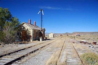
Currie is an unincorporated community in Elko County, Nevada, United States. It is often considered a ghost town, and its population is around 20.

Midas is a small unincorporated community in Elko County, Nevada. Although its population has fluctuated greatly over the years and it often appears on internet ghost town lists, it has never been completely abandoned, and one can meet many of the living citizenry at the aptly named Ghost Town Saloon, its sole business. Alongside Jarbidge, the town was known as one of the biggest twentieth-century gold mining towns in Elko County.
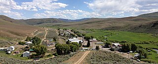
Mountain City is a small census-designated place in Elko County, Nevada, United States, within the Mountain City Ranger District of the Humboldt-Toiyabe National Forest. The community, located on State Route 225 approximately 16 miles (26 km) south of the Idaho border, is situated on the Owyhee River at an elevation of approximately 5,620 feet (1,710 m).

North Fork is an unincorporated community in Elko County, Nevada, United States. The ZIP Code of North Fork, Nevada is 89801.
Contact is an unincorporated community in Elko County, Nevada, United States. It is located on a mineral-rich granite intrusion and there are many mines nearby.

San Jacinto is a ghost town in along Salmon Falls Creek in northern Elko County, Nevada, United States. It is part of the Elko Micropolitan Statistical Area.
The Goshute Valley is an endorheic landform of the Great Basin in Elko County, Nevada, United States.

Pequop or Pequop Siding is a ghost town in Elko County, Nevada, United States. It was located west of Toano on the route around the north end of the Pequop Mountains between Cobre and Wells. It was first a stop station of the Central Pacific Railroad and later a non-agency station on the Southern Pacific Railroad. Several buildings were erected to house section crews.
Rio Tinto is a ghost town in Elko County, Nevada in the United States.
Rowland is a ghost town in northern Elko County, Nevada, United States.

Shafter is a ghost town in Elko County, Nevada, United States.
Afton is a ghost town Elko County, Nevada, in the United States.

Charleston is a ghost town in Elko County, Nevada, United States. It lies along the Bruneau River just south of the Mountain City and Jarbidge Ranger Districts of the Humboldt-Toiyabe National Forest and is near the southwest edge of the Jarbidge Wilderness.
Sprucemont is a ghost town in Elko County, in the U.S. state of Nevada. The GNIS classifies it as a populated place.
Huntington is a ghost town in Elko County, Nevada, United States.
Dutton is a ghost town in Elko County, in the U.S. state of Nevada.
Excelsior is a ghost town in Elko County, in the U.S. state of Nevada.
Fairlawn is a ghost town in Elko County, in the U.S. state of Nevada.

Gold Creek is an extinct town in Elko County, Nevada, United States.


