
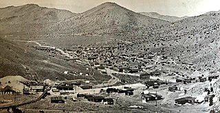
Hunter is a ghost town along the Humboldt River in Elko County, Nevada, United States. [1]
Hunter is a ghost town along the Humboldt River in Elko County, Nevada, United States. [1]
In 1871 lead and silver were found in Hunter. In 1877 a post office was established there. In those days, Hunter had six saloons, a blacksmith shop, restaurants, two stores and 40 to 50 homes. Mines were idle in 1884 but resurged by 1905. In 1872, mines at Hunter produced $208,000 in material. However, the Hunter District had to pay a high tax. Ore was discovered in the area, leading to mines that attracted more attention. This caused the population to reach a peak population of 80 inhabitants in 1877. By these times, Hunter had 40 houses, restaurants, several saloons and a post office. The early years of the 20th century were the start of the end of Hunter. Now, only smelter ruins mark the site of the old town. [2]

Virginia City is a census-designated place (CDP) that is the county seat of Storey County, Nevada, and the largest community in the county. The city is a part of the Reno–Sparks Metropolitan Statistical Area.

Panamint City is a ghost town in the Panamint Range, near Death Valley, in Inyo County, California, US. It is also known by the official Board of Geographic Names as Panamint. Panamint was a boom town founded after silver and copper were found there in 1872. By 1874, the town had a population of about 2,000. Its main street was one mile (1.6 km) long. Panamint had its own newspaper, the Panamint News. Silver was the principal product mined in the area. The town is located about three miles northwest of Sentinel Peak. According to the National Geographic Names Database, NAD27 latitude and longitude for the locale are 36°07′06″N117°05′43″W, and the feature ID number is 1661185. The elevation of this location is identified as being 6,280 feet AMSL. The similar-sounding Panamint Springs, California, is located about 25.8 miles at 306.4 degrees off true north near Panamint Junction.

Belmont is a ghost town in Nye County, Nevada, United States along former State Route 82. The town is a historic district listed in the National Register of Historic Places. It is Nevada Historical Marker number 138.
Round Mountain is an unincorporated town in Nye County, Nevada, United States. The population of Round Mountain as of 2014 is 1,868. The town's ZIP code is 89045.

Cherry Creek is a historic mining town located in northern White Pine County, in northeastern Nevada in the western United States. It is a census county division (CCD), with a population at the 2010 census of 72.
Belleville, Nevada, in Mineral County, Nevada, United States, was a mining town that rose up around the milling of ore shipped in from nearby mines. Today it is a ghost town.
Vanderbilt was a short-lived gold mining town located in San Bernardino County, California, United States. It existed between 1893 and 1895. At its peak it may have had a population of about 400 people.

Wonder, Nevada, is a ghost town in Churchill County, Nevada, approximately 39 miles (63 km) east of Fallon.

Rawhide, Nevada was a town in Mineral County, Nevada, approximately 55 miles southeast of Fallon. The site of Rawhide has been dismantled by recent mining activity, with little or nothing remaining to be seen.
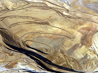
Rochester was a silver-mining town in Pershing County, Nevada, USA, approximately 110 mi (180 km) east of Reno. It is now a ghost town. Lower Rochester is still accessible to visitors, but was largely destroyed by a wildfire in 2012; Upper Rochester has been buried under mine tailings of the more recent Coeur Rochester open pit mine.
Lee is a former settlement in Inyo County, California.
Moore's Flat was a historic mining town located on the San Juan Ridge about 19 miles northeast of Nevada City, California and about 5 miles northeast of North Bloomfield, California. The town was about 1 mile south of the Middle Yuba at an elevation of about 4200 ft. On either side of it, lay the mining towns of Orleans Flat and Woolsey's Flat, each about I mile apart. All three were settled around 1851 and their histories frequently intertwine. Collectively, they are sometimes referred to as "The Flats." All three were part of Eureka Township.
Carbondale, in Orange County, California, is a historical coal mining town in Santiago Canyon, where Santiago Creek had its confluence with Silverado Creek in Silverado, California. It had a post office from May 11, 1881, to January 29, 1884, when it was closed and mail sent to the Santa Ana post office.
Rockland is a ghost town in Lyon County, Nevada, in the United States. The town that grew up around the mine was named Rockland, probably for the rocky cliffs that surrounded the area.
Rochford is an unincorporated community in Pennington County, South Dakota, United States. It is not tracked by the U.S. Census Bureau.

Springdale is a privately owned ghost town in Nevada, United States. It is inaccessible to the general public.

Seven Troughs is a ghost town in Pershing County, Nevada, United States.
Johnnie is a populated place in Nye County, in the U.S. state of Nevada about 15 miles north of Pahrump.

Bullionville is a ghost town in Lincoln County, Nevada, United States, 1/4 mile east of U.S. Route 93, one mile north of Panaca and 10 miles (16 km) south of Pioche. The town prospered between 1870 and 1882, and is now abandoned.

Tenabo is a ghost town in Lander County, Nevada United States.
![]() Media related to Hunter, Nevada at Wikimedia Commons
Media related to Hunter, Nevada at Wikimedia Commons
Municipalities and communities of Elko County, Nevada, United States | ||
|---|---|---|
| Cities |  | |
| CDPs | ||
| Other unincorporated communities | ||
| Indian reservations | ||
| Ghost towns |
| |
| Footnotes | ‡This populated place also has portions in an adjacent county or counties | |