
The Black Rock Desert is a semi-arid region (in the Great Basin shrub steppe eco-region), of lava beds and playa, or alkali flats, situated in the Black Rock Desert–High Rock Canyon Emigrant Trails National Conservation Area, a silt playa 100 miles (160 km) north of Reno, Nevada that encompasses more than 300,000 acres (120,000 ha) of land and contains more than 120 miles (200 km) of historic trails. It is in the northern Nevada section of the Great Basin with a lakebed that is a dry remnant of Pleistocene Lake Lahontan.

Stone House is a ghost town in Humboldt County, Nevada, United States.
Ursine is an unincorporated community and census-designated place in Lincoln County, Nevada, United States. It is located in the foothills of the White Rock Mountains on Eagle Valley about two miles downstream from the Eagle Valley Reservoir and Spring Valley State Park. The population was 91 at the 2010 census.
Cobre is a ghost town in Elko County, Nevada, United States.
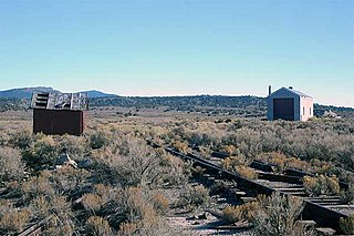
Sulphur, Nevada, is a ghost town in Humboldt County, Nevada that was a Feather River Route station in the Black Rock Desert along the Kamma Mountains.
Nyala is an extinct town in Nye County, in the U.S. state of Nevada.

Sunnyside is a small unincorporated community in the White River Valley of eastern Nevada, near the southern terminus of the Egan Range. The site is located on State Route 318 approximately 31 miles by road south of Lund in White Pine County, the closest town, and 63 miles by road north of Hiko in Lincoln County.

Schellbourne, formerly known as Fort Schellbourne and Schell Creek Station is an unincorporated community located in White Pine County in Nevada, United States, located 43 miles (69 km) north of Ely. The town was a stopover along the Central Overland Route, Pony Express and original routing of the Lincoln Highway. It is today Nevada Historical Marker number 51. The site was listed on the National Register of Historic Places in 1972. Its boundaries were increased in 1977.
Sprucemont is an ghost town in Elko County, in the U.S. state of Nevada. The GNIS classifies it as a populated place.
Allred is a ghost town situated in Nye County, Nevada. A post office in the settlement opened on April 17, 1911 with Allen Oxborrow and George Kump as postmasters. The post office was closed more than a year later on October 31, 1912. There are no visible remains left of Allred.
White Plains is an ghost town in Churchill County, in the U.S. state of Nevada.

Gold Creek is an extinct town in Elko County, Nevada, United States.
Tobar is an extinct town in Elko County, in the U.S. state of Nevada.
Gilbert is an extinct town in Esmeralda County, in the U.S. state of Nevada.
Birch is an extinct town in Eureka County, in the U.S. state of Nevada. Birch is located to the west of the Diamond Mountains, 26 miles northeast of Eureka.
Acoma is an extinct town in Lincoln County, in the U.S. state of Nevada.
Rox is an extinct town in Lincoln County, in the U.S. state of Nevada.
Johnnie is a populated place in Nye County, in the U.S. state of Nevada about 15 miles north of Pahrump.
Pleasant Valley, is a ghost town, a historical mining town, and a former populated place in White Pine County, Nevada. There was a post office from March 1892 until April 1894.
Regan is a ghost town, a historical mining town, and a former populated place in White Pine County, Nevada. It had its own Regan post office from August 1906 to November 1907. Its site lies at an elevation of 6,863 feet / 2,092 meters, in Tippett Canyon in the South Mountains.


